

To view the latest Oklahoma drought map, CLICK HERE.
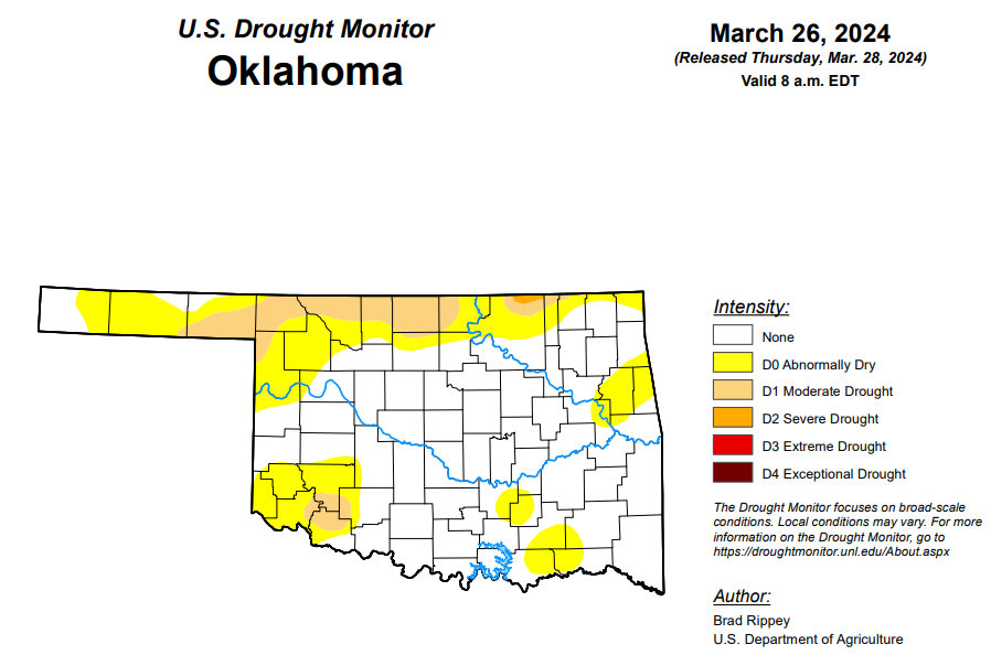
According to the latest Oklahoma drought monitor report, exceptional drought remains at zero percent, unchanged from the start of the calendar year.
Extreme drought or worse remains at zero percent, unchanged from the start of the calendar year.
Severe drought or worse is unchanged from the past six weeks at .19 percent.
Moderate drought or worse is now at 8.83 percent, up from last week’s 3.53 percent.
Abnormally dry or worse conditions are now at 33.76, improved from last week’s 43.56 percent.
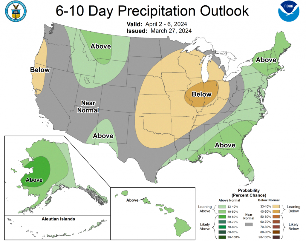
According to the 6-to-10-day precipitation outlook map, the western half of the panhandle can expect “near normal” changes of precipitation through April 6th. The rest of the state is leaning below a 33 to 40 percent chance of precipitation through April 6th.
At the Emergency Drought Commission meeting on March 26th, State Climatologist Gary McManus gave a drought update for Oklahoma. According to McManus, drought conditions are lower now due to El Nino and the strengthening of the subtropical Jetstream.
“We are really lucky we had that El Nino because that is one of the reasons we are so good right now,” McManus said.
McManus said drought conditions began for Oklahoma in August of 2021, and since that time, the state has seen three flash droughts. Most of the state saw a surplus of moisture this winter, McManus said, and although southeast Oklahoma missed some of the bigger rains, it has since made up for it.
Drought concerns for the spring and summer of 2024 are elevated, McManus said, because La Nina is forecasted to make a comeback.
“Flash drought is imminent across north and west Oklahoma,” McManus said.
Looking back, McManus said summers after the last three big El Nino events, like the one we are seeing now, have typically been hot and dry, with below-normal precipitation and above-normal temperatures. This is concerning for farmers as the winter wheat crop comes out of dormancy and starts to progress because it will need moisture.
McManus said drought concerns for the fall of 2024 and spring of 2025 are also high. As of now, McManus said El Nino is expected to transition to neutral conditions by April-June, and there is a 62 percent chance of seeing La Nina by June-August.
With these predictions in mind, McManus advises producers to be mindful of what is to come and take proper precautions for future drought events.
To view the United States Drought Map, click here.
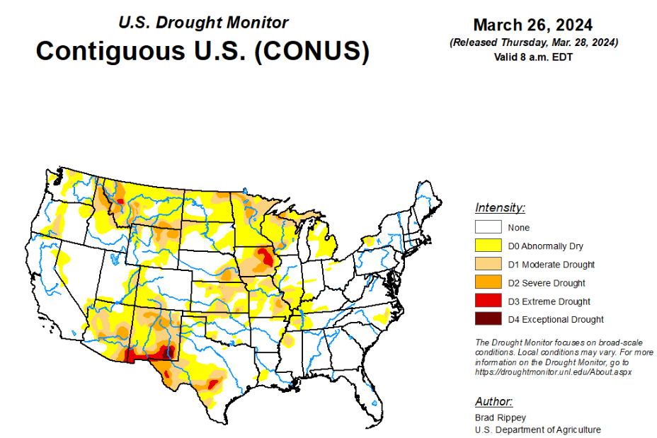
According to the latest U.S. Drought Monitor, a winter-like storm system crossing the central Plains and upper Midwest resulted in a variety of weather hazards, including blizzard conditions, high winds, heavy rain, and locally severe thunderstorms. That storm was preceded by a weaker system, which produced a stripe of snow from northern Montana into portions of the Great Lakes States. Combined, the two storms produced 40 to 50% of the season-to-date snowfall in 4 to 5 days at several upper Midwestern locations, including Eau Claire, Wisconsin, and Minneapolis-St. Paul, Minnesota. Though the winter-like storm eventually weakened and drifted northward into Canada, impacts lingered. For example, the wettest day ever observed during March was noted on the 23rd in mid-Atlantic locations such as Philadelphia, Pennsylvania, and New York’s LaGuardia and JFK Airports. Elsewhere, the West received widespread but generally light precipitation.
In the Southern Plains, additional heavy showers further trimmed coverage of abnormal dryness (D0) and moderate to severe drought (D1 to D2) in the mid-South and western Gulf Coast region. In fact, severe drought (D2) was eliminated from Mississippi, while moderate drought (D1) was eradicated from Louisiana. Farther west, however, there was modest expansion of dryness and drought in northern and western sections of Oklahoma and Texas. On March 24, high winds raised dust in western Texas, where Lubbock clocked a southwesterly wind gust to 73 mph and reported visibilities as low as 2 miles. On March 24, according to the U.S. Department of Agriculture, topsoil moisture was rated 44% very short to short in Texas, along with 27% in Oklahoma. On the same date, 51% of the winter wheat in Texas was rated in good to excellent condition, along with 70% of the crop in Oklahoma.
In the High Plains, while much of the region experienced precipitation, including late-season snow, there were some targeted areas of expansion of abnormal dryness (D0) and moderate drought (D1), especially in southern Kansas. General reductions in the coverage of D0 and moderate to severe drought (D1 to D2) were observed in several areas, including parts of the Dakotas, northern Kansas, and eastern sections of Montana and Nebraska. According to the U.S. Department of Agriculture, topsoil was rated more than 40% very short to short on March 24 in Wyoming (55%), North Dakota (49%), South Dakota (47%), Nebraska (47%), Kansas (45%).
In the West, drought changes were mostly minor, although a reassessment of season-to-date precipitation and conditions led to some drought improvement being depicted in parts of New Mexico. Approaching the traditional Western peak snowpack date of April 1, snow-water equivalencies were mostly near or above average, except in much of Montana, Washington, northern Idaho, and northeastern Wyoming. Those low snowpack numbers were reflected in ongoing moderate to extreme drought (D1 to D3) in the northern Rockies and environs.
Looking ahead, rain will linger along the Atlantic Coast through Thursday, with parts of interior New England experiencing a rain-to-snow transition on Friday. Farther west, Pacific storminess will initially affect the northern half of the western U.S. By Friday, however, the focus for stormy weather will shift into California. During the weekend, precipitation will spread farther inland across the Great Basin, Intermountain West, and parts of the Southwest. Early next week, precipitation will return across the nation’s mid-section, initially extending eastward from Colorado and Wyoming.
The NWS 6- to 10-day outlook for April 2 – 6 calls for the likelihood of near- or below-normal temperatures nationwide, except for warmer-than-normal weather in California, the Great Basin, northern New England, and southern Florida. Meanwhile, near- or above-normal precipitation across much of the country should contrast with drier-than-normal conditions in coastal sections of Oregon and northern California, as well as a broad area covering much of the eastern Plains, mid-South, and Midwest.
To view the 6-10 Day Precipitation Outlook Map, click here.
To view the 6-10 Day Temperature Outlook Map, click here.
To view the Monthly Drought Outlook Map, click here.


