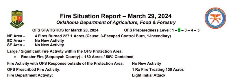
Statewide Discussion: Southwest winds will increase today following a drying day yesterday. Several controlled burns/prescribed fires occurred yesterday that will merit thorough mop-up and patrol limiting escape potential as winds increase through the day. A Red Flag warning is in effect today in Cimarron County as dry air flexes into the Panhandle. Today will have the highest concern through the Easter Weekend with dry air moving across the Panhandle counties each afternoon generally stalling along the OK/TX state line at the 100th Meridian. Dry conditions will persist through the weekend with diurnal burning periods. Increasing initial attack activity is expected with emergence of some large wildfires (>300 acres) although significant wildfire occurrence appears to be limited.
Today: Red Flag Warning in effect today in Cimarron County from Noon through 9:00 PM. Elevated fire weather will overspread much of the state today. In the Panhandle counties elevated criteria is driven largely by low afternoon relative humidity while elsewhere in Oklahoma the concern is supported by more intense, gusty winds. The fuelscape in the wheat belt in the vicinity of US 81 as well as areas along and south of I-44 continue to see improvements in herbaceous greenness offering several barriers to fire spread. The rangelands in north-central and northeastern Oklahoma
will also support active fire behavior, and while composite fuel moisture is not presenting undue resistance to control, suppression difficulty will be noticeable given stronger winds today.
Oklahoma Panhandle / Far Northwestern Oklahoma: Moderate overnight moisture recovery will quickly erode today yielding afternoon relative humidity values 10-17% as temperatures warm into the 77°-81° under partly cloudy skies. Fine-dead fuel moisture values will register 3% across the area supporting enhanced fuel receptiveness. West-southwest winds this afternoon sustained 13-19 mph with some higher gusts will support head fire rates if spread in rangeland fuels this afternoon at 127-190 ft/min and flame lengths 11-14 ft. Winds will relax a bit with sunset although overnight moisture recovery will be very slow to respond supporting an extended burning period today.
North-Central/Northeastern Oklahoma: The fire environment yesterday supported very good opportunity for conducting prescribed fires with several controlled burns as well. Those recently burned areas will require mop-up and patrol today as winds ratchet up challenging control lines, especially where heavier fuel concentrations are in proximity. Temperature will warm into the mid- to maybe upper-70°’s under some skycover with relative humidity values only getting to around 40%. Fine-dead fuel moisture will hover around 6-7% this afternoon. Southerly winds will increase through the day sustained 18-24 mph gusting to near 40 mph during peak heating this afternoon. Rangeland fuels in the area will support moderate to rapid rates of fire spread today dependent upon overall fuel loading. Head fire rates of spread on free burning fires at 130-190 ft/min with flame lengths 14-19 ft. should be anticipated during peak burning conditions today. Winds will persist into the evening although overnight moisture recovery is expected to be good.
Saturday: Dry conditions continue across Oklahoma with temperatures above-normal continuing. The highest fire danger indices will again develop in the Panhandle counties as dry air flexes back into the area while moderate fire danger indices are expected elsewhere in the state. Winds do relax on Saturday limiting fire spread potential although receptive fuels continue to dominate much of the landscape across northern Oklahoma. It is anticipated that several burns will occur ahead of precipitation potential early next week, especially in the Southern Flint Hills in north-central/northeastern Oklahoma.
Easter Sunday: Very good overnight moisture recovery will serve to stall development of concerning fire behavior although very dry air will again transition into the Panhandle counties coupled with strong southwesterly winds placing the highest fire danger indices in this area likely meriting a Red Flag Warning. Dry conditions persist across Oklahoma through the day although current forecast data holds skycover in place limiting insolation on wildland fuels reducing overall ignition potential. Additionally, rain chances move into the area overnight Sunday in southern Oklahoma extending into northeastern Oklahoma.
Near-Term: Rain chances, and some severe weather potential, enters the forecast for Monday throttling back fire danger concern. Realized precipitation will play a large role in determining fire danger moving into later in the week following a cold front.
County Burn Bans: Click HERE for the most current burn ban information