

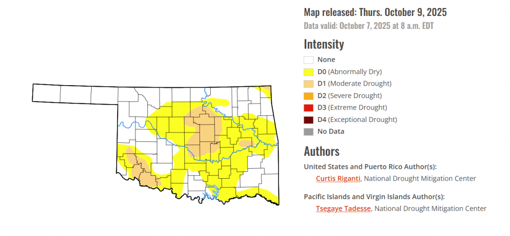
To view the latest Oklahoma drought map, CLICK HERE.
According to the latest Oklahoma Drought Monitor report, exceptional drought remains at 0 percent, unchanged from the start of the calendar year.
No Severe Drought: As of October 7, 2025, no part of Oklahoma is classified in the D2 (Severe), D3 (Extreme), or D4 (Exceptional) categories.
Rapid Expansion of Moderate Drought: The area under Moderate Drought (D1) has significantly expanded, covering 12.10% of the state, up from less than 5% the previous week.
Widespread Dryness: Over half of the state (52.13%) is now experiencing at least Abnormally Dry (D0) conditions, which is the pre-drought phase where crops begin to show stress and winter wheat germination may be delayed.
Historical Context: The current drought situation is vastly improved compared to one year ago (October 8, 2024), when 84.44% of the state was in some form of drought, and 23.41% was facing Extreme (D3) or worse conditions.
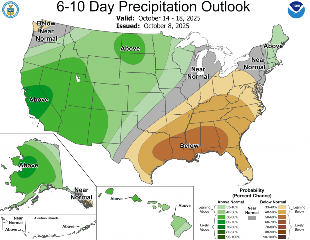
According to the 6-to-10-day precipitation outlook map, the panhandle and a small portion of northwestern Oklahoma are leaning above 33-40% chance of rain, central Oklahoma has a normal chance of rain, and southeastern Oklahoma is expecting below normal chances.
To view the United States Drought Map, CLICK HERE.
The recent pattern of numerous changes in the USDM continued with this week’s map release. Continued dry weather in the Northeast led to widespread worsening of drought and abnormal dryness there. From Missouri northward to the Great Lakes states, many locations saw drought or abnormal dryness worsen. In particular, intense short-term drought continued to worsen in parts of Missouri, Illinois, Indiana and Ohio. However, in southeast Missouri and in the Ohio River Valley and some parts of the Mississippi River Valley, welcome rains fell, locally over 3 inches, leading to widespread improvements in the ongoing drought and abnormal dryness in these areas. Much of Alabama, the Carolinas and Georgia saw drier weather, with local exceptions. As such, drought and abnormal dryness also expanded across portions of these states and a few spots in nearby Florida. Very heavy rain fell in southeast Louisiana; one area received over 5 inches of rain, resulting in a 2-category improvement in the USDM, surrounded by nearby 1-category improvements following the heavy rain. In West Louisiana, Oklahoma, and Texas, dry weather this week led to many degradations, primarily due to short-term dryness intensification. A few areas of central and southwest Texas are also seeing long-term dryness and drought, and saw some intensification this week. Drier weather this week in northeast Montana led to the development of a moderate drought there.
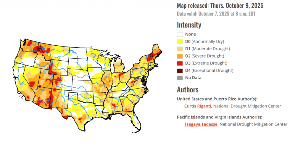
In the southern plains, Pockets of heavy rain, locally 3 inches or more, fell in western Tennessee and adjacent northwest Mississippi and northeast Arkansas, in southwest Mississippi, and in southeast Louisiana this week. The heavy rain was enough to improve overall conditions in much of western Tennessee, northeast Arkansas, and southeast Louisiana, where a localized 2-category improvement occurred. Parts of east-central and northeast Mississippi experienced significantly drier conditions this week, resulting in an expansion of moderate, severe, and extreme drought. In these areas, precipitation deficits grew, and soil moisture and streamflow continued to drop. Short-term dryness continued to intensify in south-central and west-central Louisiana, as well as across much of Texas and parts of Oklahoma, all of which experienced a mostly dry and warmer-than-normal week. Very dry weather over the last month continued in parts of Oklahoma, particularly in the areas north of Oklahoma City and southwest Oklahoma, where adverse impacts to agriculture were reported. In central and southwest Texas, recent dry weather has compounded the impacts of long-term dryness and drought.
In the High Plains, Temperatures this week across the region were mostly 5-15 degrees above normal, with parts of central Colorado and southern and western Wyoming experiencing closer to normal temperatures. Moderate to locally heavy precipitation fell in parts of the San Juan Mountains in southwest Colorado, the Rocky Mountains of northern Colorado, and across much of Wyoming, northwest South Dakota, and central to north-central North Dakota. Precipitation this week added to a generally wetter recent pattern in the San Juans, north-central Colorado and southeast Wyoming. In these areas, short- and medium-term precipitation deficits lessened and soil moisture conditions improved, allowing for some improvements to the ongoing drought and abnormal dryness. In north-central Kansas, moderate drought improved in some areas where locally over 2 inches of rain fell. In eastern Kansas, short-term abnormal dryness and moderate drought worsened in spots where streamflow and soil moisture levels dropped, along with growing precipitation shortages. In northeast Nebraska and southeast South Dakota, dry weather over the past couple of months continued this week, resulting in a significant expansion of abnormal dryness that also extended into northwest Iowa and southwest Minnesota.
In the Midwest, A few swaths of significant rain fell from southwest to central Iowa, across central Lower Michigan, and in the Ohio River Valley and Missouri Bootheel. In far southern parts of Ohio, Indiana and Illinois, western Kentucky and the Missouri Bootheel, this week’s rainfall improved conditions, as soil moisture and streamflow continued to recover and precipitation deficits lessened. As more data regarding the impact of recent rainfall becomes available, further changes to the map may occur in this region in the coming weeks. Short-term drought, with localized longer-term impacts, continued to intensify this week from southwest Missouri northeast into central and northern Illinois, northern Indiana and northwest Ohio after another mainly dry week. In these areas, precipitation deficits grew while soil moisture and streamflow remained very low. As the intense dryness is occurring during the harvest, visibility restrictions from blowing dust were reported in parts of central Illinois, causing dangerous driving conditions. Enough rain fell across most of the central Lower Peninsula of Michigan to prevent further degradation of ongoing moderate and severe drought there. Short-term moderate drought expanded in coverage southeast from northern Minnesota into northwest Wisconsin, where recent deficits in rainfall and streamflow worsened. Widespread temperatures from 10-20 degrees above normal occurred across the region, adding extra stress to areas experiencing drought or abnormal dryness.
To view the 6-10 Day Precipitation Outlook Map, click here.
To view the 6-10 Day Temperature Outlook Map, click here.
To view the Monthly Drought Outlook Map, click here.


