

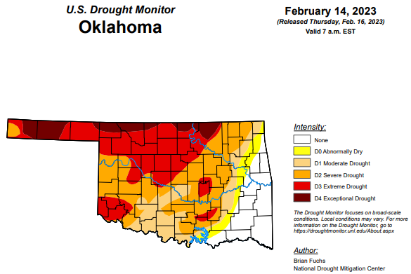
After a few weeks consisting of several parts of the state receiving some decent moisture, the drought monitor this week saw some substantial improvements add up into the extreme drought or worse and severe drought or worse categories. In fact, all categories of drought saw improvements this week.
To view the Oklahoma Drought Map, click here.
Exceptional drought or worse has improved by over three percentage points from 11.27 percent down to this week’s 8.07 percent.
Extreme drought or worse has jumped down to 36.58 percent from last week’s 56.20 percent.
Severe drought or worse has improved from last week as it moved from 79.25 percent to this week’s percentage of 66.94.
Moderate drought or worse has improved and is now at 80.07 percent, down from last week’s 84.95 percent.
Extreme drought or worse improved by almost ten percent as it jumped down to 85.03 percent this week- down from last week’s 94.12.
According to the 6 to 10-day precipitation outlook map, the panhandle and the northern half of the state are leaning above a 33 to 40 percent chance of precipitation through February 25. The southern half of the state is standing at a near-normal percent chance of precipitation through February 25.
To view the United States Drought Monitor Report, click here.
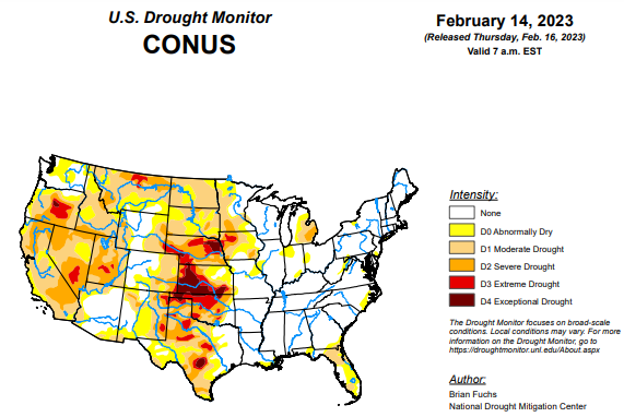
According to the latest U.S. drought monitor report, an active weather week over much of the South, Southeast and portions of the Midwest allowed many locations in eastern Oklahoma, northern Arkansas, central Mississippi, northern Florida, southern Georgia and into coastal areas of South Carolina to record above-normal precipitation. Dry conditions dominated the West and northern Plains. Temperatures were well above normal in the northern Plains and upper Midwest, with departures of 15-20 degrees above normal. Most areas east of the Missouri River were above normal for the week with departures of 5-15 degrees above normal common. Cooler-than-normal temperatures dominated the intermountain West and into the Four Corners region where temperatures were 5-10 degrees below normal for the week.
In the Southern Plains, precipitation was widespread throughout most of eastern Oklahoma, northern Texas, northern Arkansas and portions of southern Louisiana with most of these areas recording 150-200% of normal precipitation for the week. Temperatures were warmest in the eastern extent where Arkansas and Louisiana were 4-6 degrees above normal while most of Oklahoma and Texas were 2-4 degrees below normal. The recent wetter pattern allowed for most of eastern Oklahoma to observe a full category improvement to the drought intensities with abnormally dry conditions removed from the eastern extent and some exceptional drought improved as well. Areas of eastern Texas had improvements made to moderate drought and abnormally dry conditions but saw degradations, mainly on long-term indicators highlighting the changes over portions of the panhandle, central and south Texas.
In the High Plains, temperatures for the week were warmest over the eastern and northern extent of the region with departures 10-15 degrees above normal while the western areas were 5-10 degrees below normal in portions of Wyoming and Colorado. Most of the region was dry this week with the exception of eastern Kansas where over 200% of normal precipitation was recorded for the week. As temperatures warmed up and the benefits of the snowpack over portions of southern South Dakota and northern Nebraska started to be observed, improvements were made this week to the drought intensity levels along the South Dakota and Nebraska borders. A full category improvement was also made to conditions in eastern Kansas where more moderate drought was eliminated and improvements to severe and extreme drought were made in southeast portions of the state. Some slight degradation was introduced in Wyoming where severe drought was expanded in the east and southwest portions of the state.
In the West, cooler-than-normal temperatures dominated most of the region outside of Montana where temperatures were 15-20 degrees above normal for the week. Most of the region was dry with only portions of New Mexico, southern Colorado, southern Montana and portions of the Pacific Northwest recording above-normal precipitation. Snowpack over the region remains well above normal. With the continued wet pattern over the Southwest, portions of Arizona and New Mexico were improved this week with moderate drought and abnormally dry conditions reduced in both states. Drier conditions in Washington allowed for some expansion of abnormally dry conditions while a reassessment of the extreme drought in northwest Nevada determined that conditions had improved enough to remove all of the extreme drought in this region.
Looking ahead, over the next 5-7 days, a storm system will track out of the Four Corners region and onto the Plains, bringing with it widespread precipitation from Colorado, through the Plains and into the Midwest. Widespread precipitation is also expected throughout the South and into the Mid-Atlantic where up to 2-3 inches of rain is anticipated. Much of the southern and northern Plains as well as the West will be dry during this time. Temperatures are expected to be above normal over much of the southern Plains, Midwest and eastward with departures of 8-10 degrees above normal. Cooler-than-normal temperatures are expected over the central to northern Plains, and over the West where departures of up to 15 degrees below normal will be expected over Wyoming.
The 6–10-day outlooks show above-normal chances of below-normal temperatures over the northern Rocky Mountains, the Pacific Northwest and much of the West. The best chances of above-normal temperatures will be over the Southeast and through much of the South and Mid-Atlantic. Most of the country is showing above-normal chances of recording above-normal precipitation with the best chances over the Great Basin and in the Mid-Atlantic. South Texas and the peninsula of Florida are still showing a better likelihood of below-normal precipitation.
To view the 6-10 Day Precipitation Outlook Map, click here.
To view the 6-10 Day Temperature Outlook Map, click here.
To view the Monthly Drought Outlook Map, click here.


