

To view the Oklahoma Drought Map, click here.
**Rains this week will most likely be reflected in next week’s drought monitor**
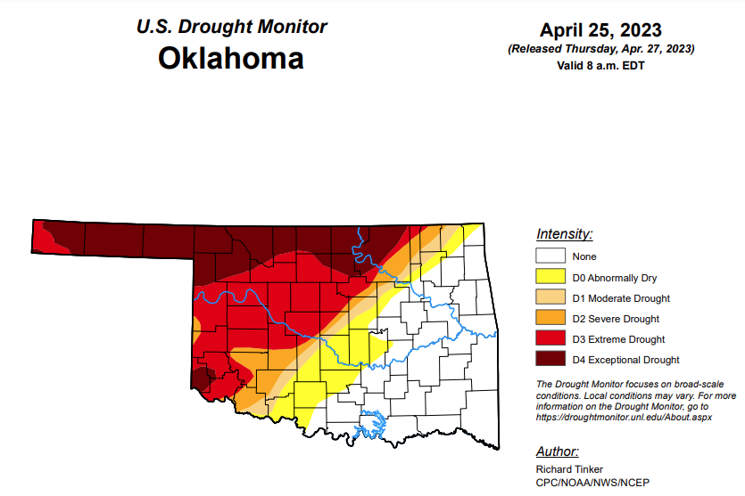
According to the latest Oklahoma Drought Map, Exceptional Drought is unchanged from last week’s 20.62 percent.
Extreme drought or worse is virtually unchanged from last week, moving from 43.03 percent to this week’s 43.19 percent.
Severe drought or worse is unchanged from last week, remaining at 49.87 percent.
Moderate drought or worse is unchanged from last week, remaining at 54.07 percent.
Abnormally dry or worse conditions have increased slightly from 63.57 percent to 64.52 percent.
According to the 6-10-day precipitation outlook map, the panhandle and southwestern Oklahoma are leaning above a 33 to 40 percent chance of precipitation through May 6. The remaining parts of the state are sitting at a “near normal” chance of precipitation through May 6.
To view the United States Drought Monitor Report, click here.
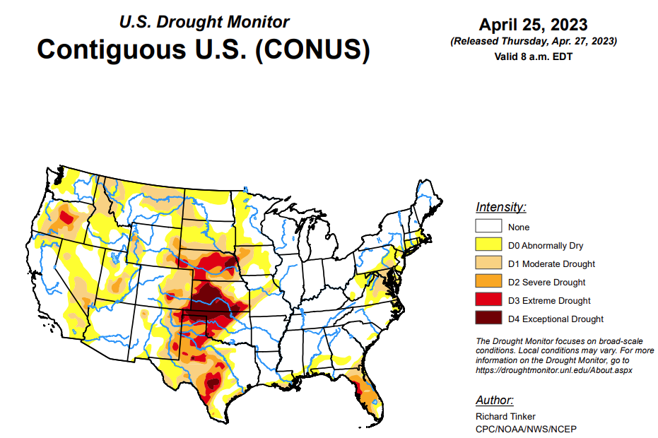
According to the latest U.S. Drought Monitor, heavy precipitation fell on areas of dryness in the Northeast, the southern and northern Plains, the northern Rockies, northern Intermountain West, and Pacific Northwest, and more-scattered areas in the mid-Atlantic Region and Florida. Enough rain fell on some extant areas of dryness and drought here to improve drought designations, including parts of the D3 and D4 areas in central to southern Texas. In contrast, the D3 to D4 areas in the rest of the Plains and the northwestern Florida Peninsula and recorded little or no precipitation, keeping extreme to exceptional drought in place with a few areas of deterioration, especially in central Nebraska and the northwestern Florida Peninsula.
In the Southern Plains, locations from eastern Texas and Oklahoma eastward through Mississippi and Tennessee remained free of any designation on the Drought Monitor, though a number of areas reported that short-term dryness – on the order of a few weeks – was becoming noticeable over northern stretches of this area. Thus dryness and drought were again limited to areas near the Gulf of Mexico and over central and western sections of Texas and Oklahoma.
Heavy rain eased dryness-related impacts over much of central and southern Texas. Several inches of rain in eastern parts of Deep South Texas allowed for 2-category improvements, with much of the area going from D1 last week to no designation this week. Still, large areas of D3 and D4 remained over central and western parts of Texas and Oklahoma, with more limited reductions occurring in these areas. But enough rain fell to pull D4 out of Bexar County, Texas.
To the north and west of central Texas, little or no rain fell this past week to the 8 am EDT April 25 valid period of the Drought Monitor, keeping conditions essentially unchanged in most areas, though some degradation was noted in small sections in west-central and northern Texas. Most of the northern tier of Oklahoma remains entrenched in exceptional (D4) drought, in addition to a few scattered areas farther south. According to the Department of Agriculture, 63 percent of Oklahoma winter wheat was in poor or very poor conditions, as was 55 percent of Texas winter wheat.
In the High Plains, the general pattern observed during the past few weeks continued. Unusually deep snowpack was melting in the central and northern Dakotas, leading to some improvements there, including the removal of all moderate drought (D1) from northern North Dakota.
In the Great Plains from central and western South Dakota southward through Kansas, the continued lack of substantial rainfall led to intensification over a relatively large part of these areas. In particular, D3 expanded through most of central Nebraska, and lesser expansion of D3 and D4 reported in central Kansas. To the west, conditions remained generally unchanged in eastern parts of Wyoming and Colorado, with deterioration (to D2) limited to a small area in southeastern Wyoming. In the other area of extant dryness and drought in western Wyoming – adjacent to Utah and Idaho – some areas saw improved conditions, as did states to the north and west.
The Department of Agriculture reported 62 percent of Kansas winter wheat in poor or very poor condition, as was 42 percent of Nebraska winter wheat. Only 7 percent of Colorado winter wheat was in very poor condition, but almost one-third of the rest of the state’s crop was in poor condition.
In the West, areas of moderate to heavy precipitation brought some improvement across western Oregon and portions of Montana, while melting of the deep snowpack farther south eased conditions in parts of southeastern Idaho, much of the western half of Utah, northeastern Oregon, and small patches in the southern Great Basin and Southwest. This included the removal of moderate drought (D1) from parts of northern California, continuing the trend of improvement there since heavy precipitation became a frequent occurrence starting in early December 2022. The only area in the West Climate Region that noticeably deteriorated was some D0 expansion in southeastern Montana, where conditions have been similar to those in the central and southern High Plains Climate Region.
Looking ahead, during the next five days (April 26 – May 1, 2023) moderate to heavy precipitation (over 1.5 inches) is expected along the southern tier of the Nation from Texas and the lower Mississippi Valley through central and northern Florida, and along the Eastern Seaboard from Georgia through New England. Parts of the Upper Peninsula in Michigan are also forecast to receive 1.5 or more inches. Very heavy precipitation (3 to 5 inches) are expected in part of northeastern Texas, the central Gulf Coast Region, and southern Georgia. In contrast, little or nothing is anticipated from the High Plains westward, over the central and northern Great Plains, parts of the middle Mississippi Valley, and the southern Great Lakes Region. Moderate to locally heavy precipitation was observed from the Colorado Rockies through the south-central Great Plains and adjacent areas shortly after the Drought Monitor valid period (8 am EDT Tuesday, April 25) ended, with over 1.5 inches observed in scattered areas of central Arkansas, near the Oklahoma/Kansas border, west-central Kansas, higher elevations in the Rockies, and isolated sites across northern Texas. This precipitation will be considered for the Drought Monitor valid May 2, 2023 (next week). Other areas in dryness or drought should see one-tenth to locally one inch. Below-normal temperatures are expected over the southern Great Plains and most of the eastern half of the contiguous states outside the immediate coast in the South Atlantic Region. Meanwhile, warmer than normal weather is anticipated from most of the Plains through interior sections of the West Coast States. Cooler than normal conditions are expected along most of the immediate Pacific Coastline.
The Climate Prediction Center’s 6-10 day outlook (valid May 2 – 6, 2023) Identifies enhanced chances for above-normal precipitation in most of New England, the lower Mississippi Valley, Texas, the southern half of the High Plains, and from the Rockies to the Pacific Coast (except northwestern Washington). Odds for significantly above-normal precipitation exceed 50 percent in the Great Basin, most of California, and some adjacent areas. In contrast, subnormal totals are favored in the Southeast, the lower mid-Atlantic Region, and from the central and southern Appalachians northwestward through most of the Ohio Valley, Great Lakes Region, northern half of the Mississippi Valley, the northern Plains, and the Upper Midwest. Enhanced chances for cooler than normal weather cover California and adjacent areas in the Southwest and Great Basin, and in most locations from the Mississippi Valley to the East Coast. Meanwhile, unusually warm weather is expected from the northern Rockies and Intermountain West through most of the Rockies and the southern half of the High Plains.


