

To view the latest Oklahoma drought map, CLICK HERE.
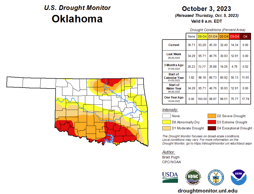
According to the latest Oklahoma Drought Monitor, Exceptional Drought remains at Zero percent, unchanged for the past few weeks.
Extreme drought or worse is now at 14.34, up from last weeks, 12.91 percent.
Severe drought or worse is now at 32.40 percent, up from last week’s 30.93 percent.
Moderate drought or worse is slightly better now at 45.30 percent, improved from last week’s 46.76 percent.
Abnormally dry or worse conditions are now at 63.29 percent, improved from last week’s 65.71 percent.
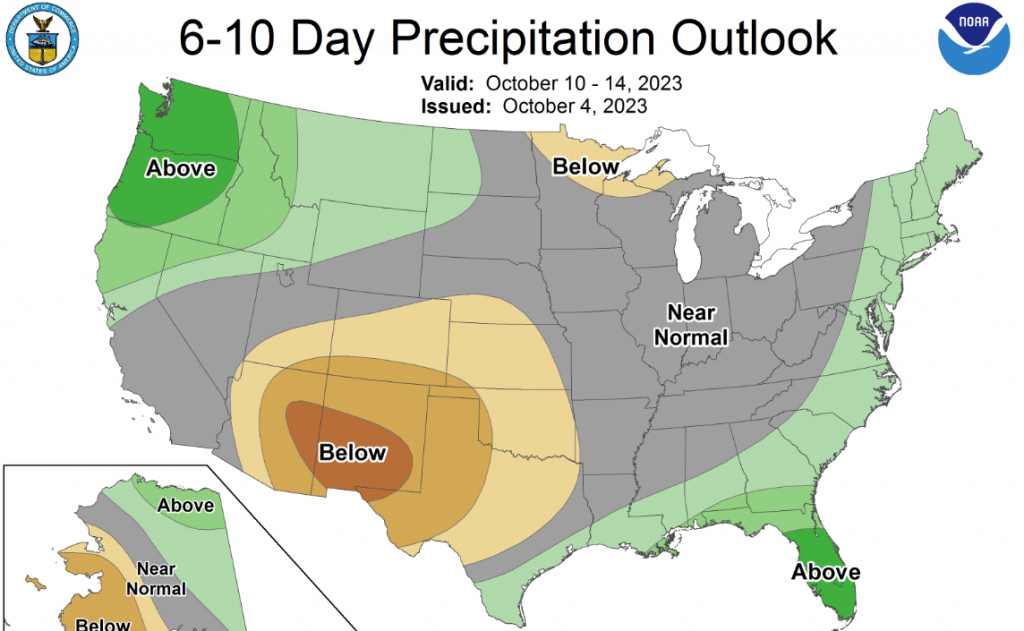
According to the 6-10 Day Precipitation Outlook Map, most of the panhandle and southwestern Oklahoma is leaning below a 40 to 50 percent chance of precipitation through October 14. The rest of the state is leaning below a 40 to 50 percent chance of precipitation through October 14.
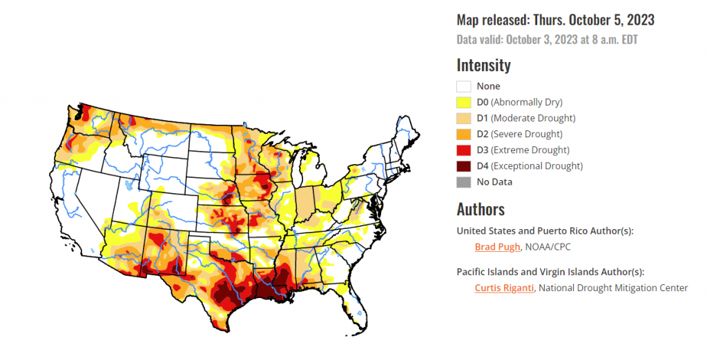
According to the latest US Drought Monitor Map, The rapid onset and intensification of drought continued across the South with drought expanding northeast from the Lower Mississippi Valley to the Tennessee Valley and Southern Appalachians. A drier-than-normal September expanded abnormal dryness (D0) and moderate short-term drought (D1) across the Upper Ohio Valley, Eastern Corn Belt, and western parts of Pennsylvania, New York, and West Virginia. Drought of varying intensity persists across the Middle to Upper Mississippi Valley and parts of the Great Plains. However, heavy rainfall at the beginning of October improved the Southern High Plains. A suppressed 2023 Monsoon intensified drought across Arizona and western New Mexico. Early fall precipitation began to ease drought along the coastal Pacific Northwest. Drought continues to worsen along the leeward side of Maui.
To view the United States Drought Map, click here.
In the Southern Plains, A broad 1-category degradation was made to the Lower Mississippi Valley and Tennessee Valley as 30-60 day SPI/SPEI, NDMC short-term blend, soil moisture, and impacts supported expanding/intensifying drought. Impacts in Mississippi include poor pasture conditions, soybean and peanut losses, and cattle sell offs. Severe (D2) to exceptional (D4) drought persists across much of Mississippi and Louisiana, while drought of varying intensity affects the Southern Great Plains. Heavy rainfall (more than 2 inches) on October 2nd supported a 1-category improvement across the Oklahoma Panhandle and western Texas. Based on state recommendations and consistent with the NDMC drought blends, the extreme drought (D3) was slightly reduced across western Texas.
in the Midwest A mix of degradations and improvements were made this past week across the Middle to Upper Mississippi Valley, Ohio Valley, and Corn Belt. The largest areas of degradation were focused across Indiana and Ohio where many areas have received less than 25 percent of their normal precipitation during the past 30 days and soil moisture indicators continue to decline. Based on NDMC’s short to long-term blends and soil moisture, extreme (D3) and exceptional (D4) drought was expanded across eastern Iowa. Parts of Kentucky, southern Illinois, Minnesota, and Wisconsin had a 1-category improvement after heavy rainfall (more than 1.5 inches) the previous week.
in the High Plains, Increasing 30 to 60-day deficits along with support from SPIs at various time scales and the NDMC’s short-term drought blend, a 1-category degradation was made to northeastern Kansas and southeastern Nebraska. Despite a mostly dry week across southern South Dakota, a reassessment of current indicators such as NDMC’s drought blends supported a decrease in abnormal dryness (D0) and moderate drought (D1) in that area. A 1-category degradation was made to northwestern Colorado, based on SPEIs at multiple time scales along with support from soil moisture and vegetation indicators.
In the West, Following the drier-than-normal Monsoon, a 1-category degradation was warranted for parts of Arizona and western New Mexico. Conversely, heavy rainfall (more than 2 inches) on October 2nd led to a 1-category improvement for parts of eastern New Mexico. NDMC’s short-term blend and soil moisture supported a 1-category degradation in eastern Utah. Extreme drought (D3) was improved to severe drought (D2) in parts of northern Montana based on indicators dating back 12 months. In addition, 28-day average streamflows are above the 5th percentile in northwestern Montana. During the past two weeks, coastal Oregon and the Puget Sound of Washington received 3 to 6 inches of precipitation which supported a 1-category improvement.
To view the 6-10 Day Precipitation Outlook Map, click here.
To view the 6-10 Day Temperature Outlook Map, click here.
To view the Monthly Drought Outlook Map, click here.


