

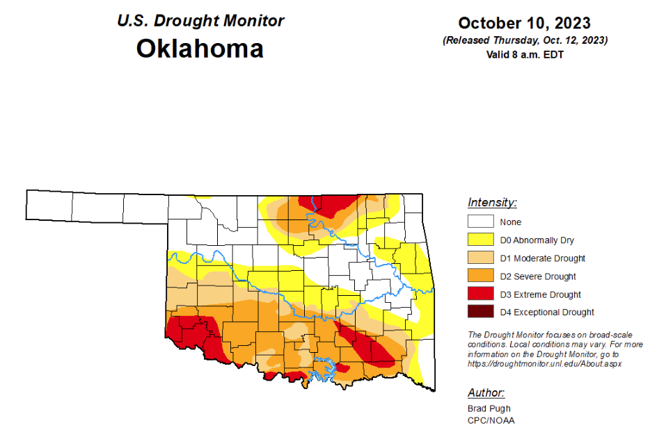
To view the latest Oklahoma drought map, CLICK HERE.
According to the latest Oklahoma drought monitor report, exceptional drought remains at zero percent, unchanged from the past few weeks.
Extreme drought or worse is now at 8.48 percent, down from last week’s 14.34 percent.
Severe drought or worse is now at 29.44 percent, down from last week’s 32.40 percent.
Moderate drought or worse is now at 43.11 percent, down from last week’s 45.3 percent.
Abnormally dry or worse conditions are now at 63.32 percent, up slightly from last week’s 63.29 percent.
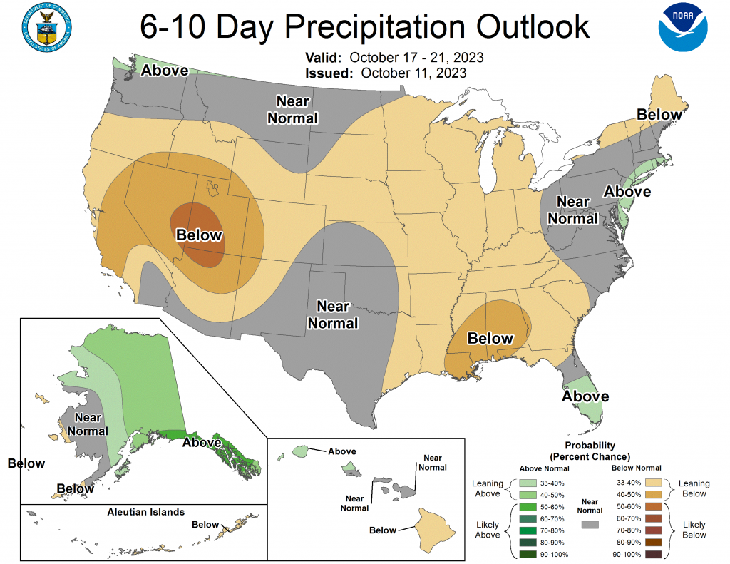
According to the 6-10-day precipitation outlook map, the majority of the state aside from the eastern border stands at a near normal chance of precipitation through October 21. As for the southern border, that part of the state is leaning below a 33 to 40 percent chance of precipitation through that October 21 date.
According to the latest U.S. Drought Monitor Report, a strong cold front resulted in moderate to heavy precipitation across the Great Plains, Ozarks, and western Gulf Coast during the first week of October. The most widespread improvements were made to southern Arkansas, northwestern Louisiana, southeastern Oklahoma, and eastern to central Texas where more than 2 inches of precipitation was observed this past week. Following anomalous heat across the central U.S. to start October, the cold front ushered in much cooler temperatures from October 5 to 7. The first frost or freeze of the fall affected the Northern to Central Great Plains on October 7. As the cold front progressed eastward, drought-easing rainfall overspread parts of Illinois, northern Indiana, southern Michigan, and western New York. Father to the south, short-term drought continued to expand north and east across the Southeast. Following a wet September, minor improvements were warranted for parts of Washington. Heavy rainfall, associated with Tropical Storm Philippe, resulted in improving drought for eastern Puerto Rico. Drought continues to intensify across parts of Maui and the Big Island.
To view the United States Drought Map, click here.
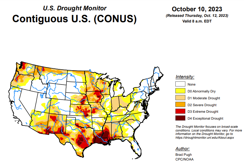
In the Southern Plains, a broad 1-category improvement was made to southern Arkansas, northwestern Louisiana, southeastern Oklahoma, and eastern to central Texas where more than 1.5 inches of precipitation occurred this past week. SPIs at multiple time scales, soil moisture, and 28-day average streamflows were also factors in determining where to depict the improvements. For areas that received more than 3 inches of precipitation and there was support from the NDMC’s drought blends, a 2-category improvement was justified across southwestern Arkansas, northeastern Texas, and the Texas Gulf Coast. Drought coverage and intensity across Texas peaked in early September when 85.68 percent of the state was covered with drought (D1 or higher) and two-thirds of the state was designated with severe (D2) to exceptional (D4) drought. Based on 90-day SPEI, an expansion of D2-D4 was made to parts of Mississippi. Impacts in Mississippi include poor pasture conditions, soybean and peanut losses, and cattle sell offs. The 90-day SPEI also supported an expansion of D4 across northeastern Louisiana. Increasing short-term dryness led to an expansion of abnormal dryness (D0) and moderate drought (D1) across Tennessee.
In the High Plains, 1-category improvement was made to northwestern North Dakota and northeastern South Dakota where more than 1 inch of precipitation occurred this past week. Small improvements were also warranted in central Nebraska with the wet start to October. Although parts of eastern Nebraska also received heavier precipitation, NDMC’s long-term blend supports D2+ levels of drought. Based on drier-than-normal conditions during the past 60 days and soil moisture, abnormal dryness (D0) was expanded across the southwestern corner of Nebraska. 60-day SPI, soil moisture, and NDMC’s short-term blend supported an increase in D0 and the addition of D1 across southern Wyoming. The suppressed 2023 Monsoon and the 6-month SPEI supported an expansion of D2 in southwestern Colorado, while increasing short-term dryness led to increasing D0 coverage across northwestern Colorado.
In the West, 1-category improvement was made to northeastern Montana where more than 1 inch of precipitation occurred this past week. Precipitation during the past two weeks along with long-term SPIs supported the removal of extreme drought (D3) in north-central Montana. Based on SPI at multiple time scales, severe drought (D2) was added to eastern Arizona while there was an expansion of moderate drought (D1) in western Arizona. Improving 28-day streamflows along with support from NDMC’s short to long-term blends led to a 1-category improvement for the Puget Sound of Washington along with southeastern parts of the state. Abnormal dryness (D0) was expanded across northeastern Utah due to increasing short-term dryness during the past one to three months and this was also consistent with changes made to adjacent Colorado and Wyoming.
Looking ahead, during the next five days (October 12-16, 2023), an intense low pressure system is forecast to track from the Central Rockies and Great Plains eastward to the Midwest and Central Appalachians. A swath of heavy precipitation (1 to 3 inches) is likely to accompany this surface low. On October 12th, a vigorous area of mid-level low pressure is expected to bring heavy snow (6 to 12 inches) to the higher elevations of Wyoming. A low pressure system is forecast to move offshore of the Southeast by October 13th after it brings widespread precipitation to parts of the Southeast. Mostly dry weather is forecast to persist across the Tennessee Valley, while much drier weather prevails across the Southern Great Plains. Periods of light to moderate precipitation are expected for the coastal Pacific Northwest.
The Climate Prediction Center’s 6-10 day outlook (valid October 17-21, 2023) favors near to below-normal precipitation throughout much of the contiguous U.S. with above-normal precipitation most likely across southeastern Alaska. Increased probabilities for above-normal temperatures are forecast across the West and Northern to Central Great Plains, while below-normal temperatures are likely for the Mid-Atlantic and Southeast.
To view the 6-10 Day Precipitation Outlook Map, click here.
To view the 6-10 Day Temperature Outlook Map, click here.
To view the Monthly Drought Outlook Map, click here.


