


Oklahoma Wildfires Burn 150,000+ Acres; Gary McManus Warns of New Red Flag Danger
The wildfire crisis in Oklahoma has reached a critical threshold, with state officials and meteorologists sounding the alarm as the destruction mounts. According to Oklahoma State Climatologist Gary McManus, the toll is staggering: over 150,000 acres have already been consumed, resulting in destroyed homes, mandatory evacuations, and injuries to firefighters on the front lines. Governor Kevin Stitt has declared a State of Emergency for Beaver, Texas, and Woodward counties as multiple wildfires continue to burn across northwest Oklahoma.

McManus warns that while the state has already faced a “significant, high-impact” fire event, the danger is far from over. “We get to do the same thing today, and again tomorrow,” McManus noted in his latest update, highlighting a relentless weather pattern.
The Atmospheric Setup
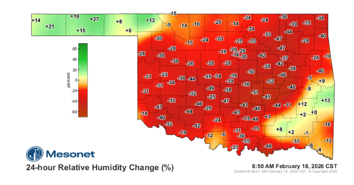
While wind speeds are expected to be lower than previous days, McManus points to a secondary atmospheric threat: plummeting humidity. The passage of a “dryline” has already “primed the pump” for further fire activity.
The primary driver of today’s risk is the relationship between temperature and moisture. As temperatures rise, the air’s capacity to hold moisture increases, but the actual amount of water vapor (the dewpoint) remains extremely low. This causes relative humidity (RH) levels to drop to dangerous levels.
- Central Oklahoma: RH values are expected to drop as low as 14%.
- Eastern Oklahoma: Even typically humid regions are seeing forecasts near 18%.
Fuel Receptivity and Fire Behavior
The Oklahoma Forestry Services (OFS) reports that the state is experiencing “near-continuous burning periods.” This occurs when overnight moisture recovery is so poor that fires do not “lay down” or slow their spread during the night.
Gary McManus shared insights from OFS regarding the current state of “fuels” (vegetation):
- Extreme Receptivity: Grass, brush, and range fuels are bone-dry and ready to ignite.
- Rapid Spread: Fully established fires will exhibit rapid rates of spread even with lighter winds due to the volatility of the fuels.
- Access Challenges: Paradoxically, some areas that received rainfall last weekend have wet ground beneath dry surface fuels, which can trap heavy firefighting equipment.
The Forecast Ahead

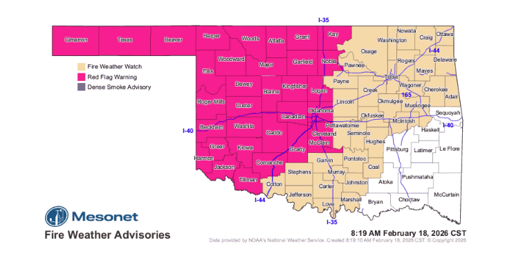
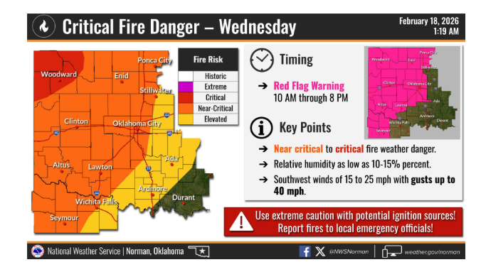
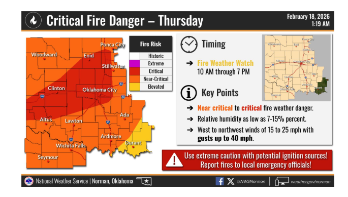
The window of danger remains wide open. A Red Flag Warning is in effect for the western half of the state through this evening. Looking toward tomorrow, a Fire Weather Watch has been issued for most of the state, with expectations that it will be upgraded to a Red Flag Warning as even drier air moves in.
The hope among officials is that today’s lighter winds will provide a brief window for crews to gain containment on existing fires before the next wave of extreme fire weather arrives tomorrow.
To see what resources are needed and how you can help, click here:
To read more from Gary McManus on his mesonet ticker, click here:


