

The climatological winter of 2025–2026 has officially entered the record books as the warmest in Oklahoma history, leaving a trail of intensified drought and devastating wildfires in its wake. As the state transitions into March, State Climatologist Gary McManus suggests the current Oklahoma Weather week could serve as a “make-or-break” turning point for the parched landscape.
A Historic Winter Heatwave
Data from the Oklahoma Mesonet confirms that February 2024 ended with a statewide average temperature of 51.1 degrees, shattering the previous 1954 record of 50.6 degrees. This exceptional warmth capped off the warmest winter since records began in 1895, with a three-month average of 44.3 degrees.
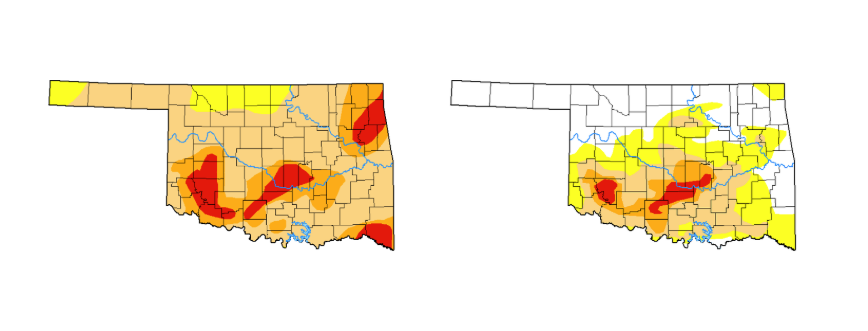
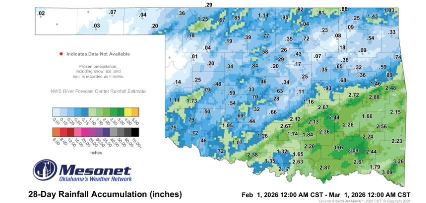
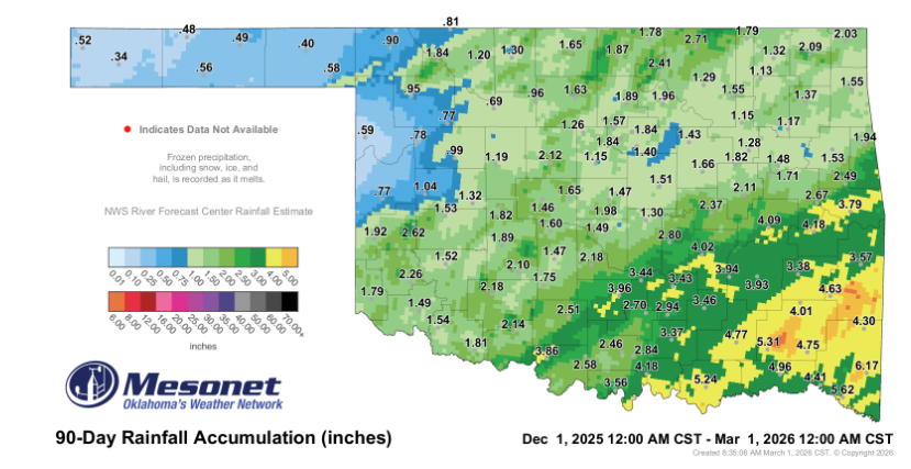
The lack of moisture accompanying this heat has been equally historic. The state saw its seventh-driest winter on record, with an average precipitation of only 2.13 inches—more than 3 inches below normal. These conditions allowed drought to spread across 92% of the state by late February, the highest coverage seen since late 2022.
Wildfire Outbreak and Severe Potential
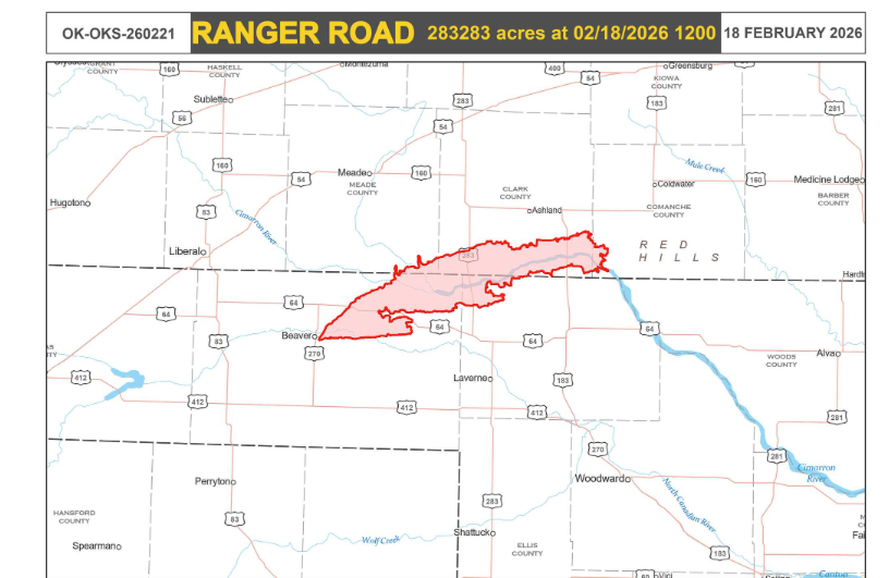
The combination of record heat and deepening drought proved volatile in mid-February. On Feb. 17, wind gusts reaching 70 mph fueled a massive wildfire outbreak. The Ranger Road Fire alone scorched over 280,000 acres across Oklahoma and Kansas, while several other blazes forced evacuations in Woodward, Texas, and Beaver counties.
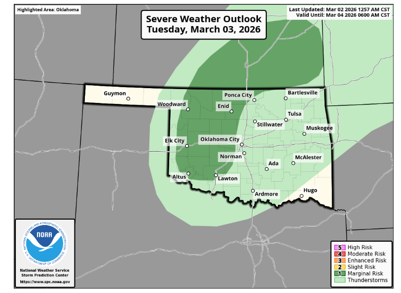
Active Week: Storms, Hail, and Fire Risk
While the heat has been the primary story, the transition to March is introducing a volatile weather pattern. Residents are urged to remain “weather aware” as severe storm chances persist almost daily this week.
- Tuesday Warmup & Storms: After a cool Monday, temperatures are expected to spike into the upper 70s and low 80s on Tuesday. This heat, combined with gusty southerly winds, will create elevated fire weather conditions in Western Oklahoma before thunderstorms develop late in the evening.
- Severe Potential: The Storm Prediction Center has highlighted a Marginal Risk for Tuesday night, with isolated rotating storms capable of producing large hail and damaging winds.
- Mid-Week Outlook: Storm chances continue Wednesday as a cold front moves through. “We’ll see those severe storm chances almost every day this week in some part of the state, and as we know in Oklahoma, things can change in a hurry,” McManus noted.

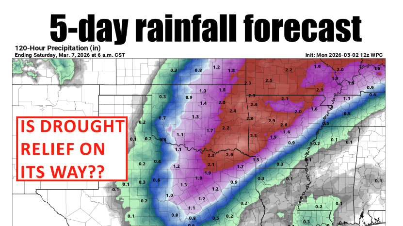
The Drought’s “Make-or-Break” Moment
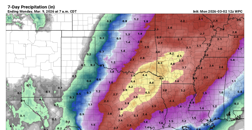
For a state desperate for moisture, the 7-day rainfall forecast offers a glimmer of hope, though the hit-or-miss nature of thunderstorms makes the outcome uncertain.
“This week is sort of a make-or-break episode for the drought that we’ve seen continuously spreading and intensifying since August,” McManus said. “Just depends on where that rain falls, and who gets enough to make a difference.”
The primary concern remains whether the moisture will reach the hardest-hit areas in Western Oklahoma.
“Can western Oklahoma really expect to get anything at all, given the track record of the drought? I’m hopeful!” McManus noted. “I think there will be a sharp cutoff, but where exactly will that cutoff be?”
March Outlook
The Climate Prediction Center (CPC) offers an optimistic outlook for the remainder of the month. While above-normal temperatures are expected to persist, there are increased odds for above-normal precipitation, particularly in the northeastern half of the state. The CPC outlook suggests potential drought removal for large portions of Oklahoma, though the Panhandle and far northwest may see drought conditions persist.
Winter by the numbers
- Statewide average temperature: 44.3°F, 4.1°F above normal — the warmest
Winter since records began in 1895 - Temperature extremes: High of 89°F at Mangum on Christmas Day; low of –12°F
at Kenton on Jan. 26; lowest wind chill, –24°F at Kenton on Jan. 26 - Statewide average precipitation: 2.13 inches, 3.24 inches below normal — the
seventh-driest winter since 1895 - Rainfall extremes: High of 6.17 inches at Broken Bow; low of 0.34 inches at
Boise City
As Oklahomans keep an eye on the sky this week, the OCS/Mesonet Ticker will continue to track whether this “exciting” weather shift provides the relief the agricultural community and fire crews desperately need.
To read more from State Climatologist Gary McManus on his mesonet ticker, click here:


