

Oklahoma Forestry Services (OFS) is monitoring a “dual threat” weather pattern today as a dryline establishes itself across the Oklahoma and Texas Panhandles. This setup creates elevated fire weather conditions west of the boundary, while rain and storm chances are expected to develop to the east throughout the afternoon and evening.
Current reports indicate that while the Northeast, East-Central, and Southeast areas have seen no new activity, one fire outside of the initial attack area burned 106 acres. Additionally, suppression efforts continue on the West Creek (41 Road) Fire in Woodward County, which has burned 341 acres and is now 90% contained.
Regional Breakdown and Fire Behavior
- Oklahoma Panhandle and Northwest: Poor overnight moisture recovery will lead to an early start for the burning period. Officials are particularly concerned about dry lightning potential in the Panhandle, where fuel moisture levels are between 3% and 5%. Rangeland fuels in this area could see head fire rates of spread between 120–180 ft/min with flame lengths reaching 13 feet.
- Western and Southwest Oklahoma: Higher dewpoint temperatures may prevent relative humidity from dropping as low as in previous days, but storm development this afternoon brings the risk of lightning ignitions and erratic fire behavior. In these regions, rangeland fuels may exhibit rates of spread up to 170 ft/min.
- North-Central and Northeast: Temperatures remain in the 80°s, but higher humidity and increasing cloud cover should keep fuel moisture above 7%. While fire danger is present in heavy grass loadings, increasing rain chances this evening are expected to settle concerns.
- South-Central and Southeast: Following recent rainfall and higher humidity (>50%), fire danger remains limited for most of the region. Any new fire activity is unlikely to exceed a rate of spread of 75 ft/min.
Statewide Discussion and Outlook
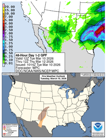
The Quantitative Precipitation Forecast indicates that the best potential for wetting rainfall has shifted further south over the next two days. As this weather system passes, dry conditions are expected to return, coupled with a drier-than-normal outlook for the next ten days.
A strong cold front is forecasted to move through the state early Wednesday morning, bringing cooler temperatures. However, dry and windy post-frontal conditions may prompt elevated to near-critical fire weather across western and northwestern Oklahoma tomorrow.
OFS Resource Mobilization
Suppression groups, including engines, dozers, and overhead support, are currently stationed in the following areas to respond to new ignitions:
- Guymon
- Elk City
- Stillwater
- Eastern OFS Areas (Resources available as needed)
Farm Director KC Sheperd notes that while transitional “green up” in yards and roadsides may help limit some fire potential in central and eastern regions, the threat remains high in the west.


