

To view the latest Oklahoma drought map, CLICK HERE.
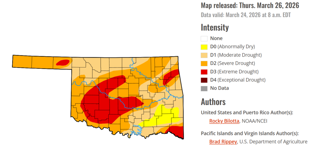
Drought conditions continue to grip much of Oklahoma, with nearly 94% of the state affected and extreme drought expanding sharply in recent days. The most concerning shift is the growth of extreme drought, now covering over 22% of the state—a significant jump from just a week ago. Still, there’s some cautious optimism ahead, as upcoming forecasts show increasing chances of rainfall that could begin to bring much-needed relief.
According to the latest Oklahoma Drought Monitor report, exceptional drought remains at 0 percent, unchanged from the start of the calendar year.
Moderate drought to extreme drought conditions in the current period indicate that 94.29% of the state is affected by drought same as last week.
Extreme Drought conditions have grown considerably this week, now covering 22.49% of the state, a 8.99% increase from a week ago, affecting mainly Blaine, Tillman, Pottawatomie, Seminole, McClain, Garvin, Stephens, Kiowa, Washita, Delaware, Ottawa, Mayes, Cherokee, McCurtain, and parts of surrounding counties.
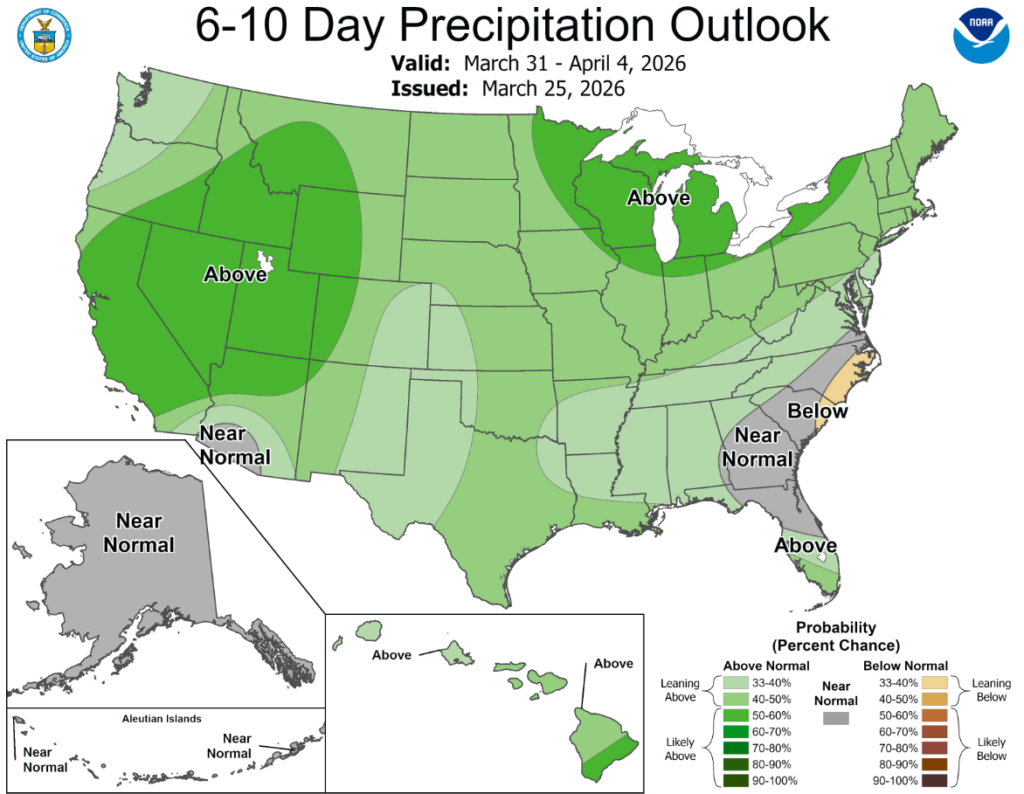
According to the 6-to-10-day precipitation outlook map, central Oklahoma is leaning above 40-50% chance of precipitation while western Oklahoma is leaning above 33-40% chance of precipitation through April 4th.
This week, extreme weather events across the United States painted a starkly contrasting picture of drought development and relief. In the West and Plains, a persistent heat dome drove temperatures 20 to 25 degrees above normal, shattering early-season records and significantly increasing evaporative demand. This intense heat, combined with high winds and pre-existing dryness, threatened to rapidly deplete topsoil moisture and fueled explosive, landscape-altering wildfires—most notably the historic Morrill Fire in Nebraska that consumed over 800,000 acres. Ultimately, the combination of soaring temperatures and below-normal precipitation resulted in the expansion of drought and abnormal dryness across portions of the West, Great Plains, and parts of the Southeast. Conversely, other regions experienced abrupt and volatile moisture influxes that mitigated dry conditions but introduced localized to severe flooding. In the Pacific Northwest, an atmospheric river stalled over Washington, bringing heavy rain and significant snowmelt. Further east, a powerful winter storm delivered a massive precipitation boost in the form of a late-season blizzard, dropping over 50 inches of snow across parts of the Upper Midwest and Michigan’s Upper Peninsula. The most extreme precipitation of the week occurred over the Hawaiian Islands, where a stalled Kona low dumped unprecedented, historic rainfall, resulting in excessive flooding, widespread landslides, and infrastructure damage. Overall, above-normal precipitation resulted in improvements to drought and abnormal dryness across parts of the Midwest, Northeast, Hawaii, and Puerto Rico.
In The South: Hot and dry conditions dominated the South this week, driving widespread drought degradation. Temperatures soared 5 to 20 degrees F above normal across the vast majority of the region. This heat was coupled with persistent dryness, as month-to-date rainfall deficits grew to 1 to 3 inches below average (representing only 5% to 50% of normal). Deteriorating short- and long-term indicators justified the introduction and expansion of exceptional drought (D4) in southern Texas and northern Arkansas. Extreme drought (D3) was introduced in the Oklahoma Panhandle and expanded across central Oklahoma, northern Arkansas, southern Texas, and Louisiana. Additionally, severe drought (D2) worsened across parts of Oklahoma, Texas, Arkansas, Louisiana, and Tennessee, while moderate drought (D1) and abnormal dryness (D0) expanded in Texas, Mississippi, and southern Louisiana.
In the High Plains: Intense, unseasonable warmth gripped the High Plains, with temperatures soaring up to 25 degrees F above normal, peaking in parts of Wyoming and Colorado. Precipitation was nearly non-existent, particularly across the southern half of the region. This severe, persistent dryness, coupled with rapidly deteriorating drought indicators, forced widespread expansion and intensification of drought categories. Exceptional drought (D4) expanded in northwest Colorado, while extreme drought (D3) grew across Colorado, southern Wyoming, and southern Nebraska. Severe drought (D2) pushed further into central and northern Wyoming, western and southern Colorado, and advanced from Nebraska into South Dakota. Moderate drought (D1) and abnormal dryness (D0) also expanded broadly across Wyoming, Colorado, Nebraska, and Kansas. No drought improvements were made in the High Plains this week.
In the West: Anomalous warmth dominated the West, with nearly the much region seeing temperatures 15 to 25 degrees F above normal. Precipitation was largely absent, save for beneficial moisture in parts of Washington and Montana. This localized precipitation allowed for the reduction of severe drought (D2) in central Montana and abnormal dryness (D0) in western Washington. Elsewhere, the combination of soaring temperatures, lacking precipitation, and declining soil moisture and streamflow data resulted in broad drought degradation. Extreme drought (D3) expanded in southern Idaho, central and northeastern Utah, and northwest New Mexico. Severe drought (D2) increased in coverage across Oregon, southern Idaho, southern Montana, southern and eastern Utah, southern and eastern Arizona, and New Mexico. Finally, abnormal dryness (D0) expanded in eastern Oregon and central and southern California.
To view the 6-10 Day Precipitation Outlook Map, click here.
To view the 6-10 Day Temperature Outlook Map, click here.
To view the Monthly Drought Outlook Map, click here.


