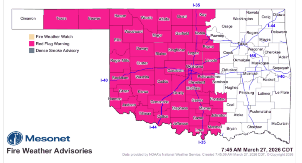
Fire danger remains the primary concern for Oklahomans today as a powerful cold front has pushed through the state, bringing intense post-frontal winds that are challenging control lines on numerous active wildfires. A Red Flag Warning is in effect through this evening for most of central and western Oklahoma, where wind gusts could reach as high as 55 mph.
The Oklahoma Department of Agriculture, Food & Forestry (ODAFF) reported significant fire activity over the last 24 hours, with 12 fires burning over 2,000 acres across the Northeast, East Central, and Southeast areas. Many of these fires were caused by incendiary activity or escaped control burns. Currently, Oklahoma Forestry Services (OFS) resources are engaged in several large-scale suppression efforts, including the Big Toe Fire in Pittsburg County at 1,208 acres and the Iron Post Fire in Cherokee County at 1,304 acres.
According to the latest situation report, composite fuel moisture continues to degrade, making fires in brush and timber especially difficult to contain. While cooler temperatures and cloud cover are providing some moderation, the extremely dry fuels and high winds are producing fire behavior that is resistant to control.
Regional Breakdown of Today’s Threat:
- Western and Southwest Oklahoma: Residents should expect northeast winds of 20-30 mph with gusts up to 55 mph. In these conditions, rangeland fires can spread at speeds of 3.5 to 4 mph with flame lengths reaching 22 feet. Mixed fuels may exhibit extreme behavior, including short crown runs and spotting up to a quarter-mile.
- Oklahoma Panhandle and Northwest: Northerly winds will gust up to 50 mph today. With relative humidity values as low as 17%, any fire that becomes established in rangeland fuels has the potential for extreme rates of spread.
- North-Central and Northeast: Despite some very light morning rainfall, it will have minimal effect on fire behavior. Winds gusting to 35 mph will support rapid grass fire spread and flame lengths over 20 feet.
- South-Central and Southeast: Heavier cloud cover will shade fuels, but established wildfires will still exhibit problematic behavior. Wind gusts above 30 mph will support rapid rates of spread in grassland and timber.
Looking ahead to Saturday, a return to southerly winds and humidity levels around 20% will perpetuate the enhanced fire danger. While rain chances are in the forecast for next week, they are currently focused on far eastern Oklahoma, leaving the central and western regions of the state vulnerable to repetitive dryline intrusions and continued fire weather.
OFS has mobilized suppression groups including engines, dozers, and overhead teams in Woodward, Fairview, Guthrie, Stillwater, and Henryetta to respond to new starts and maintain the integrity of existing control lines.