

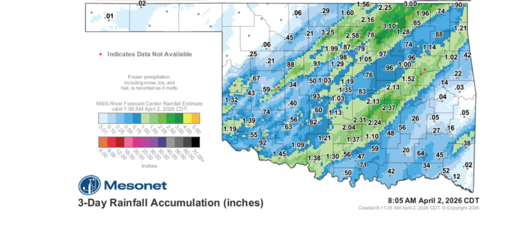
While the threat of severe weather often looms large over the state, Oklahoma’s most recent storm system took a different, more welcome path. State Climatologist Gary McManus noted that the day resulted in a relatively ordinary Oklahoma weather event, trading major destruction for much-needed rainfall relief.
“And I know a lot of folks got left out (I see you, NW OK!), but I know we all want to celebrate the rest of us that DID get some good rain,” McManus said. “And on top of that, there was very little in the way of severe weather. The day ended up, at least as far as I can tell, as sort of an ordinary Oklahoma severe weather day. Some wind, some hail, and lots of rain in places.”
Resetting the Maps
The influx of moisture is a critical development for a state that has seen a major expansion of drought conditions recently. McManus highlighted that these rains are beginning the process of “resetting” the visual depictions of drought across Oklahoma.
“Enough so that we’re starting to reset some of these ugly maps,” McManus said.
Current drought intensity has been driven not just by lack of rain, but by record heat sustained over the previous nine months. This combination of heat and dryness led to requests for the expansion of D4 drought conditions—the highest intensity level—across Southwest and Central Oklahoma.
“I actually requested an expansion of D4 across SW into central OK where I felt the conditions had escalated to that highest intensity level due to the record heat over the last 9 months to go along with the dry weather, but that was denied so we’ll hope for rainfall instead,” McManus said.
The Timing of the Drought Monitor
Understanding the progress of drought recovery requires a look at how the data is collected. The U.S. Drought Monitor operates on a specific weekly cycle. McManus noted that all this moisture comes in the “Greg of time,” noting that the U.S. Drought Monitor runs on a Tuesday a.m.-to-Tuesday a.m. time frame.
“So any rains that fell after Tuesday of this week will be reflected on next week’s map,” McManus said.
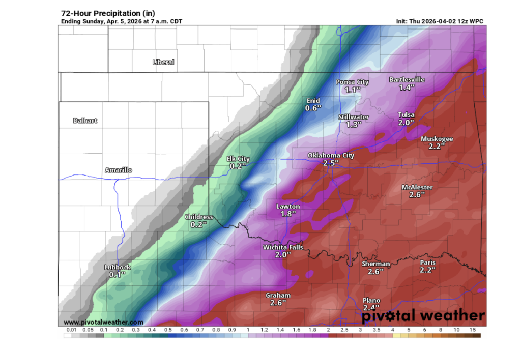
More Moisture on the Horizon
The reprieve is not over yet. Another storm system is projected to move through the state this Friday, offering a second chance for moisture. However, the distribution of rain remains uneven.
“But fret not (okay, feel free to fret), because we have another storm coming in on Friday that will bring the state more rain,” McManus said. “Those in NW OK get left out again, it appears (hence the fretting).”
Despite the current dry spell in the panhandle and surrounding areas, McManus remains optimistic about the seasonal shift.
“Don’t worry, even in NW OK, spring will live to fight another day,” McManus said.
To see more from Gary McManus on his mesonet ticker, click here:


