

While much of Oklahoma is seeing a reprieve from wildfire activity due to recent rainfall, critical fire weather conditions have prompted a Red Flag Warning for Cimarron County today. According to Oklahoma Forestry Services (OFS), a Fire Weather Watch is also in effect for Friday across the entire Panhandle as a dryline intrusion threatens to elevate fire danger.
Regional Fire Activity and Current Conditions
Recent reporting indicates minimal new activity across the majority of the state. The Northeast and East-Central areas reported no new fires, while the Southeast area saw three fires burning a total of 38 acres. These were attributed to one escaped controlled burn and two incendiary causes.
In the Oklahoma Panhandle and Northwest regions, the focus remains west of Guymon. Forecasters anticipate temperatures between 73°F and 77°F with relative humidity dropping to 20%. These conditions will result in fine-dead fuel moisture levels as low as 3% to 4%. South-southwest winds are expected to intensify this afternoon, reaching sustained speeds of 22–26 mph with gusts up to 40 mph.
Fire Behavior Outlook
In areas of average rangeland fuel loading, wildfires could see rapid spread rates of 260–335 feet per minute (approximately 3.3 mph) with flame lengths reaching 15–19 feet. In areas with exceptional fuel loading, the rate of spread may exceed 350 feet per minute.
“Any established fire will prove resistant to control and large fire potential has increased again,” the OFS report stated regarding the western Panhandle.
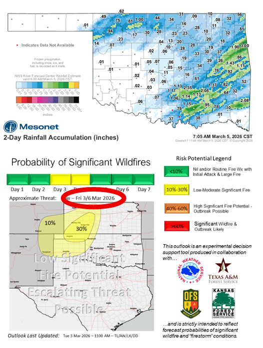
Impact of Rainfall and Storms
Rain and storm chances continue to moderate fire danger for the bulk of the state:
- Western/Southwest Oklahoma: Heavy cloud cover and moist air are limiting fine fuel receptiveness. However, lightning remains a concern for new ignitions, with potential for “holdover” fires that could emerge when the dryline arrives on Friday.
- North-Central/Northeast: Rainfall has effectively negated wildfire concerns for today, shifting the focus toward storm potential.
- South-Central/Southeast: Solidly wetting rain amounts have eliminated short-term wildfire concerns in these regions.
Looking Ahead to Friday
A “bimodal weather threat” is developing for Friday as a dryline moves into the western tier of counties. This will create a split weather pattern: critical fire weather potential to the west of the dryline and severe storm potential to the east.
Specific concern is noted for the Panhandle, particularly in the vicinity of the recent Ranger Road Fire and along the Beaver River in Texas and Beaver counties, where very dry air and strong southwest gusts are expected to align.


