

Oklahoma Forestry Services (OFS) is monitoring a significant increase in fire receptiveness today as a low-level thermal ridge develops over the northwestern portion of the state. While much of the eastern tier remains under a reduced threat due to recent moisture, a surge of very dry air and well-above-normal temperatures is creating challenging conditions for western and north-central Oklahoma.
Current Fire Activity and Mobilization
According to the OFS Fire Department Wildfire Cost Reporting Tool, one large fire is currently seeing active resources:
- West Creek (41 Road) Fire: Located in Woodward County, this blaze has burned approximately 299 acres and is currently 45% contained.
In response to the elevated risk, OFS has positioned suppression groups—including engines, dozers, and overhead personnel—in Guymon, Woodward, and Elk City. Additional resources remain available from eastern OFS areas if needed.
Regional Breakdown of Fire Conditions
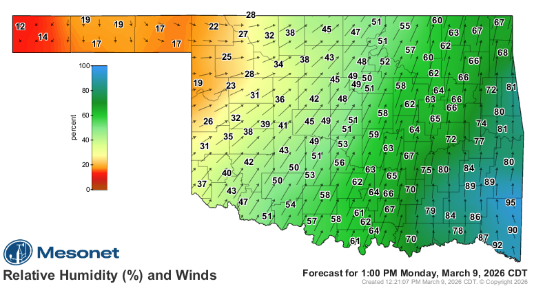
The primary concern today involves a “thermal ridge” pushing single-digit relative humidity into the Panhandle and western Oklahoma. This dry air, combined with fine-dead fuel moisture levels as low as 2%, is expected to result in an extended burning period tonight as moisture recovery lags.
Oklahoma Panhandle and Northwest
Expect an early start to the burning period due to poor overnight moisture recovery. Temperatures will reach 80°–85°F with relative humidity between 6–15%. Southwest winds of 9–13 mph (gusts to 20 mph) will drive head fire rates of spread between 130–195 ft/min, with flame lengths averaging 13 feet. Mixed fuels may exhibit problematic behavior, including tree torching and short-range spotting.
Western and Southwest Oklahoma
Drying conditions from previous days have primed the landscape for rapid fire spread. Temperatures are forecast to hit the mid-80s to near 90°F along the Red River. Winds will increase late this afternoon, sustained at 15–20 mph with gusts up to 30 mph. Rangeland fuels could see spread rates of 150–205 ft/min.
North-Central and Northeast Oklahoma
Areas near the I-35 corridor where recent rainfall was spotty are seeing an uptick in initial attack activity. Highs in the mid-80s and humidity as low as 15% will support grassland spread rates of 140–192 ft/min during peak burning hours.
South-Central and Southeast Oklahoma
This region remains the least vulnerable today. Lingering cloud cover and morning showers will keep humidity levels above 30%. While it remains warm, grass-dominated fuels are not expected to exceed spread rates of 110 ft/min, allowing for successful initial attack efforts.
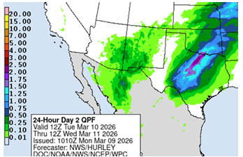
Looking Ahead: Rain Chances and Post-Frontal Risks
According to Farm Director KC Sheperd, there is a silver lining in the forecast for Tuesday. Increasing chances for rain and storms are expected, with the highest probability of “wetting” amounts (significant rainfall) occurring south of the I-44 corridor.
However, the fire danger is not entirely over. Fire weather elements are forecast to return Wednesday through Friday. The level of concern for late-week fire activity in western and central Oklahoma will depend heavily on exactly how much rain falls during Tuesday’s storms.


