
Relief may finally be in sight for Southern Plains fall weather as a major atmospheric pattern shift prepares to break persistent drought conditions and relentless triple-digit heat. Farm Director KC Sheperd recently sat down with AccuWeather Senior Meteorologist Chad Merrill to discuss what agricultural producers can anticipate as empty soil profiles challenge upcoming winter wheat planting and pasture establishment across Oklahoma, Texas, and Kansas.
Addressing the ongoing flash drought conditions, Merrill highlighted that relief is on the horizon, though patience will be required in the immediate future.
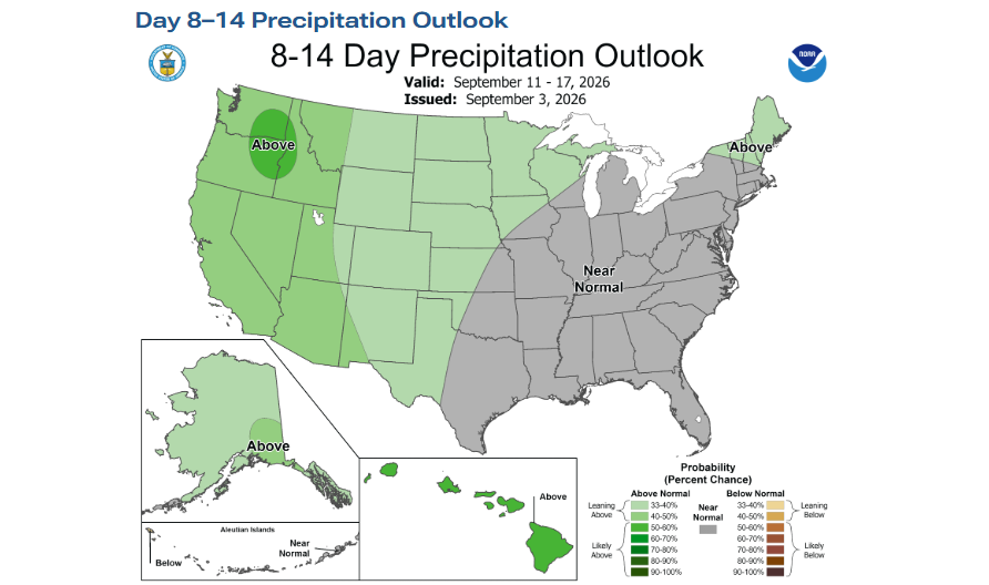
“You know what, it’s dry all across the Plains and all across the northwestern part of the Corn Belt,” Merrill said. “This flash drought that got started several weeks ago basically has continued through the early part of September. And, you know, looking ahead, it’s going to be hot, it’s going to be dry here for about the next two weeks, and then we should start to see a pattern change at the end of the month.”
The breakdown of the stubborn weather ridge dominating the region will clear a path for incoming storm tracks.
“The heat dome that’s been in place across the Plains and the Southeast is going to start to break down about week three of September,” Merrill explained. “What that’s going to allow is the storm systems that come in from the southwestern part of the country to finally move into places like Texas, Oklahoma, and Kansas and provide some cooling relief and the opportunity for showers and thunderstorms to start to chip away at the drought.”
He pointed out that this shift directly aligns with agricultural needs heading deeper into autumn.

“We’re thinking that it really does pick up—the moisture does pick up late September, into October, and November,” Merrill noted. “So, by November, there should be some chipping away of the drought that’s in place, and we do expect that precipitation will be above average for the fall season and it gets off to a good start here in late September. So, a good deal of moisture should trim away the moderate to severe drought that’s in place, and then by the end of November, we should see even some wholesale changes to the drought across the southern part of the Plains.”
Along with moisture, temperatures are projected to settle back into comfortable ranges after months of record summer highs.
“We are going to see temperatures very close to average when you combine September, October, and November,” Merrill said. “Obviously, the strong anomalies going through the early part of the fall season here in the first two weeks of September means that it has to be offset by significant cooling during the second part of the fall season to get those average temperatures down near the 30-year baseline… instead of having temperatures constantly over 100 degrees, you’ll have temperatures more like in the 70s and 80s through the middle part of the fall season.”
The driving engine behind this projected moisture increase is a strengthening El Niño pattern in the Pacific Ocean, which is displaying sea surface temperature anomalies running higher than those seen during the historic 1997 event.

“It’s a very strong El Niño, very east-based across the equatorial Pacific,” Merrill observed. “So with these very warm waters, combined with the fact that we have a marine heatwave off the coast of Southern California, and we have a stripe of water from Hawaii to Southern California that continues to run above average… it is just fueling this huge, massive area of very warm water in the East Pacific that is really allowing the El Niño to continue to develop. And what that’s going to do through the fall season is really ramp up the subtropical jet stream and allow low-pressure centers to bring a good bit of moisture into the Southwest and the southern part of the Plains states.”
Merrill added that these setups can cause sudden changes, warning producers to be mindful of flash flooding risks.
“Some of these low pressures can pick up moisture from tropical storms and hurricanes that are in the East Pacific and help to enhance the rain as that low pressure moves into the Southwest and eventually the Plains,” he stated. “So, there will be some downpours and some flooding opportunities as well. Could be one of those whiplash-type weather patterns where it’s hot and dry right now, and then you go bam right into a period of some heavy rain and flash flooding.”
Globally and nationally, an active El Niño triggers diverse weather conditions. While wet weather reaches the Southwest, Southern California, and parts of Southeast Asia, regions such as the northern U.S. Corn Belt, Canada, and Australia often turn much drier.
Regarding winter weather risks such as damaging ice storms, Merrill offered reassurance based on climatological records of past strong events.
“Typically, the subtropical jet stream is much stronger than the polar jet, so there are usually fewer intrusions of Arctic air that come into the country,” Merrill explained. “And if there is a blast of cold air, it’s usually during the very latter half of the winter season. And usually it takes those Arctic outbreaks to push all the way into Texas and Oklahoma for those areas to get significant icing. So, with a very strong El Niño event, it’s more going to be rain versus snow because those Arctic outbreaks are going to be, most likely, far and few between… there are far fewer icing events than a neutral ENSO or La Niña.”
For operations managing field work, Merrill cautioned producers to watch the timing of these dynamic systems closely.
“You need to time out the spacing between the showers and storms to get out in the fields,” Merrill advised. “Also, pay attention to how much rain is going to fall, because the rain rates in some of these storms could be high enough to cause some flooding… Even on a dry ground, if you get rain rates of two inches per hour, that’s going to cause some flooding on the fields because the water just can’t trickle through the soil.”
He also warned that dynamic southern systems during late fall and winter can bring more severe thunderstorm activity, gusty downslope winds, and localized power disruptions rather than arctic flash freezes.
Merrill recommended that producers leverage digital meteorological tools like the AccuWeather app to track regional precipitation amounts, short-term trends, and lightning alerts, alongside resources such as the NOAA Weather and Hazards Data Viewer to monitor incoming Pacific moisture tracks. Producers can also use these resources as well:
NWS Weather and Hazards Data Viewer and Oklahoma Weather Radar | AccuWeather and Oklahoma City, OK Recent Lightning | AccuWeather and Current Weather Conditions Map | AccuWeather
And a few key points to the fall outlook: AccuWeather 2026 United States Fall Forecast