

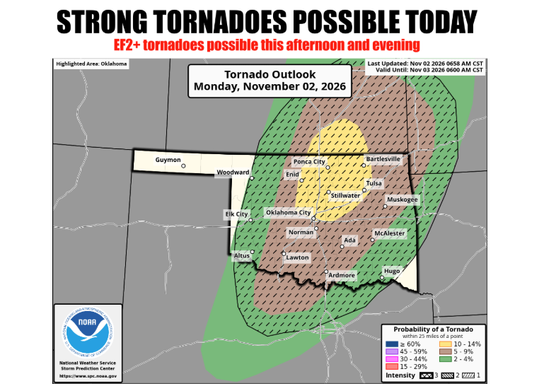
A dynamic late-autumn storm system is threatening Oklahoma with severe weather and tornadoes, closely following an exceptionally warm October that delivered significant, albeit uneven, drought relief across the state.
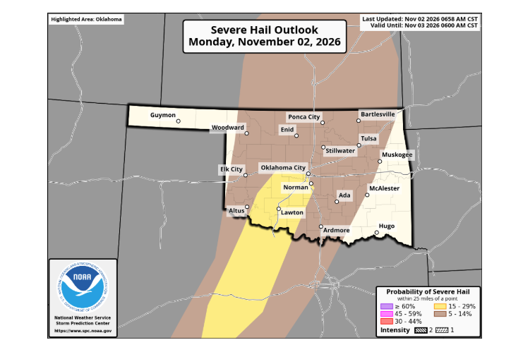
According to State Climatologist Gary McManus with the Oklahoma Mesonet and Oklahoma Climate Survey, conditions across the region are mirroring spring patterns rather than typical November weather. Atmospheric instability and strong wind shear are setting the stage for thunderstorms capable of producing large hail, destructive winds, and tornadoes.
Severe Weather Outlook and Timeline
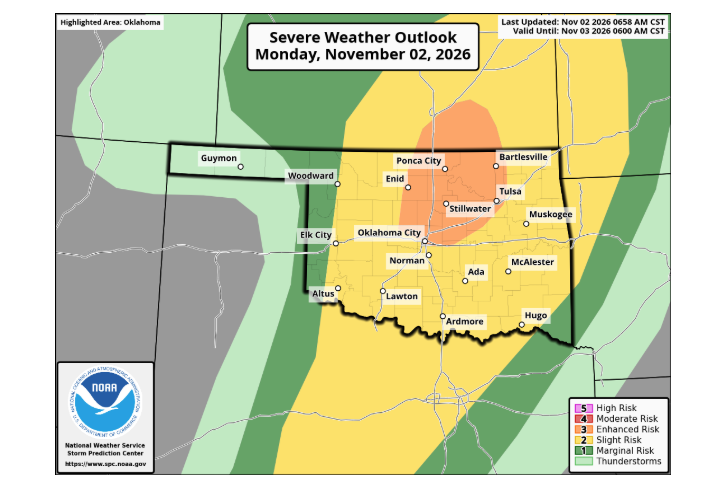
The Storm Prediction Center has placed portions of Oklahoma under an Enhanced Risk (Level 3 of 5), indicating a 10% probability of a tornado occurring within 25 miles of any given point in the risk zone.
An intensifying system tracking out of the Southwest is colliding with unseasonably warm, humid air over Oklahoma. A sharpening dryline in western Oklahoma serves as the lifting mechanism for storm initiation.
The progression of storms is expected along the following timeline:
Western Oklahoma: Severe activity is projected to initiate between 4 p.m. and 6 p.m. Central Oklahoma: Storms are expected to track into central counties between 6 p.m. and 9 p.m. Eastern Oklahoma: Severe hazards will persist eastward through the late evening and overnight hours.
Initial storm development may remain discrete, favoring supercells capable of producing large hail, damaging winds, and tornadoes. North-central Oklahoma into southern Kansas faces the greatest tornado threat, where low-level wind fields near sunset could support strong tornadoes of EF2 intensity or higher. If storms quickly congeal into a linear complex, damaging straight-line winds will become the primary threat, though embedded tornadoes will remain possible. With early November sunsets, residents are urged to maintain multiple reliable methods for receiving overnight warnings.
October Climate Summary: Widespread Rains Trim Drought
The severe threat follows an October characterized by heavy localized downpours that provided the state’s first sustained relief since flash drought expanded in August.
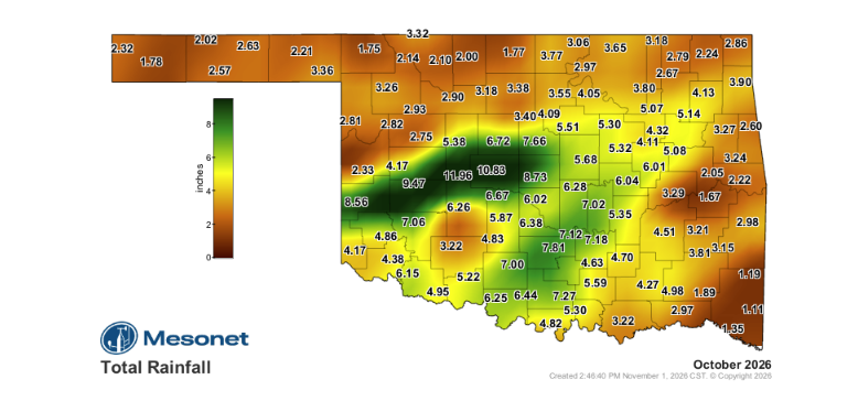
Preliminary Oklahoma Mesonet figures indicate a statewide average precipitation of 4.42 inches for October, which is 1.06 inches above normal and ranks as the 25th-wettest October since records began in 1895.
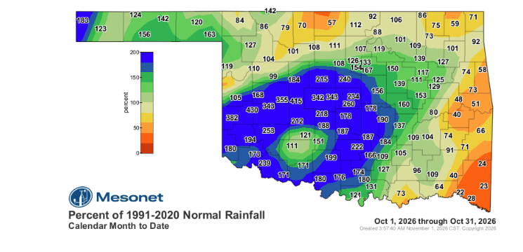
Corridors from west-central into central Oklahoma recorded rainfall totals between two and four times their monthly normal, generating surpluses of 6 to 9 inches. Hinton led Mesonet locations with 11.96 inches, including 8.71 inches on Oct. 14. An observing network site near Hydro recorded a monthly total of 15.98 inches, bolstered by 11.00 inches on Oct. 14—the fourth-highest single-day October rainfall total on record in Oklahoma. Conversely, far southeastern and eastern areas missed the heaviest precipitation, with Valliant recording just 1.02 inches for the month.
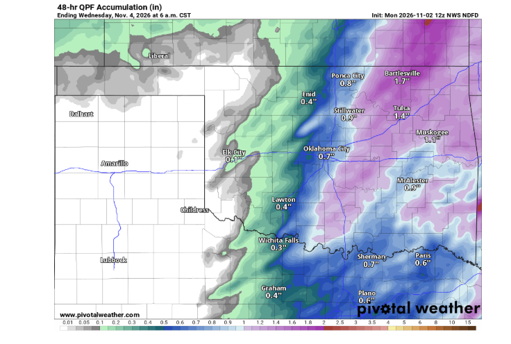
The heavy runoff caused flash flooding, washing out sections of Route 66 near Hydro and temporarily closing U.S. 81 and State Highway 3 in Kingfisher County.
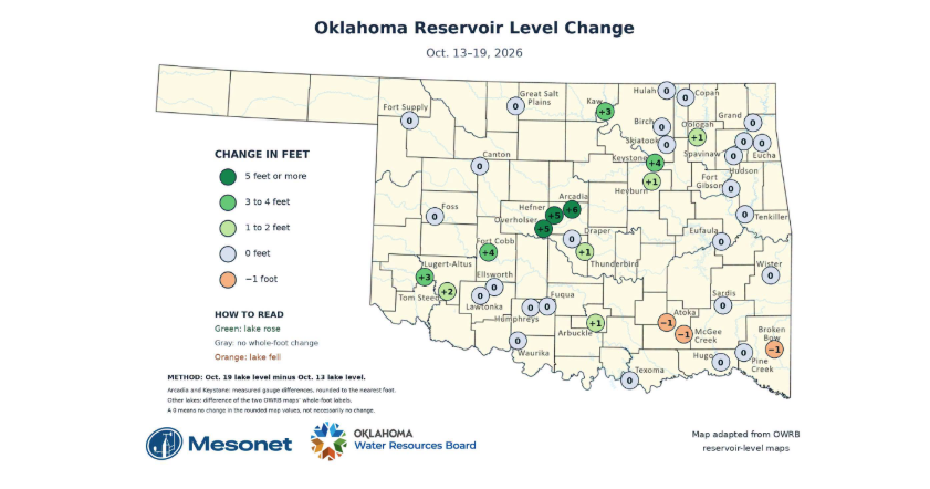
Despite the localized flooding, the rainfall significantly aided reservoir levels and soil profiles. Lake Arcadia rose approximately 6 feet between Oct. 13 and Oct. 19, while Lakes Hefner and Overholser each rose roughly 5 feet, returning both to near-normal pool elevations. Soil moisture improvements extended up to two feet below the surface across western and central sections of the state.
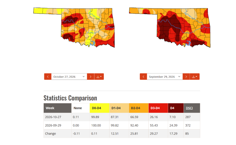
The U.S. Drought Monitor reflected these gains: Combined extreme and exceptional drought dropped from 55% coverage in late September to 26% by late October. Exceptional drought shrank from 24% to 7%. Moderate to severe drought continues to affect 87% of the state, as eastern areas and reservoirs like Lugert-Altus lag behind in recovery.
Persistent Heat Positions 2026 for Records
Despite significant rainfall, temperatures remained far above seasonal norms. The statewide average temperature for October finished at 67.0°F—5.7°F above average—marking the fifth-warmest October on record.
When paired with September, the two-month period established a new record for Oklahoma’s warmest September–October stretch, averaging 74.8°F (7.8°F above normal). Every climate division in the state registered its warmest September–October on record.
For the year to date, the statewide average temperature from January through October stands at 68.5°F, which is 5.0°F above normal and 2.1°F higher than the previous record pace set in 2012. The season’s first freeze was recorded on Oct. 16 across western Oklahoma, with Kenton, Eva, and Hooker dropping to freezing or lower.
October State Climate Statistics
Statewide Average Temperature: 67.0°F (5.7°F above normal; 5th-warmest October since 1895) Temperature Extremes: Monthly high of 96°F at Fairview on Oct. 13; monthly low of 27°F at Beaver, Eva, and Hooker on Oct. 17 Heat Index Peak: 105°F at Broken Bow on Oct. 13 Wind Chill Minimum: 19°F at Eva on Oct. 17 Location Averages: Highest monthly average at Idabel (70.0°F); lowest at Boise City (60.7°F) Statewide Average Precipitation: 4.42 inches (1.06 inches above normal; 25th-wettest October since 1895) Precipitation Extremes: Monthly maximum of 15.98 inches near Hydro; minimum of 1.02 inches at Valliant
November Climate Outlook
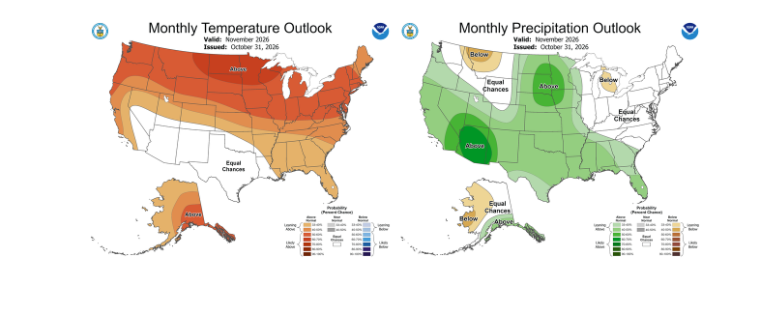
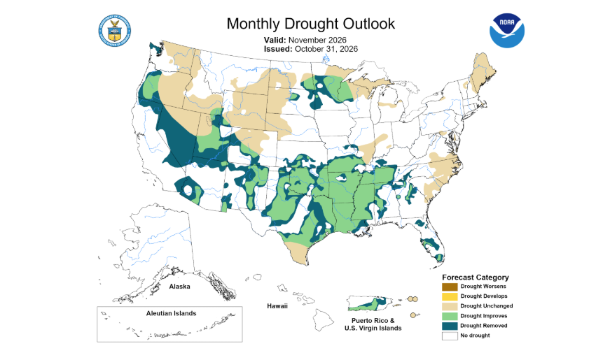
The Climate Prediction Center outlook for November points toward continued drought improvement. Supported by an active southern storm track driven by El Niño, the forecast favors above-normal precipitation statewide. Temperatures are tilted toward warmer-than-average conditions across northern Oklahoma, with equal chances of above-, near-, or below-normal temperatures across southern portions of the state. To see more from Gary McManus on his mesonet ticker, click here: