Thu, 15 Sep 2022 14:32:13 CDT
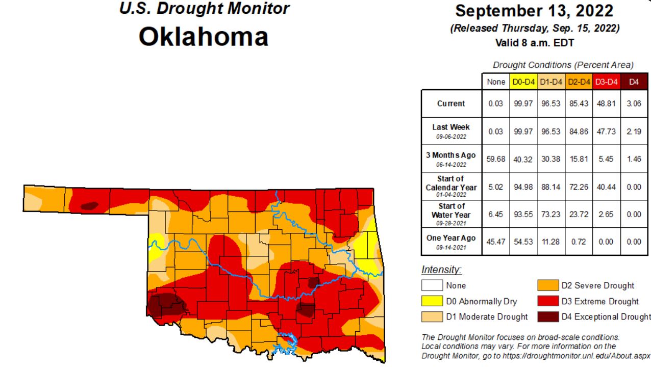
Warmer temperatures with little rain chances have increased drought numbers throughout the state. State Climatologist Gary McManus says there’s not much rain relief in sight, and the forecast calls for highs in the upper 90’s throughout the next 10 days. Mostly warmer and drier weather is in store.
In Oklahoma This week 3,660,659 are affected by drought, 77 counties currently have USDA Disaster designations. Greer, Harmon, Jackson, and Parts of Kiowa county are in the exceptional drought category, along with Coal, Hughes, and parts of Pontotoc county.
This week 3.06 percent of the state is in the Exceptional Drought category compared to Last weeks 2.19, while last year at this time we had zero drought reported in the state. 48.81% are in Extreme Drought compared to last weeks 47.43%, and 0% one year ago. 85.43% of the state is experiencing Severe Drought, last week that number was 84.86%. Moderate drought consumes 96.53% of the state, while 99.97% is abnormally dry. Moderate drought, and Abnormally Dry conditions remained the same.
To view the Oklahoma Drought map, click here:
This U.S. Drought Monitor (USDM) week saw areas of isolated heavy rainfall in Southern California and the Desert Southwest in association with remnant moisture from Tropical Cyclone Kay late last week. Over the weekend and early this week, the residual moisture from the system moved further onshore impacting areas including Southern California, southern Sierra Nevada, Desert Southwest, and portions of the Great Basin. Overall, the heaviest accumulations were observed in very isolated higher-elevation areas of the Peninsular Ranges and Transverse Ranges of Southern California with accumulations ranging from 3 to 5-inches in addition to reports of wind gusts between 70-100 mph. Unfortunately, the overall impact of the precipitation on the long-term drought in California was negligible. In the High Plains, above-normal temperatures (2 to 6 deg F) and generally dry conditions during the past week continued to exacerbate drought conditions across areas of the central and northern Plains, with a growing number of drought impacts within the agricultural sector being reported to the National Drought Mitigation Center. In Texas, areas of isolated heavy rainfall accumulations (3 to 5+ inches) this week continued to ease drought-related conditions in the Rio Grande Valley and South Texas. In the Midwest, widespread heavy rainfall accumulations ranging from 2 to 6+ inches impacted northern Illinois and southern Wisconsin over the weekend—erasing some of the short-term precipitation deficits. Elsewhere in the region, a combination of short and longer-term precipitation deficits in Iowa led to degradation on the map, with rainfall deficits during the past 90-day period ranging from 4 to 8+ inches in southern Iowa. In the Northeast and Mid-Atlantic states, widespread shower activity this week helped to improve drought-related conditions in the southern portion of the Northeast region as well as alleviate short-term (past 30-60 days) precipitation deficits in areas of the Coastal Plain and Piedmont of North Carolina. In the Southeast, most of the region remained drought-free with exception of coastal areas of east-central and southern Florida, where rainfall deficits for the past 90-day period ranged from 4 to 12+ inches, causing some concerns regarding hydrologic drought (some low groundwater and surface water levels) with the end of the wet season approaching. Looking back at the 2022 summer months, the contiguous U.S. experienced its 3rd warmest June-August period on record since 1895 in terms of average temperatures (+2.52 deg F anomaly). Average minimum temperatures nationwide for August (+3.20 deg F) and the July-August (+3.12 deg F) periods were the warmest on record, according to NOAA National Centers for Environmental Information (NCEI). Precipitation in the contiguous U.S. during August and the July-August 2022 period ranked at 19th and 28th wettest, respectively, placing it in the top 1/3rd wettest.
In the Southern plains improvements were made across isolated areas of Mississippi, Tennessee, and Texas. Degradations were made on the map in areas of Oklahoma, where rainfall deficits during the past 90-day period ranged from -3 to -7+ inches. According to the Oklahoma Mesonet, the last 90-days were the 7th driest statewide with a -4.79-inch departure from normal (50% of normal). During the past week, rainfall accumulations across the region were generally light (
In the High Plains On this week’s map, degradations were made in areas of Kansas, Nebraska, South Dakota, and North Dakota in response to continued dryness, decreased soil moisture, poor pasture and rangeland conditions, and impacts to dryland crops. In Kansas and Nebraska, the latest 7-day streamflow levels were showing widespread well-below-normal flows, especially in Nebraska. In southern Nebraska, numerous gaging stations on rivers and creeks were observing flows in the 1st to 2nd percentile range, according to the U.S. Geological Survey. For the week, average temperatures were above normal in the Dakotas (1 to 4 deg F) while Nebraska, eastern Wyoming, and Kansas were near normal to slightly below normal. According to NOAA NCEI, the Great Plains Region saw its 5th warmest (+2.7 deg F) and 19th driest June-August on record. Statewide, Nebraska experienced its 3rd driest June-August as well as its 2nd driest August on record.
Out West, numerous large wildland fires are currently burning across areas of California, Oregon, and Idaho causing evacuations, damage to structures, and reduced air quality. On this week’s map, some improvements were made in southeastern California, southern Nevada, and New Mexico in response to rainfall this week associated with residual moisture from Tropical Cyclone Kay as well as the overall impact of this summer’s monsoonal rainfall that has helped improve short-term meteorological drought conditions and vegetation health. Elsewhere in the region, a combination of short and long-term dryness, low streamflow, and declining soil moisture led to intensification of drought in areas of Montana and Idaho. For the week, average temperatures were 2 to 10+ degrees above normal across California, the Great Basin, northern portions of Arizona and New Mexico, and portions of the Pacific Northwest. Conversely, cloud cover associated with the remnants of Kay reduced daytime heating in the southeastern deserts of California and southern portions of Arizona and New Mexico, where average temperatures were 2 to 6 degrees below normal. According to NOAA NCEI, the June-August 2022 period was the 3rd warmest on record for the West Climate Region, which includes California and Nevada. Additionally, in terms of average minimum temperatures, both August (+5.6 deg F) and the July-August (+4.8 deg F) periods were the warmest on record. Looking at precipitation, it was the 8th wettest August on record for the West Climate Region and the driest (-6.95 inches) January-August period on record. For the Southwest Climate Region, it was the 7th wettest June-August period on record and the 7th warmest for the contemporaneous period. In the Northwest Climate Region, August (+6.2 deg F) and the July-August (+5.3 deg F) period were the warmest on record.
To view the Contiguous U.S. Drought Map, Click Here.
Looking ahead, The NWS WPC 7-Day Quantitative Precipitation Forecast (QPF) calls for moderate-to-heavy precipitation accumulations ranging from 2 to 4+ inches across areas of the Upper Midwest, with the heaviest amounts expected in Upper Peninsula Michigan and northeastern Minnesota. Likewise, 2 to 4+ inch accumulations are expected across areas of Florida. Elsewhere, lesser accumulations ranging from 1 to 2+ inches are forecasted for northern portions of New England as well as areas out West including the Northern Rockies, Wasatch Range, eastern Great Basin, and portions of the Southern and Central Rockies. The CPC 6-10-day Outlooks calls for a moderate-to-high probability of above-normal temperatures for all areas east of the Rockies, while much of the West is expected to be cooler than normal with exception of coastal areas of California. Precipitation is forecasted to be above normal across much of the West. Below-normal precipitation is expected across most of the Eastern Tier.
To view the 6 – 10 Day Precipitation Outlook, Click Here.
To view the 6 – 10 Day Temperature Outlook, Click Here.
To view the Monthly Drought Outlook map, Click Here.
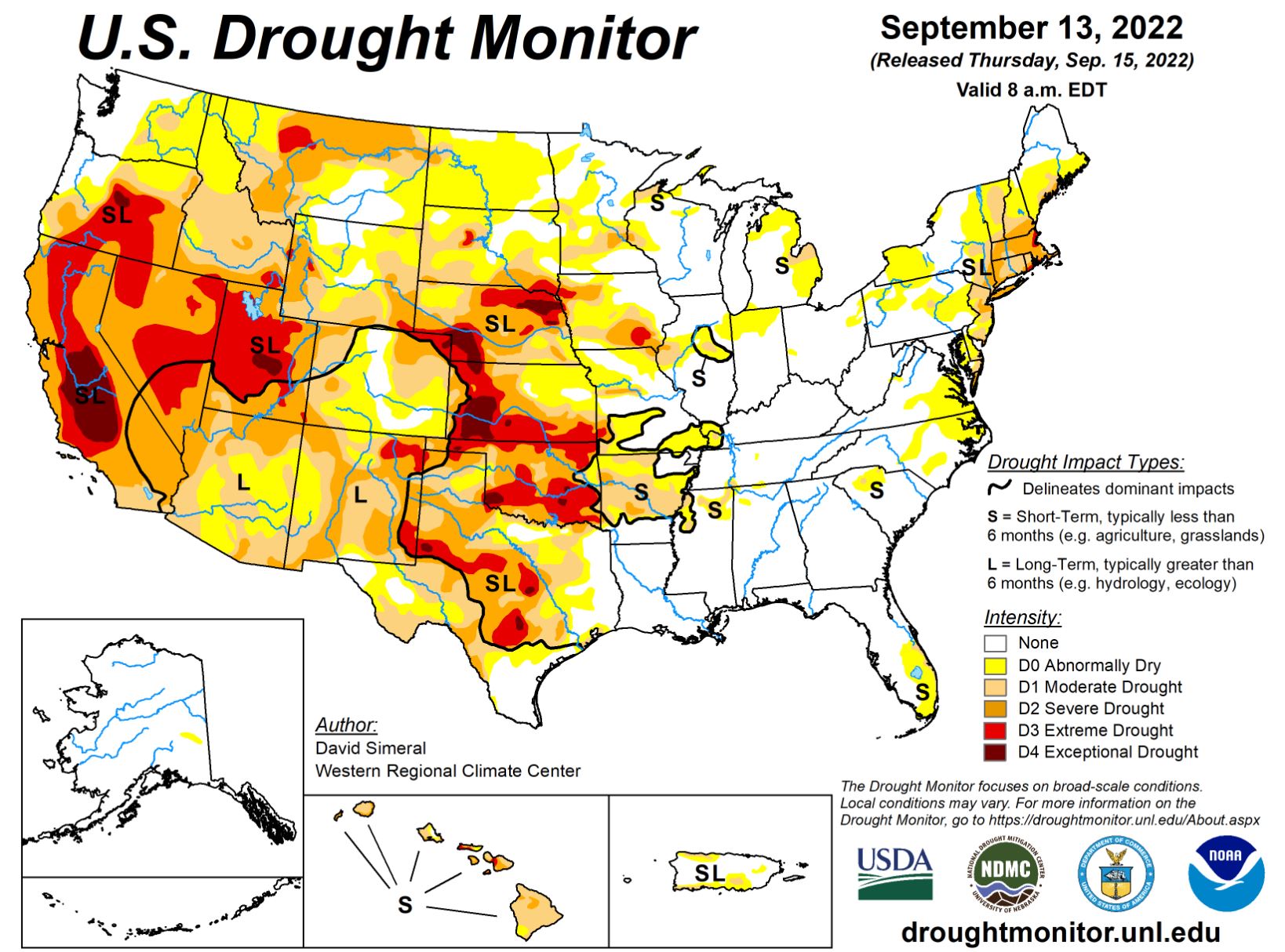
?The U.S. Drought Monitor Map is developed through a partnership between the National Drought Mitigation Center at the University of Nebraska-Lincoln, the United States Department of Agriculture, and the National Oceanic and Atmospheric Administration.