

Statewide Discussion: A brief warming trend through the weekend into Monday will support some increased fire danger leading to potential for increasing initial attack occurrence. No critical fire weather is expected over dormant fuels limiting large fire occurrence potential. The strongest alignment of fuels and fire weather will develop each afternoon generally along, north and west of I-44
Today: Following a chilly start, temperatures will warm into the upper-40°’s to mid-50°’s west and 40°’s to low-50°’s east.
Afternoon relative humidify values will be lowest in the Panhandle counties where 18-26% observations and fine-dead fuel moisture values are expected at 5-6% with the main body of the state generally 29-37% and afternoon FDFM at 7%. Generally light and variable winds this afternoon will limit fire spread potential providing very good opportunity for initial attack success. Head fire rates of spread in grass-dominated fuels generally less than 90 ft/min.
Saturday: Fire behavior potential will increase into the afternoon hours especially north/west of I-44 with increasing winds overavailable dormant fuels. Sky cover is expected to gradually increase through the day into the evening hours.
• North/West of I-44: Temperature will warm into the upper-50°’s to mid-60°’s with afternoon relative humidity values 15% in the western Panhandle to 30% along I-44 under partly-cloudy skies yielding fine-dead fuel moisture at 6% across most of the area (5% obs likely in Cimarron County). South-southwest winds sustained 15-21 mph with some gusts nearing 30 mph will support moderate to rapid rates of spread in rangeland fuels at 136-204 ft/min with flame lengths 11-14 ft.
• South/East of I-44: Temperature in the mid- to upper-50°’s with relative humidity values 26-35% under increasing sky
cover yielding fine-dead fuel moisture values 6-8%. South winds sustained 6-15 mph with some higher gusts will support
moderate rates of spread in grass dominated fuels 70-130 ft/min and flame lengths 10-15 ft. Timber-litter will exhibit ROSnearer to 20 ft/min with FL 3-5 ft. Expect periods of problematic fire behavior in both brush and pine-plantation fuels. Sunday: Well-above normal temperatures and stout southerly winds will support more active fire behavior on established fires noting that overall fuel receptiveness will likely be limited by shading from cloud cover. Again, the best alignment of fuels and fire weather resides in western Oklahoma where some large fire potential will be present through the peak of the burning periodalthough probability of initial attack success remains good.
• West of US 81: Elevated fire weather will develop briefly during the afternoon with temperature in the mid- to upper-60°’s and afternoon relative humidity values 24-30% under partly- to mostly-cloudy skies yielding fine-dead fuel moisture 6-7% during peak burning conditions. Southerly winds sustained 18-26 mph with occasional gusts over 30 mph will support rates of spread in rangeland fuels at +/-220 ft/min and flame lengths 14 ft. on established fires.
Near-Term: Dry conditions persist into the Martin Luther King, Jr. holiday ahead of a trough shifting into Oklahoma on Tuesday. Current forecast guidance is a bit unclear with regard to precipitation potential dependent on the speed and strength of the system.
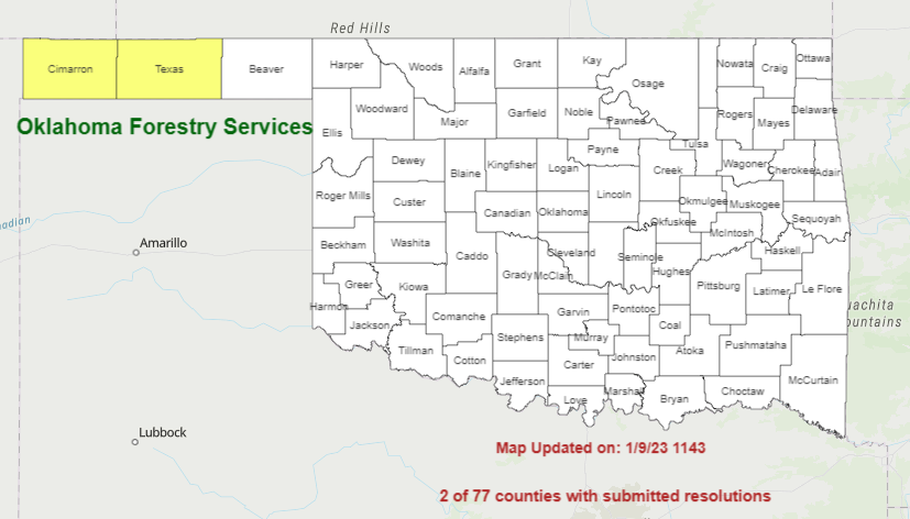
Burn Bans:
Refer to: https://okforestry.maps.arcgis.com/apps/webappviewer/index.html?id=b60723d1490d4d84a95cf2776d88998a&extent=-11344098.9167%2C3925553.7399%2C-10677568.03%2C4512590.1171%2C102100


