

To view the Oklahoma Drought Map, click here.
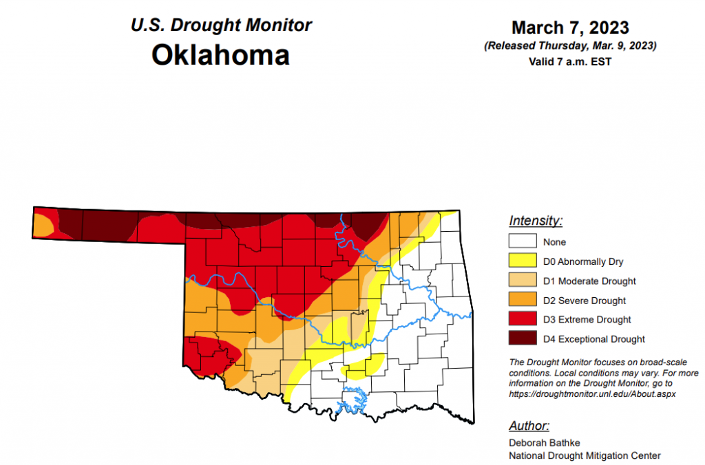
For the third week in a row, exceptional drought remains at 8.86 percent and extreme drought or worse remains at 36.64 percent. Rains this week will hopefully be reflected in next week’s report.
According to State Climatologist, Gary McManus, there is no guarantee that the current drought in northwest Oklahoma will end soon. However, there is hope for more rainfall, as the weather patterns are constantly changing and the region is prone to strong storms and heavy rainfall.
Severe drought or worse has improved only slightly, moving from 53.52 percent last week to 51.53 percent this week.
Moderate drought or worse has improved from last week’s 66.88 percent to 59.92 percent.
Abnormally dry or worse conditions have improved significantly this week, moving from last week’s 77.15 percent to 67.07 percent.
According to the 6-10-day precipitation outlook map, the majority of the state aside from the panhandle area is leaning above a 33 to 40 percent chance of precipitation through March 18th. The panhandle area is leaning above a 40 to 50 percent chance of precipitation through March 18th.
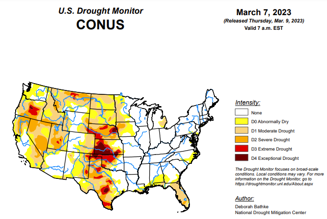
To view the United States Drought Monitor Report, click here.
According to the latest U.S. drought monitor report, a series of severe weather events moved across the South and Southeast this week, bringing damaging winds, tornados and heavy rainfall. As these storms moved through the Midwest, many locations experienced record daily rainfall. This same storm brought snow to the upper Great Lakes and parts of the Northeast. Precipitation was scarce across other areas of the country, including parts of the West, the High Plains and Deep South. Drought and dryness expanded in parts of the Pacific Northwest, southern Texas and the Gulf and Atlantic coasts. Drought improvements were seen across the West from prior weeks’ precipitation events. In addition, parts of the southern Plains, Great Lakes and mid-Northeast regions also saw improvements.
In the Southern Plains, storms brought high winds, tornadoes and heavy rain to parts of the South. A band of heavy rain, over 300 percent of normal (over the last 7 days), fell over drought areas in north-central and central Texas. But, because precipitation is low in Texas this time of year, totals ranged from about 0.5 to 1 inch and provided minimal relief to areas in moderate (D1), severe (D2) and extreme (D3) drought. Longer term deficits remain, and streamflow values quickly returned to below normal over much of the region. Otherwise, most of Texas received little to no rainfall, and many locations experienced an expansion of drought conditions. In the Panhandle, D3 expanded slightly. Precipitation there is less than 25 percent of normal over the last 30 days, and satellite derived soil moisture is very low (5th percentile or less). In South and West Texas, all drought levels expanded as the dry pattern continued. Precipitation in these areas has been less than 10 percent of normal over the last 30 days. The dry weather, combined with temperatures of 3 to 6 degrees above normal, has dried out soils and increased fire danger (as indicated by the Keetch Byram Drought Index). CoCoRaHS observers in South Texas note the lack of measurable rain, cracks in the soil and plants with discoloration and delayed growth. In Oklahoma, 5 to 10 inches of rain fell last week (300% of normal) over the state’s eastern drought boundary. Repeated bouts of moisture have led to short-term improvements overwhelming longer-term deficits, resulting in 1-category improvements. The state climatologist for Oklahoma noted that over half of the reservoirs in the southeast part of the state are now over their conservation pool or close to normal. Meanwhile, short- and long-term drought still have a grip on the northwest part of the state. Dry conditions combined with above normal temperatures and high winds have resulted in several fires.
In the High Plains, much of the High Plains remains in long-term drought, with the central High Plains seeing some expansion of moderate drought (D1) from southeast Nebraska to northeastern Kansas based on continued lack of recent precipitation, low streamflows and soil moisture. In the Colorado Rockies, abnormal dryness (D0) was slightly expanded based on below-normal precipitation. In south-central Colorado, abnormal dryness (D0) was expanded because of continued lack of precipitation and low soil moisture. However, southeast Kansas received heavy rain from severe storms that extended from the South and Southeast into the Great Lakes regions. The northern High Plains also saw improvements in north-central/northeastern Nebraska and southeastern North Dakota in response to the season’s heavy snows. Soils are still frozen, so the full benefits of the season’s precipitation will not be realized until the soils thaw and the snow meltwater soaks into the ground. Wyoming also saw improvements to moderate drought (D1) where precipitation deficits have recovered.
In the West, this week, additional rounds of rain and snow added to the ample precipitation received across the West since December 2022. Continued analysis of the effects of the season’s moisture resulted in continued improvements to long-term drought conditions in many parts in the West. California saw improvements to severe (D2) and moderate (D1) drought, as well as abnormal dryness (D0) along the central coast and in the San Joaquin Valley and southern California. National Weather Service offices in the area report extremely wet conditions. Water-year-to-date (WYTD) precipitation is 150% of normal or higher, and nearly every indicator shows improvement with all but the longest timescales (24-to-36-month precipitation) showing above-normal conditions. Similarly, the season’s precipitation chipped away at long-term drought areas in southern Nevada (D2 and D3), parts of Utah (D2 and D3) and western New Mexico (D1, D2 and D3). Precipitation deficits, soil moisture and streamflow show recovery. Groundwater levels and reservoir storage, which takes longer to recover, however, remain low. Precipitation in the Pacific Northwest helped improve severe drought (D1) in western Idaho and abnormal dryness (D0) in southwest Montana. Precipitation indicators in these areas are wet out to 12 months. In the rest of the Northwest, recent precipitation wasn’t enough to warrant improvement. Moderate drought (D1) expanded in north central and northeast Oregon where WYTD precipitation, streamflow and soil moisture is low. The Oregon state climatologist notes that “This water year has been surprisingly dry across the state despite the near-normal snowpack. Approximately 70% of the state only has 75% of normal WYTD precipitation, and about 25% is below 50% of average.” In Montana, severe drought (D2) expanded in response to low snow accumulations and its effect on streamflow and soil moisture.
Looking ahead, the National Weather Service Weather Prediction Center forecast for the remainder of the week (valid March 8 – March 11) calls for an atmospheric river to bring heavy rainfall, flooding and high-elevation snow to the West Coast. A winter storm tracking across the central High Plains and upper Midwest is also expected to bring snow to these regions, with the heaviest amounts in southern Minnesota, northern Iowa and southern Wisconsin. As this storm moves eastward, mixed precipitation is likely in a band stretching from eastern Nebraska to southern New York. Heavy rain and thunderstorms are expected across the southern Plains, the South, lower Midwest and the Southeast.
Moving into next week, the Climate Prediction Center’s 6-to-10-day outlook (March 13 – March 17) calls for above-normal temperatures across the Southwest with below-normal temperatures across much of the Lower 48 and Alaska. Most of the U.S. can expect near- to slightly above-normal precipitation. Parts of the Midwest and Northeast are the only areas with slightly increased odds for below-normal precipitation.


