

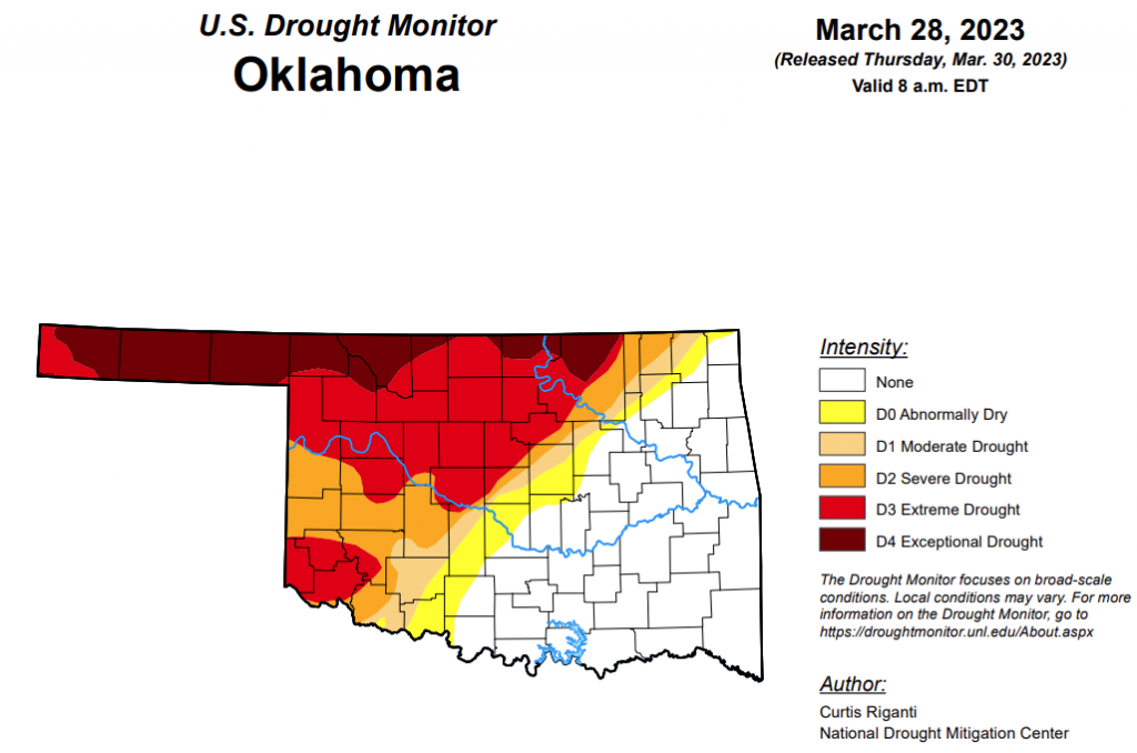
To view the Oklahoma Drought Map, click here.
According to the latest Oklahoma Drought Monitor report, Exceptional drought in the state has increased from 11.2 percent to 12.8 percent since last week.
Extreme drought or worse has increased slightly from 36.6 percent to 37.3 percent.
Severe drought or worse has decreased from 50.1 percent to 48.5 percent.
Moderate drought or worse has decreased from 59.07 percent to 53.6 percent.
Abnormally dry or worse conditions have also decreased from 65.6 percent to 60.3 percent.
According to the 6-10-day precipitation outlook map, roughly the southeast half of the state is leaning above a 40 to 50 percent chance of precipitation through April 8. Central Oklahoma and further west, including the panhandle and that southwest region is leaning above a 33 to 40 percent chance of precipitation through April 8.
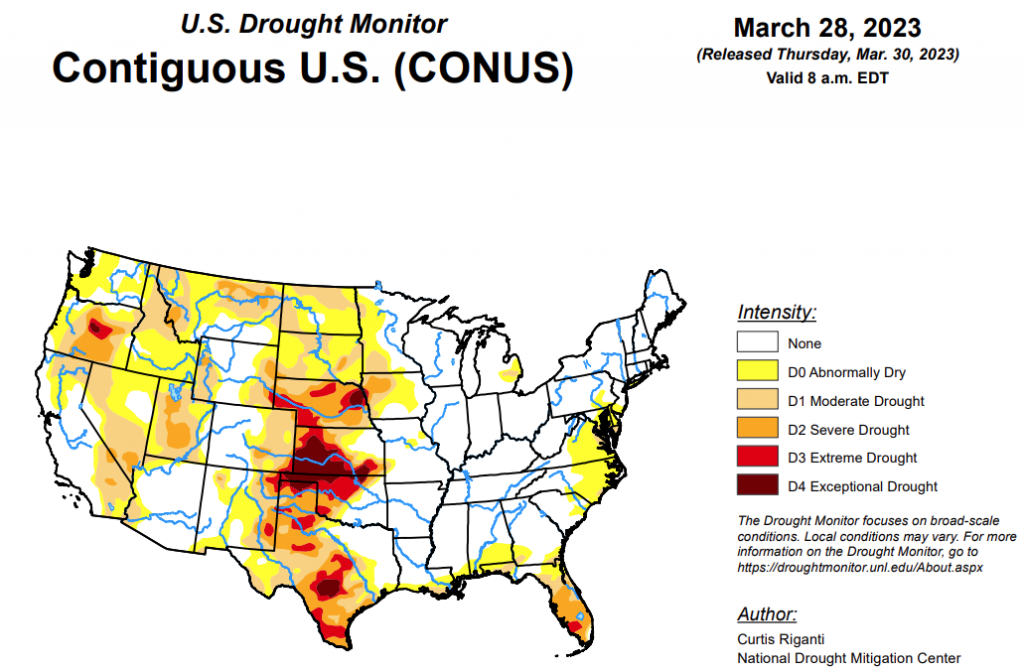
To view the United States Drought Monitor Report, click here.
According to the latest U.S. drought monitor report, after the wet pattern continued in parts of the West this week, building off of widespread wet and snowy weather this winter, widespread improvements were made to the drought depiction, especially in northern California, northern Nevada, southern Idaho and Utah, with scattered changes, mostly improvements, also taking place in other western states. East of the Rockies, drought and abnormally dry conditions mostly stayed the same or worsened in the Texas and Oklahoma panhandles, northwest Oklahoma, and central and southeast Texas. The western edge of heavy rains this week fell mostly along and southeast of the Interstate 44 corridor in Oklahoma and western north Texas, leading to further tightening of an already tight drought condition gradient in these areas. Farther west in northwest Oklahoma and western Kansas, extreme and exceptional drought persisted or intensified. Very dry recent weather continued in the Florida Peninsula, where severe drought expanded in coverage and extreme drought developed in response to quickly increasing fire danger. In the Mid-Atlantic, short- and long-term drought and abnormal dryness grew a bit in coverage this week. Conditions also worsened in northwest Puerto Rico and the southern Puerto Rico coast, the latter of which reported nearby forest fires. For more specific details, please refer to the regional paragraphs below.
In the Southern Plains, aside from Oklahoma and southwest Texas, near-normal or warmer-than-normal temperatures were common across much of the South region, with some locations seeing temperatures 5-10 degrees warmer than normal. Parts of north-central Texas and Oklahoma (especially southeast of Interstate 44) saw moderate to heavy rain amounts from thunderstorms, exceeding an inch or two in a few spots. Over 2 inches of rain fell across large areas of Arkansas and Tennessee, while heavier rains farther south in Louisiana and Mississippi were more scattered in nature. Some of this rainfall was associated with a severe thunderstorm outbreak, which was responsible for a destructive tornado that reached a maximum intensity of EF4 in Rolling Fork, Miss. Most of the rest of Texas, and Oklahoma northwest of Interstate 44, remained mostly or completely dry. The recent dry weather, very low groundwater and streamflow and mounting long-term precipitation deficits in central Texas and parts of the Edwards Plateau led to the expansion of moderate, severe, extreme and exceptional drought in some areas. Short-term dryness and decreasing streamflow also led to expanding drought conditions farther east in Texas, except for areas that saw heavier rain amounts this week. Short- and long-term extreme and exceptional drought also increased in coverage in the Texas Panhandle, the Oklahoma Panhandle and parts of northwest Oklahoma, the latter of which has recently experienced blowing dust and sand and a struggling winter wheat crop. Along the Interstate 44 corridor, the gradient in drought conditions increased further, with areas west of Oklahoma City experiencing extreme drought, while southern suburbs of Oklahoma City are only abnormally dry now, with dryness-free conditions nearby to the southeast.
In the High Plains, the region generally saw drier weather this week, with a few areas of the central and northern Great Plains seeing some precipitation. Heavier snows also occurred in some of the mountainous areas of Colorado and Wyoming, leading to some improvements to drought and abnormal dryness areas there. Colder-than-normal weather occurred over the entire region. Compared to normal, the coldest temperatures, in some cases 15 to 20 degrees below normal, occurred in North Dakota, western Wyoming and western Colorado. In southern Colorado, abnormal dryness and moderate drought lessened in coverage in the San Luis Valley and Sangre de Cristo Mountains. Recent precipitation and lessening long-term precipitation deficits, as well as deep snowpack in some areas, led to some localized improvements to ongoing drought areas in the Dakotas, western Nebraska and far northeast Colorado, while mounting precipitation deficits and low soil moisture led to localized worsening of conditions in eastern Nebraska and northeast North Dakota.
In the West, a wet pattern continued in parts of the West this week, especially western Oregon and Washington and coastal California and parts of the Sierra Nevada. Locally heavy precipitation amounts also fell in parts of Utah and central Arizona. Colder-than-normal temperatures also occurred over most of the West region this week. Temperatures generally ranged from 5 to 10 degrees below normal in the northern, western and southern parts of the region, while Nevada, Utah and southern Idaho experienced temperatures ranging from 10 to 20 degrees colder than normal. The recent snowfall in southern Colorado in the Sangre de Cristo Mountains also allowed for improvements to conditions across the border in New Mexico. Large areas of the Intermountain West saw improvements to drought conditions this week, as long-term precipitation deficits lessened, snowpack remained high or grew, soil moisture and streamflow increased or remained high and groundwater conditions improved. Extreme drought was removed from central Utah, while moderate and severe drought lessened in coverage there. Much of southern Idaho and northern Nevada saw improvements this week after hefty precipitation amounts this winter. Conditions also improved west of Las Vegas, where long-term precipitation deficits lessened and groundwater and soil moisture locally improved. Moderate drought was removed in parts of northern California as well, where long-term precipitation deficits continued to lessen. For similar reasoning, drought coverage lessened in a few parts of Montana as well. Due to recent precipitation and large snowpack and lessening long-term precipitation deficits, moderate drought and abnormal dryness lessened in coverage in western Oregon.
Looking ahead, from the morning of Wednesday, March 29 through the evening of Monday, April 3, the National Weather Service Weather Prediction Center is forecasting precipitation in some of the higher elevation areas of California, with heavier amounts likely in western Oregon and Washington. Some mountainous areas of Idaho, Colorado, southwest Montana, Wyoming and Utah will likely see over 0.75 inches of precipitation, with some locally heavy amounts possible. Farther east, the southern Great Plains are likely to remain dry, while precipitation is likely from South Dakota into the Upper Great Lakes, and from the Lower Great Lakes southwest toward the Lower Mississippi Valley as a strong storm system traverses the central Great Plains and Midwest. Localized precipitation amounts at or exceeding 0.75 inches are possible for northeast New York and Vermont as well.
From April 4-8, the National Weather Service Climate Prediction Center forecast strongly favors colder-than-normal weather in the West and warmer-than-normal conditions in the Southeast, with the dividing line between warmer and colder than normal running from Chicago southwest to St. Louis southwest to the Texas Big Bend region. Northwest of this line, below-normal temperatures generally become more likely, with the opposite true southeast of this line. Below-normal temperatures are slightly favored in much of Alaska, especially in the southeast regions. Above-normal precipitation is favored across much of the contiguous U.S., excluding the Florida Panhandle, western Montana, southern Arizona, New Mexico, and the El Paso area. The highest confidence for above-normal precipitation for this time period is over South Dakota, North Dakota and Minnesota. Wetter-than-normal weather is also favored in Alaska.
To view the 6-10 Day Precipitation Outlook Map, click here.
To view the 6-10 Day Temperature Outlook Map, click here.
To view the Monthly Drought Outlook Map, click here.


