

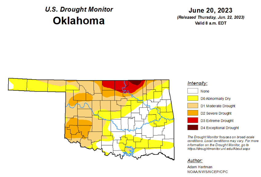
To view the Oklahoma Drought Map, click here.
According to the latest Oklahoma drought monitor, Exceptional drought has improved from last week’s 1.45 percent and is now at .52 percent.
Extreme drought or worse has improved from last week’s 5.85 percent and is now at 4.79 percent.
Severe drought or worse has improved significantly from last week, moving from 25.38 percent to 16.59 percent.
Moderate drought or worse improved from last week’s 49.25 percent to this week’s 41.91 percent.
Abnormally dry or worse conditions worsened, moving from last week’s 65.01 to this week’s 73.21.
According to the 6-10-day precipitation outlook map, the majority of the state is standing at a near-normal chance of precipitation through July 1. The southern border is leaning below a 33 to 40 percent chance through that date.
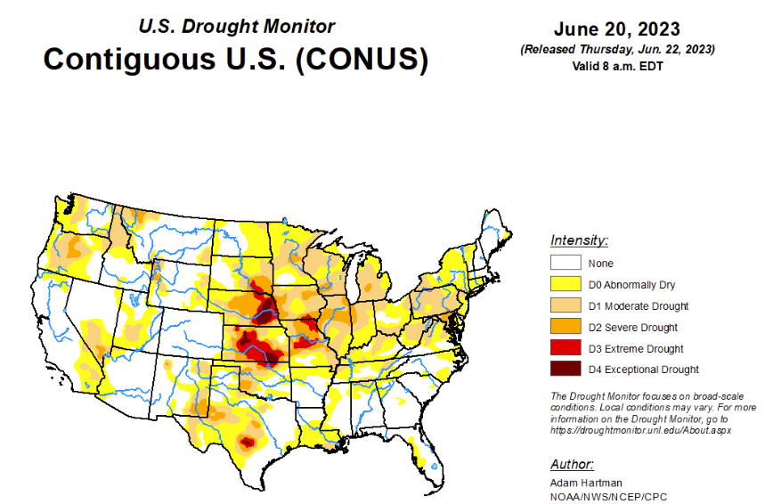
To view the United States Drought Map, click here.
According to the latest U.S. Drought Monitor report, much of the lower 48 states experienced near to below-normal temperatures this week, with the exception of parts of the northern Great Plains, Upper Midwest, southern Texas, and parts of the Lower Mississippi Valley. Large portions of southern Texas experienced excessive heat this week, with daytime high temperatures averaging well above 100°F for several locations. A mean frontal boundary draped across much of the lower 48 states resulted in periods of heavy rainfall across portions of the western Great Plains and Intermountain West, leading to improvements to drought conditions across much of the western half of the lower 48 states. The only exception was in the northern Cascades in Washington, where below-normal precipitation led to worsening drought conditions. Heavy rain also fell across parts of the Southeast, with many locations across the Deep South receiving in excess of 5 inches of rainfall, leading to improvements to abnormally dry and moderate drought conditions from central Mississippi southeastward to Florida. Toward the end of the weekend, a slow-moving storm system traversing eastward across the Middle Mississippi and Ohio Valleys resulted in additional periods of heavy rainfall across portions of the eastern U.S. However, much of the Mississippi and Ohio Valleys and the Northeast experienced a mix of worsening and improving drought conditions based on antecedent dryness and where the heaviest rain fell, respectively. Another round of deterioration was warranted again this week across much of the Midwest and eastern Great Plains, where below average precipitation continued to add to precipitation deficits that go back several months.
In the Southern Plains, several rounds of heavy rainfall associated with clusters of thunderstorms traversed portions of the Southern region from Oklahoma to Mississippi, leading to targeted improvements to abnormal dryness (D0) and drought conditions. Additional improvements to the drought depiction are also warranted across portions of the Texas Panhandle, where drought indicators have continued to improve due to well above average (in some cases record) rainfall over the past 60 days. Conversely, targeted degradations are warranted across parts of the Lower Mississippi and Tennessee Valleys, where short-term dryness continues to increase. Excessive heat, especially during the latter portions of the week, helped to exacerbate dryness across portions of southern Louisiana and coastal areas of eastern Texas, where 30-day rainfall deficits continue to increase.
In the High Plains, much of the Northern Plains received below average rainfall this week, adding to short-term precipitation deficits. In conjunction with the below average weekly rainfall, above normal temperatures and high winds (typical for this region) only acted to exacerbate worsening drought conditions by increasing evaporation from soils and vegetation. As a result, widespread degradation of abnormal dryness (D0) and drought was warranted this week across the Dakotas. Degradation was also warranted farther southward, extending across the eastern Great Plains all the way to Kansas, despite more seasonal daytime high temperatures this week. Conversely, across western portions of the High Plains region, another round of improvements is warranted, as yet another week of above normal rainfall (with many areas receiving upwards of 2 inches of rainfall, with locally higher amounts) was observed across many areas, leading to improvements to long-term drought conditions.
In the West, another week of above normal rainfall across many areas of the Intermountain West resulted in widespread, yet targeted improvements to long-term drought conditions, assisted by near and below normal average high temperatures for the week. The only area that experienced worsening drought conditions was across parts of the northern Cascades in Washington, where year-to-date precipitation deficits have continued to climb (in excess of 12 inch deficits), and this is following a predominantly below average 2022-2023 winter rainy season. Soil moisture, groundwater levels, and stream flows continue to decline.
Looking ahead, according to the Weather Prediction Center (WPC), over the next 6 days (June 22 – 27) above normal temperatures are forecast to dissipate and become more seasonal across the Great Lakes and Middle and Upper Mississippi Valley, and become confined to the south-central U.S. Parts of the Southern Plains could see record heat this week, as temperatures are likely to soar well above 100°F for many locations, with the potential for some locations to exceed 110°F. Much of the remainder of the lower 48 states is likely to experience seasonal to below normal temperatures. WPC predicts above normal precipitation across portions of the Central and Northern Plains and Upper Midwest, with the potential for several areas to receive in excess of 3 inches of rainfall. Above normal rainfall is also expected across much of the Eastern U.S., associated with a lingering storm system helping to usher in moisture from the western Atlantic.
During the next 6 to 10 days (June 27 – July 1), the Climate Prediction Center (CPC) favors near to below normal temperatures across much of California and the central Great Basin. Near to below normal temperatures are also predicted across much of the northern tier states from the Northern Plains to the Great Lakes, and southeastward into the Mid-Atlantic. Above normal temperatures are favored in the Pacific Northwest and New England. Above normal temperatures are strongly favored across the south-central U.S., with the potential for record heat across portions of the Southern Plains and Lower Mississippi Valley. Near and above normal precipitation is favored across much of the lower 48 states. However, below normal precipitation is more likely across the Four Corners region, extending eastward into the Southern Plains and Lower Mississippi Valley.
To view the 6-10 Day Precipitation Outlook Map, click here.
To view the 6-10 Day Temperature Outlook Map, click here.
To view the Monthly Drought Outlook Map, click here.


