

Another week of improvements in the Oklahoma drought monitor!
To view the Oklahoma Drought Map, click here.
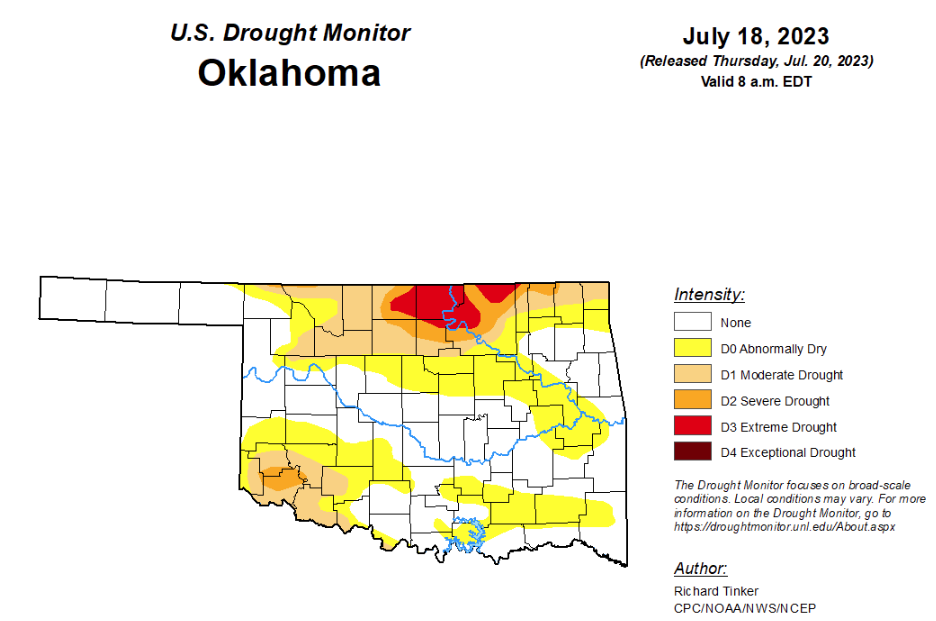
According to the latest Oklahoma drought monitor, exceptional drought is now at zero, down from last week’s .42 percent.
Extreme drought or worse has improved from last week’s 4.2 percent down to this week’s 3.23 percent.
Severe drought or worse has improved from last week’s 9.12 percent to this week’s 7.31 percent.
Moderate drought or worse has improved slightly as well, moving from last week’s 23.63 percent to this week’s 20.32 percent.
Abnormally dry or worse conditions have improved from last week’s 56.96 percent to this week’s 50.96 percent.
According to the 6-10-day precipitation outlook map, the entire state is leaning below a 33 to 40 percent chance of precipitation through July 29.
To view the United States Drought Map, click here.
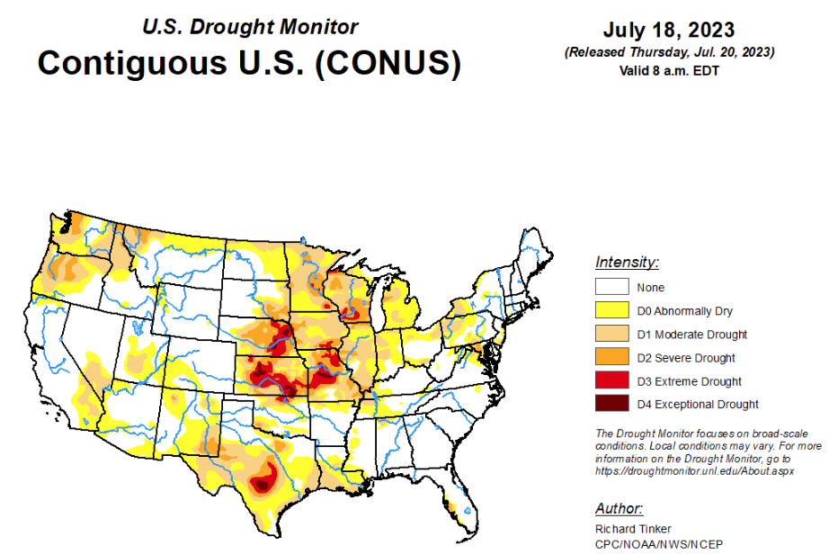
According to the latest U.S. drought monitor, Last week featured a highly variable precipitation pattern across the contiguous states. Over 3 inches of rain fell on broad areas across the central Appalachians, central and southern Virginia, parts of the northern and central Carolinas, much of New England and the adjacent Northeast, parts of Florida, the central Gulf Coast Region, the lower and middle Mississippi Valley, the Upper Midwest, the southern Great Lakes Region, and the central Great Plains. Between 5 and 7 inches soaked some areas in the southern tier of Arkansas, areas near the central Alabama/Mississippi border, the Florida Panhandle, and southwestern Virginia. In contrast, very little precipitation fell from the Rockies westward to the Pacific Coast,, the Dakotas, Oklahoma and western Kansas, most of Texas, central and western Louisiana, part of the Illinois Valley, the Tennessee Valley, the interior Southeast, parts of the upper Ohio Valley, most of the coastal and piedmont areas in the Carolinas, upstate New York, and the central mid-Atlantic Region. In the south-central and southwestern parts of the Lower 48, intense heat accompanied dry weather, with the week averaging 5 to 9 deg. F above normal from Texas westward through the desert Southwest and part of the southern half of the Rockies. Temperatures reached 129 deg. F near Baker, CA on July 16. Elsewhere, the Northeast, Florida, the lower Mississippi Valley, and the West Coast States were also warmer than normal.
In the Southern Plains, a broad range of conditions can be found across the region, and even regarding the week’s rainfall totals, some got too much while others languished in heat and drought. Most of Texas was dry this past week, and conditions deteriorated south of the Panhandle. D3 and D4 conditions (extreme to exceptional drought) expanded in the middle of the state, and severe drought (D2) pushed northward toward the central Red River Valley. Agriculture is increasingly impacted by the drought here, with 45 percent of the Texas cotton crop in poor or very poor condition. Almost half of rangelands were in poor or very poor condition, increasingly stressing livestock. In addition, 27 percent of Texas oats are in poor or very poor condition.
Elsewhere, the only other area remaining in D2 to D3 are north-central and southwestern Oklahoma, and agricultural impacts have been far milder outside the Lone Star State. Heavy rains over the past two weeks have left a large swath across the Panhandles, central Oklahoma, the north half of the Lower Mississippi Valley, and much of Tennessee free of any abnormal dryness.
In the High Plains, drought remained widespread across Kansas, Nebraska outside the Panhandle, and southeastern South Dakota, with some swaths of improvement incurred in eastern parts of Nebraska and Kansas. Meanwhile, dryness and drought expanded slightly across northern North Dakota, and with the Southwest Monsoon off to a slow start, abnormal dryness has developed over a large part of the southwest quarter of Colorado. Other parts of the central Rockies and most of the Dakotas are unchanged from this past week. In South Dakota, 31 percent of Spring Wheat and 19 percent of oats are in poor or very poor condition, along with 15 percent of Spring Wheat in North Dakota.
Looking ahead, according to the Weather Prediction Center (WPC), over the next 5 days (July 20 – 24, 2023) moderate to heavy precipitation is expected across parts of the central and southern High Plains from central New Mexico northward into southeast Wyoming, and eastward across western Kansas, the Oklahoma Panhandle, and adjacent locales. Totals near or over 2 inches are forecast for parts of northeastern Colorado, western Kansas, and the Oklahoma Panhandle. Light to locally moderate amounts are expected in higher elevations of the southern Rockies and some adjacent locations, with at least a few tenths of an inch possible over the central Rockies and part of the Great Basin. Little or no precipitation is expected elsewhere from the Plains States westward to the Pacific Coast, except in parts of extreme southeastern Texas. Most of the Lone Star State is forecast to receive little if any precipitation. Farther east, moderate to heavy rains are expected near the central Gulf Coast, southeaste4rn Georgia and the eastern Carolinas, eastern Tennessee, and parts of the northern Appalachians. Anywhere from 1.5 to locally 3.5 inches of precipitation may fall from extreme southeastern Louisiana across southern Alabama and the adjacent Florida Panhandle, The Coastal Plains in Georgia and South Carolina, northeastern North Carolina, and a few areas scattered across northern Pennsylvania, central and northeastern New York, and western New England. Light to moderate totals are expected over most of the middle and lower Mississippi Valley, the mid-Atlantic Region, the Great Lakes Region, and the Ohio Valley, and portions of Peninsular Florida. Temperatures are expected to remain considerably above normal from the Rockies to the Pacific Coast, over much of the northern and southern Plains, across Peninsular Florida, and in New England. Temperatures should average closer to normal elsewhere, with slightly cooler than normal conditions expected over and near the greater Ohio Valley and the adjacent interior Southeast.
During the ensuing 5 days (July 25 – 29), the Climate Prediction Center (CPC) favors above normal temperatures for almost all of the contiguous states and Alaska, except in the Pacific Northwest. Odds for significantly above-normal temperatures exceed 70 percent in a large area encompassing the eastern Great Basin, central and southern Rockies, and most of the Plains from central North Dakota southward into central Texas. Meanwhile, there are slightly enhanced odds for wetter-than-normal weather over the southeastern Great Lakes Region, the interior Northeast and New England, the western Great Lakes Region and upper Mississippi Valley, and western Washington. Odds slightly favor drier-than-normal weather in the northern Intermountain West, the Great Basin, much of Oregon and adjacent California, the southern High Plains, most of the central and southern Great Plains, the middle and lower Mississippi Valley, the lower Ohio Valley, the Tennessee Valley, the Southeast, and the South Atlantic Coastal Plain from northern Florida into North Carolina.
To view the 6-10 Day Precipitation Outlook Map, click here.
To view the 6-10 Day Temperature Outlook Map, click here.
To view the Monthly Drought Outlook Map, click here.


