

To view the latest Oklahoma drought map, CLICK HERE.
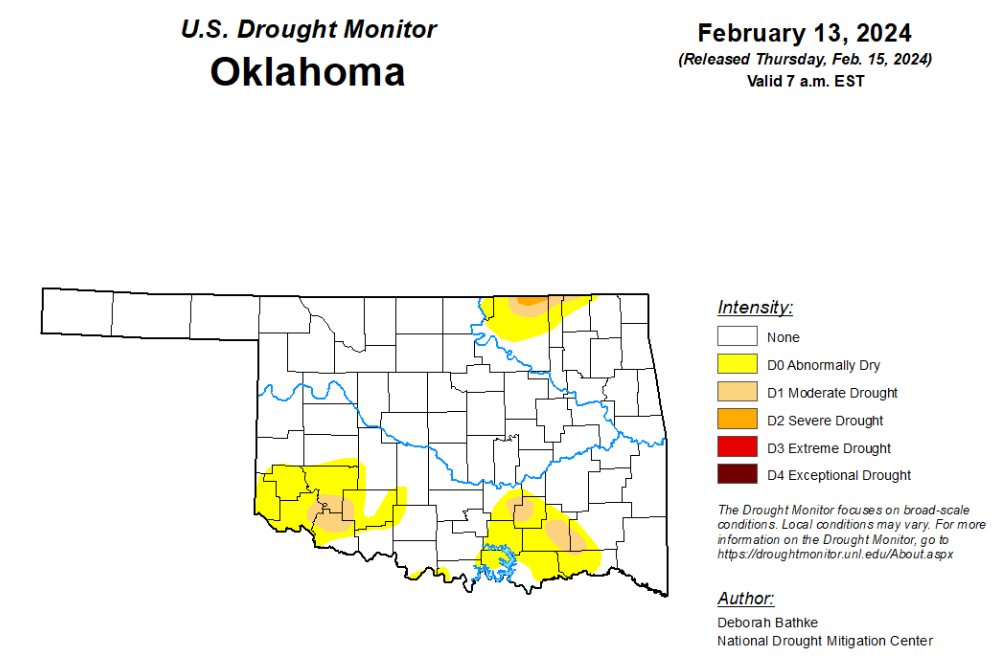
According to the latest Oklahoma drought monitor report, exceptional drought remains at zero percent, unchanged from the start of the calendar year.
Extreme drought or worse remains at zero percent, unchanged from the past seven weeks.
Severe drought or worse is now at .19 percent, down from last week’s 1.36 percent.
Moderate drought or worse is now at 3.23 percent, down from last week’s 7.18 percent.
Abnormally dry or worse conditions are now at 16.61 percent, down from last week’s 21.48 percent.
According to the 6-to-10-day precipitation outlook map, the panhandle and the northern border of Oklahoma are leaning below a 33 to 40 percent chance of precipitation through February 24th. The remaining part of the state is leaning below a 40 to 50 percent chance of precipitation through February 24th.

To view the United States Drought Map, click here.
According to the latest U.S. Drought Summary, last week, another round of Pacific storms swept across the West, bringing rain and mountain snow. Storms left over 3 feet of snow in the northern Arizona mountains before dropping more than a foot of snow in the mountains of Colorado and New Mexico. After a slow start to the year, basin snowpack in the Southwest has returned to near-normal conditions. Southwestern states saw improvements to short- and long-term drought conditions. In the Northwest, basin snowpack remains below normal with some of the worst conditions in the northern Rocky Mountains. The lack of snow led to the expansion of drought conditions. The wet pattern continued in the South and Southeast. In the last 30 days, rainfall totals of more than 10 inches (200 to 400 percent of normal) fell in parts of the South and Southeast.
The excess rain brought additional one- and two-category improvements to drought. The Northern Plains and Upper Midwest stayed relatively dry, with temperatures well above normal for the second week in a row. States in the Southern Plains saw pockets of improvements as long-term moisture deficits are finally showing signs of improvement. The winter storm that brought heavy snow to the Northeast on Wednesday occurred at the data cutoff for this week’s map.
In the Southern Plains, another round of wet weather brought 2 to 4 inches of rain to parts of Louisiana, Mississippi, and Tennessee. The continued wet weather left a band, stretching from east Texas to northeast Alabama, with rainfall totals of 6 to 12 inches — 200 to 400 percent of normal —over the last 30 days. Much of the region saw 1- and even 2-category improvements to drought conditions. All exceptional drought (D4) has been eliminated. Moderate (D1), severe (D2), and extreme (D3) drought remain in the region where drought signals can still be found in long-term indicators. Despite the record-breaking rainfall over the last several weeks, deficits of 4 to 10 inches over the last six months remain over parts of many parts of the region. Groundwater levels and deeper soil moisture also remain historically low for this time of year in some places. West Texas was the only area where drought expanded. Moderate drought (D1) was added in response to growing long-term moisture deficits and impacts to soil moisture, groundwater, and vegetation.
In the High Plains, high temperatures averaged about 8 to more than 20 degrees above normal. Precipitation of less than 0. 5 inches fell across much of the Dakotas, Nebraska, and Kansas. Southwest Nebraska, Kansas, and eastern Colorado saw 1-category improvements to long-term drought areas. Short-term moisture deficits have largely been eliminated. A dry signal remains in Nebraska and Kansas at timescales longer than about 6 months and moisture deficits linger in deeper soil levels and ground water. Moderate drought (D1) expanded in western South Dakota, near the Black Hills, and northeast Wyoming due to a lack of snow and below-normal soil moisture levels.
In the West, pacific storms swept across the West again this week, bringing rain and mountain snow. Over 3 feet of snow fell in the northern Arizona mountains. The mountains of Colorado and New Mexico saw over a foot in some locations. The recent storms brought some of the best snowfall totals to date for this year’s snow season. Basin snowpack in the Southwest has returned to near-normal conditions, prompting improvements to areas of moderate (D1), severe (D2), extreme (D3), and exceptional (D4) drought. The largest improvements occurred in New Mexico and southwest Colorado. In the Northwest, basin snowpack remains below normal with some of the worst conditions in the northern Rocky Mountains. This lack of snow led to the expansion of D1 across southern Montana, northern Wyoming, central Idaho, and south-central Oregon. D2 expanded in eastern Idaho and western Montana. D1 improved in southern Washington and northern Oregon where above-normal precipitation over the last six months has helped reduce long-term moisture deficits.
Looking ahead, the National Weather Service Weather Prediction Center forecast (valid February 15 – 17, 2024) calls for another round of rainfall to push into the West Coast, bringing heavy rain and high elevation snow to the Cascades, Sierra Nevada, and the Northern Rockies. Polar air from Canada is expected to bring cold, dry air into the Northern Plains. Snow is expected across the Central Plains and Ohio Valley. Heading into the weekend, the extended forecast (valid February 17 – 21, 2024) calls for increased chances of multiple atmospheric river events for parts of central and southern California. Areas of lighter precipitation may spread across other parts of the west. The Upper Midwest and Northeast may see some snowfall. Storms tracking across the Gulf of Mexico may bring rain to Florida. The Climate Prediction Center’s 6-to-10-day outlook (valid February 20 – 24, 2024) calls for an increased probability of above-normal temperatures across most of the continental U.S. (CONUS) and Alaska. Temperatures across southern California, the East Coast, and northern Alaska are expected to be near to below normal. Increased precipitation is expected across California, the interior West, southern Alaska, and the Northeast. Much of the remaining CONUS, northern Alaska, and the Big Island of Hawaii are expected to have below- or near-normal precipitation.
To view the 6-10 Day Precipitation Outlook Map, click here.
To view the 6-10 Day Temperature Outlook Map, click here.
To view the Monthly Drought Outlook Map, click here.


