

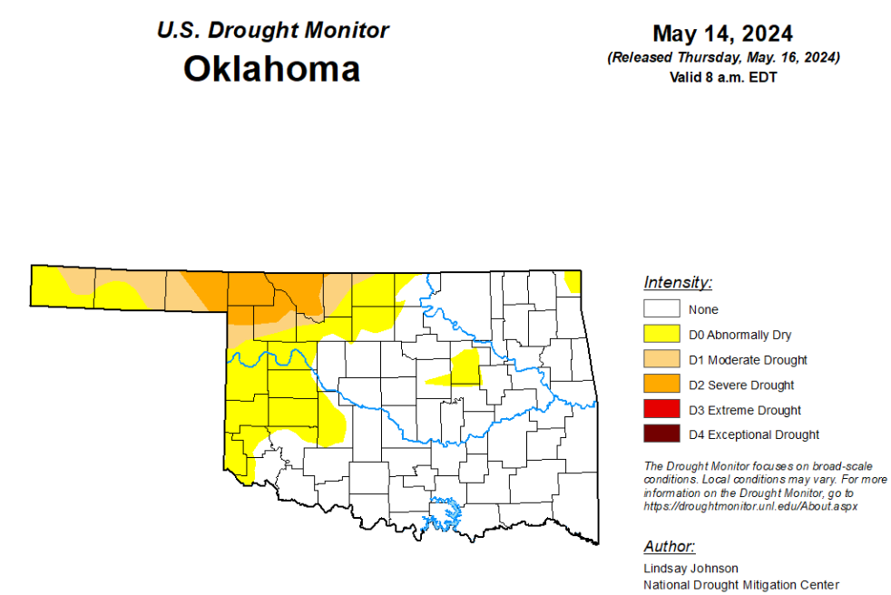
To view the latest Oklahoma drought map, CLICK HERE.
According to the latest Oklahoma drought monitor report, exceptional drought and extreme drought remain at zero percent, unchanged from the start of the calendar year.
Severe drought or worse is unchanged from last week at 5.91 percent.
Moderate drought or worse has improved from last week’s 20.41 percent and is now at 12.13 percent.
Abnormally dry or worse conditions are now at 32.64 percent, improved from last week’s 48.38 percent.
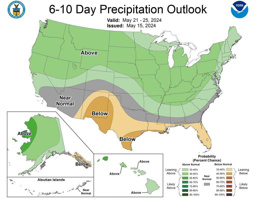
According to the 6-to-10-day precipitation outlook map, the west corner of the Oklahoma panhandle is leaning below a 33 to 40 percent chance of precipitation through May 25. The remaining parts of the panhandle, including western Oklahoma and the central part of the state can expect a “near normal” chance of precipitation through May 25th. The remaining eastern part of the state is leaning above a 33 to 40 percent chance of precipitation through that May 25th date.
To view the United States Drought Map, click here.
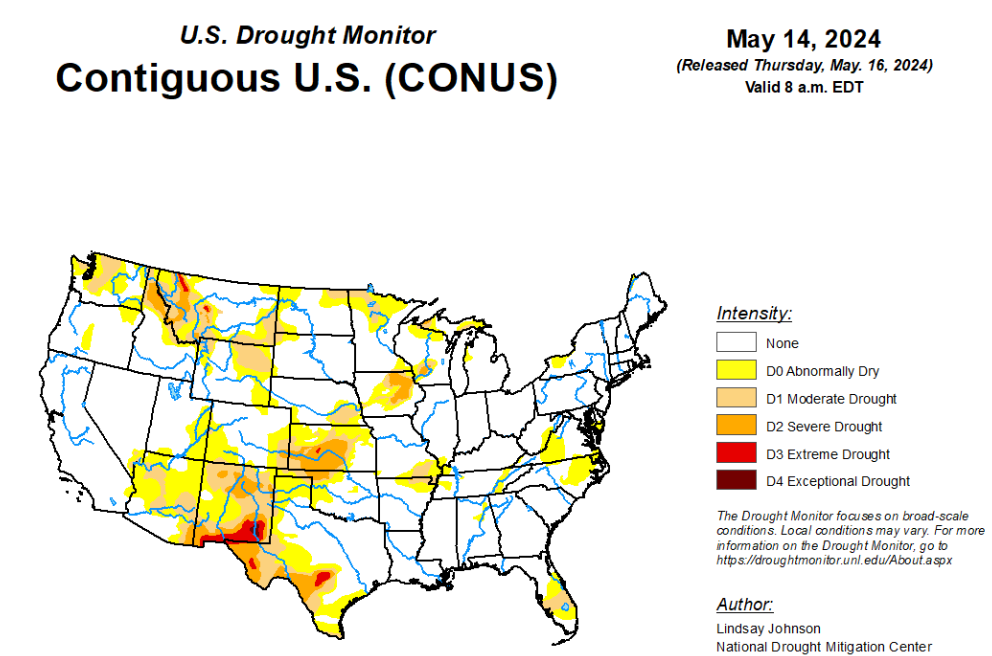
According the latest U.S. Drought Monitor, heavy precipitation fell across the Rocky Mountains of Montana, Wyoming and Colorado, as well as a large part of the South and southern Midwest. This brought widespread improvements to much of the South and Midwest, with scattered or widespread improvements in the Great Plains and Midwest. Heavy precipitation falling over the Southeast brought improvements from central Alabama into the southern Appalachian Mountains, as well as the area surrounding the convergence of the Ohio, Mississippi, and Tennessee rivers. A small area of the Mid-Atlantic region missed out on much of the precipitation, leading to minor degradations. Very dry weather for the past few months led to increased fire danger in parts of the Florida Peninsula, and short-term moderate drought and abnormal dryness expanded in coverage. Texas saw isolated degradations in the panhandle and south – where record breaking temperatures converged with the lack of precipitation. The High Plains were a mixture of light to moderate precipitation, which greatly influenced where improvements or degradations were made. Kansas, Colorado and Wyoming saw improvements where measurable precipitation fell. Degradations occurred in western Kansas and eastern Wyoming, where trace amounts of precipitation fell. Montana saw heavy precipitation, which improved conditions across much of the state. Isolated storms in western Oregon and Washington brought widespread improvements in Oregon, which continued into southwestern Washington. Central Washington, meanwhile, missed out on the precipitation and saw further expansion of abnormal dryness.
In the Southern Plains, the South saw a mixture of improvements in the north and degradation in the western and southern parts of the region. Western Texas, central Arkansas and northern Mississippi saw trace amounts of precipitation, while central and eastern Texas, Louisiana, and central and southern Mississippi saw between 2 to 5 inches of precipitation. Precipitation helped alleviate conditions in northern, western and southern Oklahoma. Following the precipitation, further improvements occurred across northern Arkansas and western and eastern Tennessee.
The Texas panhandle and southern parts of Texas saw expansion of existing abnormal dryness – and a small sliver of moderate drought (D1) in far south Texas – with a lack of measurable precipitation and above-normal temperatures. Southern Texas saw temperatures of 6 to 8 degrees above normal with Brownsville (124°F), Harlingen (125°F), and McAllen (122°F) breaking May temperature records of 115°F (5/4/1999), 121°F (5/26/1973), and 119°F (5/13/1995) respectively. A small area around the Missouri Bootheel also saw moderate drought (D1) expansion.
In the High Plains, there was a mixed bag of light to moderate precipitation, as well as improvements and degradations. Wyoming and Colorado saw improvements and degradations closely aligning with areas of moderate and light precipitation respectively. Northern and central Wyoming saw improvements, which were a continuation of improvements made in Montana and South Dakota. However, degradations occurred in areas that received trace amounts of precipitation along the eastern and southeastern part of these states into northern Colorado. Northeastern Colorado also saw a slight introduction of abnormally dry (D0) conditions as overflow from adjoining area of western Nebraska, where precipitation was low. Slight improvements occurred in south and northeast areas of Kansas that received precipitation. Elsewhere, conditions in central and western Kansas continued to degrade as streamflows, soil moisture, and groundwater continued to deteriorate. Southeast Nebraska saw slight improvements from continuous moisture over the past few weeks.
In the West, temperatures across the northern and Pacific coast of the West saw temperatures of 2 to 6 degrees above normal. Areas in northern California, northwest Oregon, south and central Washington and northeastern Montana experienced temperatures 6 to 8 degrees above normal. Little to no measurable precipitation fell over much of the West, except for Montana where 1 to 3 inches of precipitation fell. Conditions improved through most of central and western Montana with slivers of improvement in the parts where the short-term dryness from the weeks past have shown improvement. There were some isolated areas in western and southern Montana that saw degradations. Oregon saw widespread improvements in part due to the isolated precipitation and improved streamflow and soil moisture. These conditions were also seen in southern Washington where improvements were made. Central Washington, however, missed out on any meaningful precipitation and saw temperatures of 4 to 8 degrees above normal, leading to abnormal dryness (D0) expansion.
Looking ahead, over the next five days (May 16-21), heavy precipitation of2 to 5 inches is expected to continue to fall in the far South from central Texas to western Georgia, with 1 to 2 inches of rain expected in surrounding areas into the southern Midwest and Mid-Atlantic coast. The rest of the central and eastern United States will see some light precipitation. Much of the West will miss out on this precipitation.
The National Weather Service Climate Prediction Center’s 6-10 day outlook heavily favors above-normal temperatures from New Mexico to Wisconsin, Maine, and down into Florida, with the greatest possibility being in southern Texas. The Southwest and High Plains are expected to be near normal temperature and everything to the west is likely going to be cooler than normal. Hawaii and northern Alaska are likely going to be warmer than normal, whereas parts central and western Alaska are leaning towards below-normal temperatures. For precipitation, much of the country is leaning towards above-normal precipitation. New Mexico and central and southern Texas are leaning toward below-normal precipitation, with the western and eastern coasts likely to be around normal. The Big Island of Hawaii is likely to see above-normal precipitation, along with central and northern Alaska. Southern Alaska is leaning toward below-normal precipitation.
To view the 6-10 Day Precipitation Outlook Map, click here.
To view the 6-10 Day Temperature Outlook Map, click here.
To view the Monthly Drought Outlook Map, click here.


