

To view the latest Oklahoma drought map, CLICK HERE.
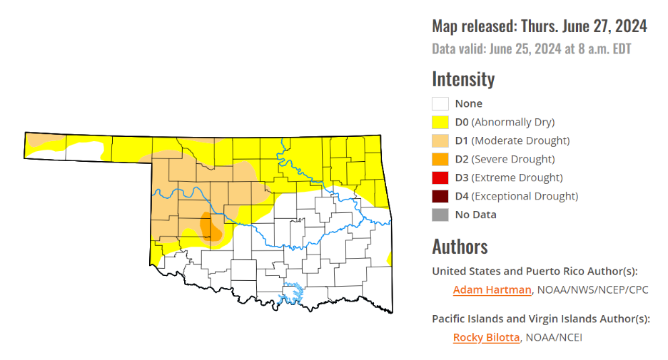
According to the latest Oklahoma drought monitor report, exceptional drought and extreme drought remain at zero percent, unchanged from the start of the calendar year.
Severe drought or worse is still at 3.78 percent, unchanged from last week.
Moderate drought, or worse, is now at 22 percent, which increased from 17.79 percent last week.
Abnormally dry or worse conditions are now at 69.21, up from last week’s 62.72 percent.
According to the 6-to-10-day precipitation outlook map, all of the state is leaning above normal chances of precipitation through August 10th. The western half of the panhandle is leaning above a 40 to 50% chance of precipitation through August 10th, while the rest of the state is leaning above a 33 – 40% percent chance of precipitation.
To view the United States Drought Map, CLICK HERE.
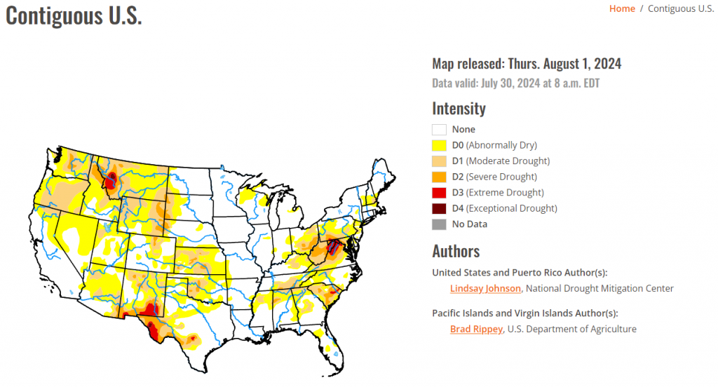
According to the latest U.S. Drought Monitor, heat continued to be the dominating feature in the Southwest and Plains. Temperatures were 2 to 6 degrees above normal, with isolated areas of 6 to 8 degrees above normal. The Southwest reached near record temperatures once again, with the highest 1-day maximum temperature for the week reaching 120 degrees in Death Valley and 110 degrees in surrounding areas. The West and Plains missed out on much of the precipitation that fell this week. These hot and dry conditions have lent themselves to increased fire potential and wildfires. The southern Plains missed out on the precipitation and experienced above-normal temperatures, leading to more drying and degradation. Similar degradations occurred along the western border of the High Plains due to the lack of precipitation, poor soil moisture, and declining streamflows. The Southeast, however, received substantial precipitation, vastly improving lingering dryness in the area. The northern Appalachian region saw 1-category degradations where streamflows in north-central West Virginia are critically low.
In the Southern Plains, Eastern portions of the South saw much of the heavy precipitation seen in the Southeast. Southeastern Texas into western Louisiana recorded areas of over 8 inches of rain falling this week. There was a sharp line of where the precipitation fell and did not. West of south-central Texas, northeastward to central Arkansas saw trace amounts of rain. Temperatures were also between 1 and 4 degrees below normal, with eastern Texas and western Louisiana having temperatures of 6 to 8 degrees below normal. Except for north-central Texas and parts of Oklahoma, and western Arkansas, 1-categoy improvements were made. Oklahoma saw a mixture of above- and below-normal temperatures, with hot temperatures heating up at the end of the week (July 23 to 30). Reports of “cover crops being cooked” and “no soil moisture for native grasses to draw from and large pastures have lost much green color and have shrunk considerably” in central Oklahoma’s Logan County.
The High Plains received trace amounts of precipitation, leading to already dry conditions in the western and southern High Plains to further deteriorate. Poor soil moisture in much of Kansas brought about widespread 1-category degradations. In eastern Kansas, along the Missouri border there have been reports dryness and heat stress. Central Kansas has also seen reports of dry ponds and fear of total crop failures. Some of these drier conditions spilled northward into southern Nebraska, which also saw areas of the northeast and western Panhandle deteriorate because of an extended period of dry conditions, dry vegetation, and low streamflow values. Similar conditions were seen across western South and North Dakota and Wyoming. Colorado saw deterioration in the northern Front Range, where extreme temperatures and low humidity made for perfect conditions for wildfires. Two fires were reported on Monday July 29: the Alexander Mountain Fire west of Loveland, the Stone Mountain Fire southeast of Estes Park.
In the West, the Northwest saw some relief from the extreme heat this week, with temperatures in Nevada, California, Oregon, and Washington being 2 to 6 degrees below normal. Conversely, the Southwest saw more extreme heat. Southern California, the southern tip of Nevada, and western Arizona saw temperatures of over 90 degrees this week with the highest 1-day maximum temperature reaching over 110 degrees. In the northern West, Montana saw slight improvements in the far north where temperatures were slightly below normal but saw similar conditions as North and South Dakota conditions in the central and eastern parts of the state. Central Utah saw minor expansion of abnormal dryness as streamflow began to drop and vegetation is looking dry.
Looking ahead, over the next five days (August 1-6), the Midwest, Northeast, and eastern Southeast are expected to see 1 to 2 inches of rain with heavier amounts predicted in the eastern Midwest and southern Florida. The rest of the Southeast will see more modest amounts of precipitation, deviating from their previous weeks of heavy precipitation. There is currently an Atlantic Disturbance that the National Hurricane Center show a greater than 60 percent chance of developing into a tropical cyclone within the next two days (August 1-2) which could bring heavy rainfall along the Atlantic Coast in the coming week. Isolated areas from Wisconsin, Minnesota, and Iowa to Kansas and higher elevations of Colorado, New Mexico, and Arizona are expected to receive around 1 inch of precipitation. Otherwise, precipitation will be light and spotty leading to much of the West, Texas, southern Oklahoma and Arkansas missing out on the precipitation.
The National Weather Service Climate Prediction Center’s 6-10 day outlook heavily favors above-normal temperatures from the Pacific Northwest across to the Southeast with conditions becoming near normal across the central U.S. and leaning to below normal temperatures further north toward Canada. Much of Alaska is expected to be above normal with below-normal temperatures possible to the southwest. Similarly, Hawaii is leaning towards above-normal temperatures. Many of the lower 48 states are leaning towards above-normal precipitation, centering around Wyoming and Colorado, along with the Atlantic Coast, which could see remnants of the Tropical Disturbance currently in the Caribbean. Alaska’s border with Canada is seeing up to a 70 percent chance of below normal precipitation, with the probability increasing in the west and southwest. Hawaii probability of seeing below-normal precipitation is 33 to 40 percent.
To view the 6-10 Day Precipitation Outlook Map, click here.
To view the 6-10 Day Temperature Outlook Map, click here.
To view the Monthly Drought Outlook Map, click here.


