

To view the latest Oklahoma drought map, CLICK HERE.
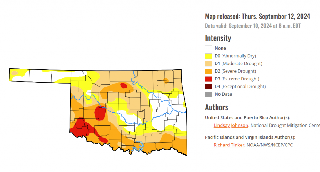
According to the latest Oklahoma drought monitor report, exceptional drought remains at zero percent, unchanged from the start of the calendar year.
Extreme drought has increased to 5.62 percent, up from 5.31 percent last week.
Severe drought or worse has increased to 28.63 percent, up from 18.44 percent last week.
Moderate drought, or worse, has increased to 60.63 percent, up from 48.22 percent last week.
Abnormally dry or worse has increased to 78.58, up from last week’s 74.36 percent.
According to the 6-to-10-day precipitation outlook map, most of Oklahoma is likely below a 40-50 percent chance of precipitation through September 17-21st. The western half of the panhandle and parts of the Southeast 40-50 percent chance of precipitation.

According to the latest U.S. Drought Monitor, There was a sharp difference in temperatures across the U.S. this week (Sep. 3 to Sep. 10). Temperatures in the West were above normal. In contrast, areas from Texas to Wisconsin and east saw temperatures of 3 to 9 degrees below normal. Very little precipitation fell, with Hurricane Francine providing most of it along the Gulf Coast. Overall, the central and eastern portions of the country saw continued deterioration, adding to already expansive decline from last week. The Ohio River Basin continues to be the epicenter of extremely dry conditions, though moderate and severe drought conditions are spreading through the southern Midwest into the Southeast. Improvements along the Gulf Coast were primarily due to the well-above-normal precipitation brought by Hurricane Francine. There were some other areas of improvement in New Mexico, northeastern Arizona, eastern Utah, southern Wyoming and northwestern Montana. Areas of the West that have not seen any meaningful precipitation in a while are beginning to see dropping streamflows and drying soils.
In the Southern Plains, The western portion of the South saw widespread improvements from central Texas to central Mississippi. Heavy rainfall from Hurricane Francine dropped 2 to 6 inches of rain, and the southeastern tip of Louisiana got as much as 14 inches of rain. Outside of the Gulf Coast, precipitation was lacking with precipitation hovering below normal. Temperatures were 2 to 6 degrees below normal, with localized areas being 6 to 8 degrees below normal. Central and southern Texas continued to see one-category improvements. Louisiana removed most of the abnormal dryness added last week due to abundant precipitation. Things started to degrade in Oklahoma, northeast Texas, Arkansas and northern Mississippi, where one-category degradations were widespread.
In The High Plains, The High Plains saw a mixed bag of improvements and degradations. The area remained hot and dry, except for eastern Nebraska and Kansas. Higher elevations of Colorado and Wyoming did receive some precipitation, but conditions remained mostly status quo. Kansas has experienced feast or famine precipitation since the beginning of summer. Some isolated, slow-moving thunderstorms provided good moisture in the center of the state, but abnormally dry or moderate drought conditions expanded along the Kansas western, southern and eastern borders. Eastern Colorado is beginning to show signs of a prolonged dry period, with moderate drought creeping further eastward from the Kansas border. Similarly, central and northern Wyoming are showing drier signals in the short-term, including soil moistures. These same conditions brought abnormally dry conditions along the North and South Dakota border and into southern and eastern Nebraska.
The Midwest continued to observe dry conditions this week, with the only improvements found in eastern Ohio and Michigan’s Upper Peninsula, where some precipitation fell. Despite the much-needed reprieve in heat, with temperatures being 2 to 6 degrees below normal for most areas, numerous cities had one of their hottest summers on record and abnormal dryness saw vast expansion. Many areas of the Midwest are now in abnormally dry or worse conditions. Kentucky, eastern Missouri, southern Illinois, southern and eastern Indiana and western Ohio all saw one-category expansions, especially moderate drought. Soil moistures in the southern and eastern Midwest are beginning to show signs of deeper level drying, with no precipitation to provide relief. Despite Ohio seeing improvement along the Ohio river, exceptional drought shifted centrally.
The West remained mostly dry with little to no precipitation and above-normal temperatures, except for southern New Mexico, where conditions improved mainly on the residual effects of a wet few weeks and are aided by below-normal temperatures. Central and northeastern Arizona and southeastern Utah also saw some improvements. Arizona also saw the expansion of moderate drought, overflowing into southern California. Central California also saw abnormally dry conditions expand. Northern Nevada, eastern Oregon, and west-central Idaho saw widespread moderate drought expansion due to warm temperatures, lack of precipitation, and drying soils. Washington into northwestern Idaho saw severe conditions expand, but extreme dryness was removed in Grant County, Washington as conditions were similar to the surrounding severe drought conditions.
Looking Ahead
Over the next five days (September 11-16), precipitation is expected in the high elevation of Alberta Canada into Montana and Idaho, southern Arizona, and across the Gulf and southern Atlantic Coasts. Precipitation amounts of 2 to 5 inches are expected in Mississippi, northern Alabama, western Tennessee, the Florida Panhandle, and coasts of North and South Carolina.
The National Weather Service Climate Prediction Center’s 6-10 day outlook heavily favors above-normal temperatures from the north-central to eastern Canadian border to the Texas-Mexican border, with Minnesota, Wisconsin, and Michigan 80 to 95% likely to see above-normal temperatures. Conversely, southern California and Arizona are 70 to 90% likely to see below-normal temperatures. Shifting northward towards the western Canadian border, there is a change of at- or slightly below-normal temperatures. Hawaii and northern Alaska are leaning toward above-normal temperatures.
The National Weather Service Climate Prediction Center’s 6-10 day outlook heavily favors above-normal precipitation in Montana, central Idaho, and the Atlantic Coast of Maryland, Virginia, and North Carolina. Alaska and Hawaii are also leaning toward above-normal precipitation. Arizona, New Mexico, the Gulf Coast of Texas and Louisiana, and the Great Lakes region are leaning towards below-normal rainfall.
To view the 6-10 Day Precipitation Outlook Map, click here.
To view the 6-10 Day Temperature Outlook Map, click here.
To view the Monthly Drought Outlook Map, click here.


