

To view the latest Oklahoma drought map, CLICK HERE.
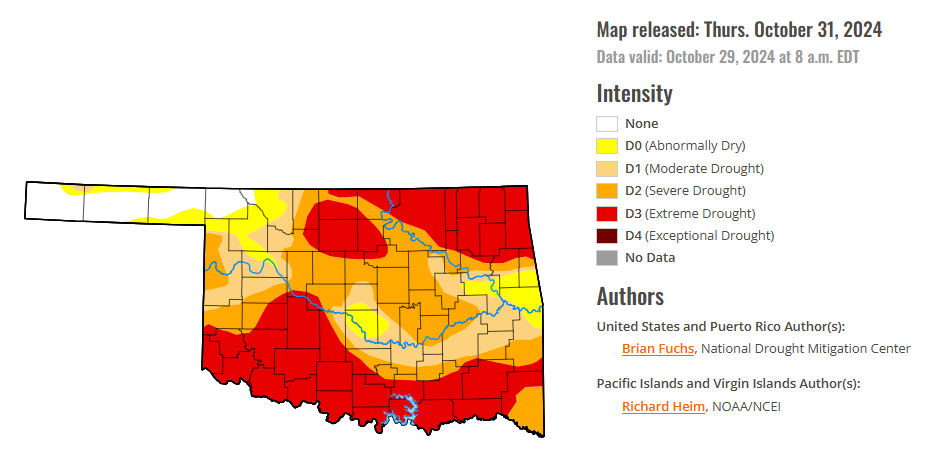
According to the latest Oklahoma drought monitor report, exceptional drought remains at zero percent, unchanged from the start of the calendar year.
Extreme drought or worse conditions have increased to 41.57 percent, up from 33.74 percent last week.
Severe drought or worse conditions have increased to 67.70 percent, up from 58.66 percent last week.
Moderate drought or worse conditions have increased to 83.54 percent, up from 78.62 percent last week.
Abnormally dry or worse conditions increased to 92.27 percent, up from 89.83 percent last week.
According to the 6-to-10-day precipitation outlook map, nearly the entire state of Oklahoma is leaning above a 40-50 percent chance of precipitation through November 9, 2024. Only the extreme tip of the panhandle is leaning above a 50-60 percent chance of precipitation through that November 9 date.

To view the United States Drought Map, CLICK HERE.
According to the latest U.S. Drought Monitor, the dry pattern that has been impacting much of the country has continued into this current period. The wettest areas were along the coast in the Pacific Northwest, with some locations recording over 2 inches of rain for the week. Other areas receiving some precipitation were in the Four Corners region, the Midwest and parts of the South, but many of these totals were minimal and did little to impact the drought conditions. The Southern Plains and South were the warmest regions, with departures of 10-12 degrees above normal this week. Almost the entire country was warmer than normal, with only areas of the Northeast and Pacific Northwest having near to slightly below normal temperatures. As the month is ending, many locations will be at or near record dryness across the country. For the Lower 48 states, there has not been this much drought shown on the U.S. Drought Monitor since December 2022. Areas of the Southeast that were impacted by significant precipitation associated with landfalling hurricanes have dried out rapidly, with some locations recording zero precipitation since the hurricanes. Some precipitation development at the end of the current period could help ease conditions into the next week, but that will be determined on the next map.
In the Southern Plains, temperatures were well above normal over the region with areas of north Texas and much of eastern Oklahoma 12-16 degrees above normal for the week. Some very light rains were reported in central Arkansas, but much of the region was dry this week. With the fall warmth and dryness impacting the region, drought intensified and expanded. In Oklahoma, the north-central and eastern portions of the state saw severe and extreme drought expand, with some moderate drought expanding in the east. Widespread degradation took place over much of northern and eastern Texas and into the southern portions of the state, where almost every drought category intensified, most now in severe drought or worse. Moderate and severe drought expanded over portions of West Texas as well. In Arkansas, most of the western portions of the state had degradation this week, now in severe to extreme drought. Moderate drought expanded over southeast Arkansas. Severe drought emerged in northwest and southwest Louisiana, and moderate drought expanded over more of the east and southeastern areas. In Mississippi, moderate and severe drought expanded in the southern half of the state and in a small area of the northeast part of the state. In Tennessee, the short-term dryness allowed slight expansion of the severe and moderate drought in the southern portions of the state. Abnormally dry conditions filled in the rest of northern Tennessee.
In The High Plains, dryness again dominated the region with only areas of far southeast Nebraska and northeast Kansas, northeast Wyoming and northwest South Dakota recording any significant precipitation. Coupled with the dryness, temperatures have been unseasonably warm for the region with most all areas 4-8 degrees above normal for the week. Drought expanded and intensified across the region this week with severe and extreme drought expanding over western North Dakota, and moderate drought and abnormally dry conditions expanding over the southeast. Severe and extreme drought expanded over much of western and southern South Dakota and also over western and northern Nebraska. Eastern Nebraska saw both moderate and severe drought expand. In Kansas, severe and extreme drought expanded over the southeast while severe drought expanded over the northeast and western portions of the state. Moderate drought also expanded in western Kansas. In northeast Colorado, moderate drought and abnormally dry conditions expanded, with both moderate and severe drought expanding in southeast Colorado. Southeast Wyoming saw expansion of moderate, severe, and extreme drought while eastern Montana had severe and extreme drought expand to the west.
The West was the one region that had substantial precipitation during the week, with rains in the areas of central to northeast Arizona, western Colorado, central to western Wyoming, central Utah, southern Oregon into Idaho and along the coastal areas of the Pacific Northwest. Minimal improvements were made to the abnormally dry conditions along the Oregon coast. Moderate drought improved in northern California and northern Nevada as well as into southern Oregon and Idaho. Abnormally dry conditions disappeared from the rest of southwest Colorado. Severe and extreme drought expanded in northern Colorado into southern Wyoming and severe drought expanded in western Wyoming.
Looking ahead, over the next 5-7 days, it is anticipated that the dry pattern will break over much of the Plains, Midwest and into the South, with widespread precipitation from north Texas to Wisconsin. The Western portions of the country will also be in a more active pattern, with the coastal areas, the Great Basin, and part of the Rocky Mountains seeing some precipitation. Temperatures will continue to be warmer than normal out in front of the precipitation, with the eastern Midwest, South, and East all anticipated to be warmer than normal, including departures of 13-15 degrees above normal in the Ohio River basin. Cooler- than-normal temperatures will settle in over the West, with departures of 10-13 degrees below normal over much of Nevada.
The 6-10 day outlooks show that the best chance for above-normal temperatures is over the East while much of the West has the best chance for below-normal temperatures centered on the Southwest. The greatest chance for above-normal precipitation is over the southern Rocky Mountains with above normal chances in the Plains and into the Midwest while the greatest chance for below-normal precipitation is over northern California and much of the West.
To view the 6-10 Day Precipitation Outlook Map, click here.
To view the 6-10 Day Temperature Outlook Map, click here.
To view the Monthly Drought Outlook Map, click here


