

To view the latest Oklahoma drought map, CLICK HERE.
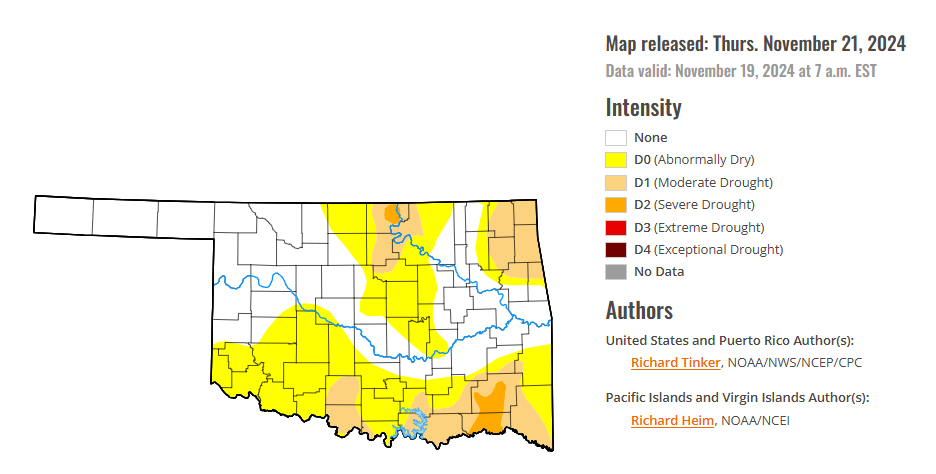
According to the latest Oklahoma drought monitor report, exceptional drought remains at zero percent, unchanged from the start of the calendar year.
Extreme drought or worse conditions remain at zero percent, unchanged for two weeks.
Severe drought or worse conditions have decreased to 1.85 percent, down from 9.38 percent last week.
Moderate drought or worse conditions have decreased to 17.90 percent, down from 47.05 percent last week.
Abnormally dry or worse conditions decreased to 52.78 percent, down from 81.78 percent last week.
According to the 6-to-10-day precipitation outlook map, the southern half of Oklahoma is leaning above a 33-40 percent chance of precipitation through November 30, 2024. Most of the state’s northern half is leaning above a 40-50 percent chance of precipitation, except for the Northwestern corner of the panhandle, which is leaning above a 50-60 percent chance of precipitation through that November 30 date.
To view the United States Drought Map, CLICK HERE.
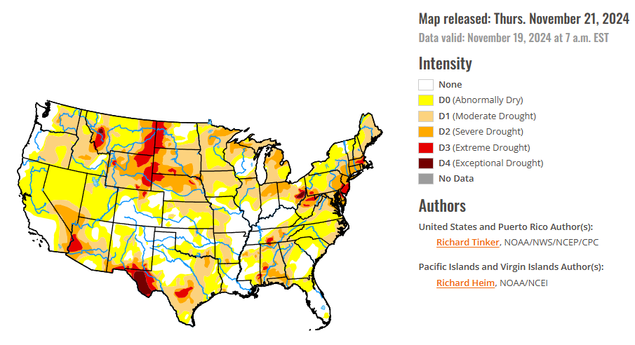
The trend of the past few weeks toward generally increased precipitation across the Contiguous 48 states continued this week, with several sizeable swaths of heavy precipitation recorded, and broad coverage of near or above-normal amounts. The heaviest amounts fell from the Cascades westward to the Pacific Ocean, in addition to southwestern Oregon and northwestern California. Amounts exceeded 3 inches through almost this entire region, with amounts of 5 inches to locally 1 foot observed in portions of the Cascades and immediate Pacific Coastline, especially where orographically enhanced. Several other large areas recorded at least an inch and locally up to 5 inches, including most of the northern Intermountain West, a swath from the southern High Plains through the central Great Plains and the middle and upper Mississippi Valley, much of the lower Mississippi Valley, the lower Ohio and Tennessee Valleys, the upper Southeast, much of the Virginia Tidewater and eastern North Carolina, and parts of the southern and central Appalachians. Numerous locations in the Lower Mississippi Valley and northwestern Alabama reported 3 to 5 inches of rain, as did a swath in north-central Kentucky and isolated spots in western Tennessee, northwestern Texas, eastern Oklahoma, southwestern Kansas, and western Iowa. The broad coverage of moderate to heavy precipitation prompted sizeable areas of improvement in this week’s Drought Monitor. The pattern of increased precipitation has yet to materialize in the Northeast, however, where record and near-record low precipitation amounts have been observed over the past few months, and continued dryness last week allowed conditions to continue to deteriorate. Little or no precipitation was also recorded across the southern reaches of South Carolina and Georgia, the Florida Peninsula, southern Texas, most of the central and northern Plains, and the southwestern quarter of the country, with patches of deterioration noted in these areas as well this week.
The Southern Plains experienced highly variable rainfall this past week, although more areas experienced significant rainfall and improved conditions than dryness and deterioration. The latter was confined to central and southern Texas where little or no rain fell, expanding D0 through much of Deep South Texas and prompting the introduction of D1 in a patch near the lower Rio Grande River. Farther north, moderate to heavy precipitation prevailed, especially across western Teas, much of Oklahoma, portions of Louisiana, Mississippi, and western Tennessee. A large part of these areas saw a 1-category improvement, nearly eliminating severe drought (D2) in western Arkansas, eastern Oklahoma, and adjacent Texas, and also decreasing D1 coverage substantially across the northern and eastern tiers of the Region.
In The High Plains, moderate to heavy precipitation was widespread across the southern and eastern reaches, and moderate amounts were observed in some of the higher elevations of Wyoming and central Colorado, and over northern North Dakota. Elsewhere, only a few tenths of an inch, at most, was measured. In the areas of heaviest precipitation (1.5 to approaching 3.0 inches), improvement was introduced. This included significant parts of Kansas, southeastern Colorado, eastern sections of Nebraska and South Dakota, and a relatively small area in southeastern North Dakota. The remainder of the region, under a regime of light to moderate precipitation at best, dryness and drought assessments were unchanged.
In the West, heavy to excessive precipitation in northwestern California and the Northwest from the Cascades to the Pacific Coast induced widespread 1-category improvement in these areas. Totals exceeding 3 inches were almost ubiquitous, and amounts of 5 to locally 12 inches were common in the Cascades and near the immediate coast. This amounted to peeling back D0 and D1 to the west. In Oregon, streamflows have finally begun to respond to the increased precipitation. Other areas of improvement were introduced where there was spottier moderate to heavy rain in parts of eastern Oregon, northern Idaho, and westernmost Montana. Moderate to heavy precipitation (locally up to 3 inches) also doused southeastern New Mexico adjacent to the heavy rains in western Texas, with similar 1-category improvements introduced in areas with over 1.5 inches of precipitation. Elsewhere, only scattered light precipitation was reported, and dryness and drought were primarily unchanged. Some deterioration was noted in west-central Montana (to D1) while a significant swath of eastern Montana slid into extreme drought (D3).
Looking ahead, during the next five days (November 21-25), moderate to heavy precipitation is expected in the western and northeastern quarters of the contiguous states, and along the immediate Canadian border. Lesser amounts, if any, are expected in and around the Plains and along most of the southern tier. The greatest amounts are forecast across northern California and the Sierra Nevada, where totals exceeding 5 inches are expected to be widespread, with the potential for as much as 15 inches at isolated spots in the higher elevations. Generally 1.5 to 3.0 inches are expected in the West from the Cascades to the Pacific Coast and in portions of the northern Intermountain West. Similar amounts are also forecast for most of New York State, northeastern Pennsylvania, and to a lesser extent New England, the Great Lakes, and southwestern California. Between 0.75 and 1.5 inches should fall in the remainder of the Northwest, the higher elevations of the central Rockies, southwestern California, much of the Great Lakes, Pennsylvania, Maryland and Delaware, and the rest of New England. In contrast, little or no precipitation is expected in the Plains from the central Dakotas southward, and along the southern tier of the country from southeastern California eastward through Georgia and most of the Carolinas. Very warm weather is expected in central and southern Texas, with temperatures expected to average 10 to 13 deg. F above normal. A larger area from eastern Arizona through the Lower Mississippi Valley is forecast to average 5 to 10 deg. F above normal. Meanwhile, unusually low temperatures averaging 10 to 17 deg. F below normal are anticipated from the central and western Dakotas through most of Montana. Temperatures may average up to 10 deg. F above normal from the Upper Mississippi Valley and central Plains westward through the Great Basin and northern Intermountain West. Near or slightly above normal temperatures are expected elsewhere.
The Climate Prediction Center’s 6-10 day outlook (valid November 26-30) favors above-normal precipitation in a swath from the Southwest and the Great Basin eastward through most of the Plains, and from Mississippi Valley eastward to the Atlantic Coast. Only the Northeast, Florida Peninsula, central and southern Texas, the Great Lakes, and the Far West are outside the area where above-normal precipitation is expected. Odds exceed 50 percent over the east-central Rockies and adjacent High Plains. Unusually dry weather is more likely in western Texas, the Northwest, parts of the Intermountain West, plus central and northern portions of the Rockies and Plains. Subnormal precipitation is also more likely across Hawaii, especially the northwestern islands. Meanwhile, the southern tier of the country from the Plains to the Atlantic Coast is expected to average warmer than normal, with odds topping 50 percent along and near the Gulf of Mexico Coast. Hawaii is also expected to average warmer than normal, especially the central and northwestern islands. Cold weather is favored across central and northern portions of the Rockies, Plains, and Mississippi Valley, plus some adjacent areas. Chances for significantly subnormal temperatures are 70 to 80+ percent from Montana east of the Rockies and most of the Dakotas.
To view the 6-10 Day Precipitation Outlook Map, click here.
To view the 6-10 Day Temperature Outlook Map, click here.
To view the Monthly Drought Outlook Map, click here.


