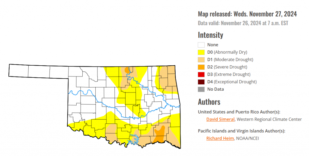
To view the latest Oklahoma drought map, CLICK HERE.
According to the latest Oklahoma drought monitor report, exceptional drought remains at zero percent, unchanged from the start of the calendar year.
Extreme drought or worse conditions remain at zero percent, unchanged for two weeks.
Severe drought or worse conditions are unchanged from last week at 1.85 percent.
Moderate drought or worse conditions have increased to 17.91 percent, up from 17.90 percent last week.
Abnormally dry or worse conditions decreased to 46.70 percent, down from 52.78 percent last week.
According to the 6-to-10-day precipitation outlook map, the southern portion of Oklahoma is leaning above a 33-40 percent chance of precipitation through December 7, 2024. Much of the central part of the state is near normal chances of precipitation. The eastern panhandle along with a portion of Northwest Oklahoma is leaning below a 33-40 percent chance of precipitation, and the western panhandle is learning below a 40-50 percent chance through that December 7 date.

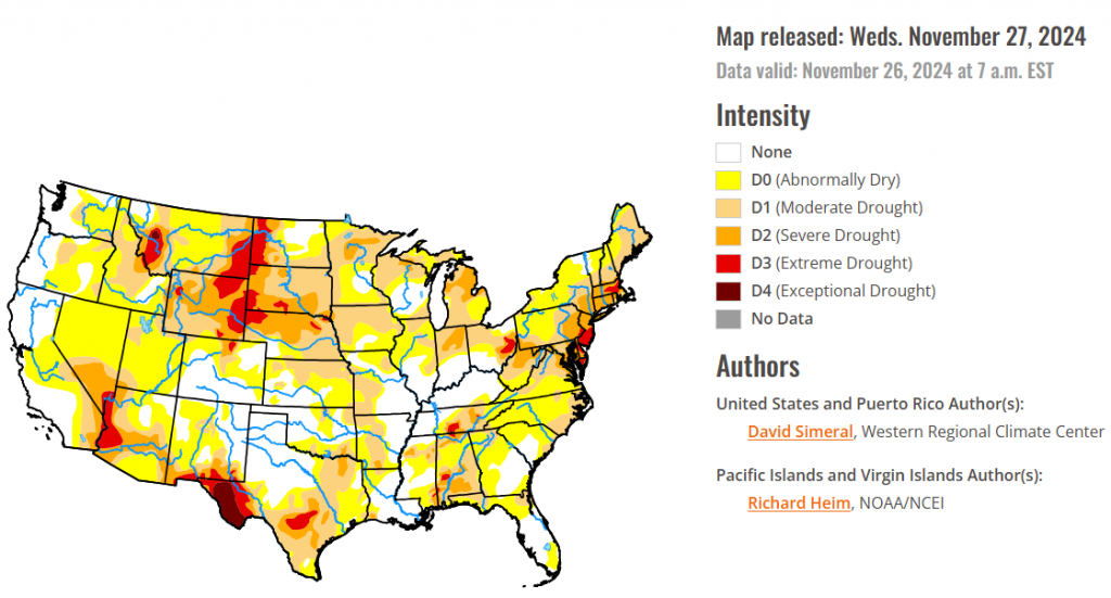
To view the United States Drought Map, CLICK HERE.
This U.S. Drought Monitor (USDM) week saw widespread improvement in drought-related conditions across areas of the Pacific Northwest and Northern California in response to a series of strong Pacific storms including a powerful atmospheric river that delivered significant rainfall accumulations to the lower elevation coastal areas and heavy mountain snow. In the coast ranges of Northern California, 7-day rainfall totals exceeded 25+ inches in some areas, according to preliminary data from the National Weather Service (NWS) California-Nevada River Forecast Center. The series of storms boosted mountain snowpacks above normal levels across the Cascades (Oregon, Washington), Blue Mountains (Oregon), Sawtooth Range (Idaho), and the northern and central Sierra. In the Desert Southwest, drought expanded and intensified on the map across areas of southern Nevada and Arizona in response to persistent dry conditions and record-warm temperatures during the past 6-month period. In the Midwest, improving short-term conditions due to recent precipitation events across areas of the region led to widespread improvements in drought-affected areas. In the Northeast, light-to-moderate precipitation accumulations, including beneficial snowfall, led to a reduction of areas of drought coverage in Pennsylvania and West Virginia. In the Southeast, rainfall last week and overall improving conditions (soil moisture, streamflows) led to the removal of areas of drought on the map in Alabama, Georgia, and Florida.
In terms of reservoir storage in areas of the West, California’s reservoirs continue to be at or above historical averages for the date (November 25) with the state’s two largest reservoirs (Lake Shasta and Lake Oroville) at 111% and 105% of their averages, respectively. In the Southwest, Lake Powell is currently 37% full (59% of typical storage level for the date) and Lake Mead is 32% full (53% of average), with the total Lower Colorado system 42% full as of November 18 (compared to 43% full at the same time last year), according to the U.S. Bureau of Reclamation. In Arizona, the Salt River Project is reporting the Salt River system reservoirs 75% full, the Verde River system 57% full, and the total reservoir system 73% full (compared to 81% full a year ago). In New Mexico, the state’s largest reservoir along the Rio Grande is currently 7% full (17% of average). In the Pacific Northwest, Washington’s Franklin D. Roosevelt Lake is 90% full (103% of average for the date), Idaho’s American Falls Reservoir on the Snake River is 35% full (86% of average), and Hungry Horse Reservoir in northwestern Montana is 82% full (100% of average).
In the Southern Plains, generally dry conditions prevailed this week, especially in the western portion of the region, with little or no precipitation observed across the western half of Texas and Oklahoma. However, light to moderate rainfall (2 to 4+ inches) was observed in isolated areas of southern Louisiana and Mississippi leading to minor improvements in drought-affected areas of southeastern Mississippi. For the week, average temperatures were near normal across the southern extent of the region while northern portions ranged from 3 to 6 degrees F above normal. On the map, deterioration occurred in isolated areas of Texas including the Trans Pecos, South Texas, and the southern Edwards Plateau, while improvements were made in the Panhandle and east Texas. Looking at reservoir conditions in Texas, Water for Texas (November 26) was reporting statewide reservoirs at 72% full, with many reservoirs in the eastern part of the state in good condition, while numerous reservoirs in the western portion of the state were experiencing continued below-normal levels.
In The High Plains, moderate to heavy precipitation was widespread across the southern and eastern reaches, and moderate amounts were observed in some of the higher elevations of Wyoming and central Colorado, and over northern North Dakota. Elsewhere, only a few tenths of an inch, at most, was measured. In the areas of heaviest precipitation (1.5 to approaching 3.0 inches), improvement was introduced. This included significant parts of Kansas, southeastern Colorado, eastern sections of Nebraska and South Dakota, and a relatively small area in southeastern North Dakota. The remainder of the region, under a regime of light to moderate precipitation at best, dryness and drought assessments were unchanged.
In the West, a series of powerful Pacific storms delivered heavy rain and mountain snow accumulations to the Pacific Northwest and Northern California. Impacts from the series of storms included damaging winds, major power outages, flash flooding, road closures, landslides, and debris flows. In the Coastal Range, an NWS observing station northwest of Santa Rosa, California reported a 7-day total of 24 inches of rain. Overall, the series of storms led to widespread removal of areas of drought on the map across the Pacific Northwest as well as areas experiencing short-term dryness across Northern California. Looking at the regional snowpack situation, the NRCS SNOTEL network is reporting (November 25) the following region-level (2-digit HUC) SWE levels: Pacific Northwest 179%, Missouri 78%, Upper Colorado 96%, Great Basin 125%, Lower Colorado 127%, Rio Grande 145%, Missouri 78%, Souris-Red-Rainy 128%, and Arkansas-White-Red 157%. In the Desert Southwest, areas of Extreme Drought (D3) expanded on the map this week in northwestern Arizona, extending northward into southern Nevada, in response to a combination of short and long-term precipitation deficits and record heat observed during the past 6-month period. Elsewhere in the region, the atmospheric river last week boosted snowpack conditions in Montana, helping to improve drought-affected areas in the northwestern part of the state.
Looking ahead, the NWS Weather Prediction Center (WPC) 7-Day Quantitative Precipitation Forecast (QPF) calls for light-to-moderate precipitation accumulations ranging from 1 to 2 inches (liquid) across areas of the Intermountain West including the Colorado Rockies and ranges in central and southern Utah. Lighter accumulations are expected in the southern Sierra, North Cascades, and areas of the northern Rockies. Along the Gulf Coast of Texas and Louisiana, light accumulations (<1 inch) are forecasted for the 7-day period. In the Upper Midwest and areas downwind of the Great Lakes in the Northeast, accumulations of <1 inch are expected. The Climate Prediction Center (CPC) 6-10-day Outlook calls for a moderate-to-high probability of above-normal temperatures across the West and near-normal temperatures across the Plains states. Conversely, below-normal temperatures are expected across the Eastern tier. In terms of precipitation, there is a low-to-moderate probability of above-normal precipitation across much of Texas and Louisiana as well as areas of the northern Plains. Elsewhere, below-normal precipitation is expected across much of the West, Central and Southern Plains, Southeast, Mid-Atlantic, and New England.
To view the 6-10 Day Precipitation Outlook Map, click here.
To view the 6-10 Day Temperature Outlook Map, click here.
To view the Monthly Drought Outlook Map, click here.


