

To view the latest Oklahoma drought map, CLICK HERE.
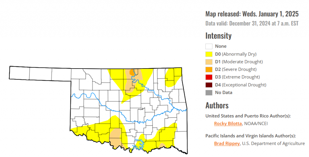
According to the latest Oklahoma drought monitor report, exceptional drought remains at zero percent, unchanged from the start of the calendar year.
Extreme drought or worse conditions remain at zero percent, unchanged since the week of October 29.
Severe drought or worse conditions decreased to 0.33 percent, down from 0.59 percent last week.
Moderate drought or worse conditions decreased to 5.52 percent, down from 11.54 percent last week.
Abnormally dry or worse conditions decreased to 29.72 percent, down from 43.22 percent last week.
According to the 6-to-10-day precipitation outlook map, Western Oklahoma, except for the panhandle, is leaning near normal chances of precipitation through January 11, 2025. The Panhandle is leaning above 33 – 40 percent chances of precipitation. Most of the Eastern half of the state is leaning below 33 – 40 percent chances of precipitation, except for the southeast corner which is leaning below 40 – 50 percent chances of precipitation through that January 11, 2025 date.

To view the United States Drought Map, CLICK HERE.
Precipitation fell across much of the U.S. this week, with heavier amounts (> 1 inch) falling across large portions of the Northwest U.S. and from south-central U.S. to the Ohio Valley. Coastal areas of the Pacific Northwest, from Washington to northern California, reported weekly rainfall totals between 2 to 15 inches, while precipitation totals of 2 to 10 inches were reported in areas from eastern Texas to Alabama, as well as parts of the Ohio Valley and the Southeast. Above-normal precipitation supported drought improvements across large portions of the South and Midwest, and in parts of the Pacific Northwest, Midwest and Southeast. Conversely, weekly precipitation totals were below normal in areas of the southwestern U.S., Mid-Atlantic and Northeast. Drought and abnormal dryness were expanded or intensified in portions of the Southwest and in small pockets of the High Plains. Temperatures were above normal across much of the U.S. this week. Areas along the Northern Tier, from northern portions of the West, to the Midwest observed temperatures 10 to 25 degrees above normal. Below-normal temperatures were reported across northern portions of the Northeast, from northern New Jersey to Maine, where departures were up to 5 degrees F below normal this past week. Below-normal temperatures were also observed in small pockets of the Southeast this week.
In the Southern Plains, heavy rainfall was observed this week, with precipitation totals ranging between 1 to 8 inches above normal. Above-normal rainfall, with amounts up to 600% above normal, along with improvements shown in short-term SPI/SPEI, streamflow and soil moisture data, supported widespread improvements to drought made from eastern Texas to Mississippi this week. Severe drought was removed along the Oklahoma-Texas and Louisiana-Arkansas borders, as well as from southern Mississippi, and improved in central Texas. Moderate drought was improved over large portions of Arkansas, eastern Texas, and in parts of Oklahoma, Louisiana and Mississippi. Conversely, western portions of Oklahoma and Texas observed below-normal precipitation this week. Moderate drought and abnormal dryness were expanded in small parts of western Texas. Temperatures were above normal across the entire region this week, with departures ranging between 1 to 15 degrees F above normal.
In The High Plains, warm temperature dominated this week, with departures ranging up to 20 degrees F above normal, especially along the northern portions of the region. Precipitation fell across much of the region this week, but amounts were not large enough to justify large improvement across much of the High Plains. Extreme drought was expanded in northern Nebraska, while moderate drought was expanded in southeast Kansas. Abnormal dryness was expanded in southwest Colorado, where weekly rainfall totals are 5% to 20% or normal for the week. Small areas of the region did observe heavy rainfall, where rainfall totals were more than an inch above normal. This above-normal precipitation allowed for improvements to be made in South Dakota and along the Wyoming-Colorado border. Moderate to extreme drought were improved in northern Colorado and southern Wyoming, while severe drought was improved in western South Dakota. Abnormal dryness was also improved in areas along the Wyoming-Colorado border this week.
In the West, average temperatures were above normal across nearly the entire region this week, while small pockets of below-normal temperatures were observed in northern California and along the southern coast of California, where temperatures were between 1 to 3 degrees F below normal. Conversely, Montana observed temperatures ranging between 6 to 15 degrees F above normal this week. Precipitation varied across the region this week, with heavy amounts falling in northern portions, while some areas in the southern portions of the region observed no precipitation. In the north, precipitation amounts of 1 inch or greater fell across much of the Pacific Northwest and northern California, with some areas receiving up to 8 inches above normal for the week. Moderate to severe drought were improved in western Montana and eastern Idaho, while moderate drought was removed in southeast Oregon and trimmed in the northeastern part of the state. Abnormal dryness was improved in northeast Oregon and in small parts of eastern Washington and southern Idaho. In the southern part of the region, above-normal temperatures and below-normal precipitation resulted in expansion of drought in Arizona, California and Nevada. Extreme drought was expanded in southern Arizona, while severe drought was expanded in southern and northwestern parts of the state. Moderate drought was expanded in western and eastern Nevada, southern California and across parts of Arizona, while abnormal dryness was expanded in parts of California, Arizona, Utah, Colorado and New Mexico this week.
Looking ahead, during the next five days (December 31, 2024–January 4, 2025), a low-pressure system tracking from the Ohio Valley into the Northeast will spread precipitation across those regions Tuesday-Wednesday. Precipitation should fall as rain for most of the Ohio Valley to the coastal areas/lower elevations of the Northeast. Snow is likely in the higher elevation areas of the Interior Northeast like the Adirondacks and the Green and White Mountains. The Pacific Northwest will see a relative break in precipitation on Tuesday after a steady train of atmospheric rivers into the region. But by Tuesday night or Wednesday, moist inflow may get renewed there and rounds of precipitation are likely to continue through late week and at times farther east into the northern Rockies. The eastern U.S. can expect one more day of above-average temperatures (by 10-15F) on Tuesday before upper troughing pushes along a series of cold fronts that gradually cool temperatures to near normal on Wednesday and gradually below normal into late week. High temperatures by Saturday are forecast to be around 10-15F below normal for the Ohio Valley to Appalachians and Mid-Atlantic while lows should be 5-10F below average. Colder than-normal temperatures will also impact the north-central U.S., and lows could reach 10-15F below zero over northern North Dakota and Minnesota by Friday and/or Saturday. Meanwhile, the amplifying upper ridge over the West will promote warming, with temperatures generally 5-10F above average increasing in coverage by the second half of the week. Locally higher anomalies are likely in the Southwest and highs could reach well into the 70s. Highs of 5-15F above normal may reach into the southern High Plains by next Saturday.
The Climate Prediction Center’s 6-10 day outlook (valid January 5–9, 2025) favors above-normal precipitation across much of the U.S., with below-normal precipitation favored in portions of the Southwest and Northeast, as well as parts of northern Alaska and on southern parts of the Big Island. Increased probabilities for above-normal temperatures are forecast for Hawaii and across much of the West and Alaska, while below-normal temperatures are likely from the northern Rockies to the East Coast, and in northern parts of Alaska.
To view the 6-10 Day Precipitation Outlook Map, click here.
To view the 6-10 Day Temperature Outlook Map, click here.
To view the Monthly Drought Outlook Map, click here.


