

To view the latest Oklahoma drought map, CLICK HERE.
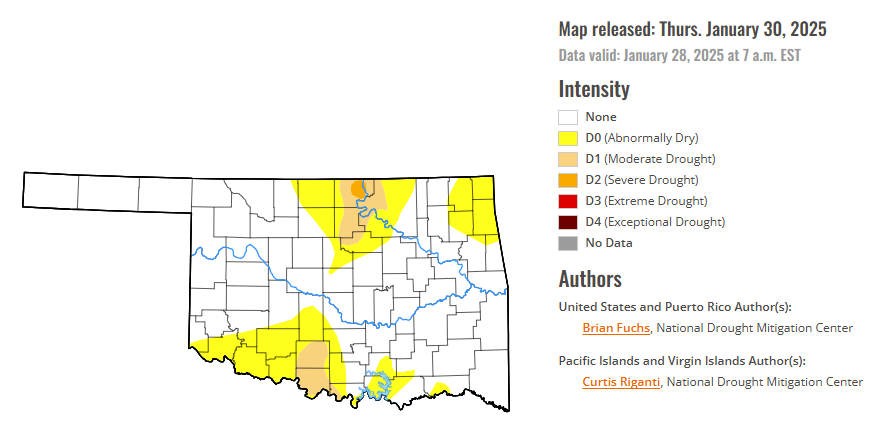
According to the latest Oklahoma drought monitor report, exceptional drought remains at zero percent, unchanged from the start of the calendar year.
Extreme drought or worse conditions remain at zero percent, unchanged since the week of October 29, 2024.
Severe drought or worse conditions are unchanged at 0.33 percent, since January 2.
Moderate drought or worse conditions are unchanged from 5.24, since January 16.
Abnormally dry or worse conditions are unchanged from 26.11 percent, since last week.
According to the 6-to-10-day precipitation outlook map, the Western panhandle is leaning below a 33 – 40% chance of precipitation through February 8. The Western corridor of Oklahoma is near normal chances of precipitation. Most of Central and Eastern Oklahoma are leaning above a 33-40% chance of precipitation. A small corridor in Northwest Oklahoma is leaning above a 40-50% chance of precipitation through that February 8 date.
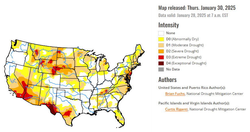
To view the United States Drought Map, CLICK HERE.
A dry week dominated the weather over much of the country with only portions of southern California and in the South along the Gulf Coast recording significant precipitation for the week. The current week started with a significant, even historical, winter storm event that impacted the coastal areas of the Gulf Coast. Several locations set all-time records for snow amounts with some locations in Louisiana having 9-10 inches of snow for the event. Some locations in the Florida panhandle also recorded 6-9 inches of snow during this event. Colder-than-normal temperatures dominated the country with the coldest readings in the Southeast, where departures were 10-15 degrees below normal, and in the northern Rocky Mountains with similar departures from normal. Portions of the northern Plains were warmer than normal, with temperatures 5-10 degrees above normal in the Dakotas and into portions of eastern Montana and western Minnesota.
In the Southern Plains, most of the region was dry for the week outside of those areas impacted by the winter storm that traversed across the Gulf Coast areas of Texas and into central Louisiana and Mississippi. Temperatures were cooler than normal over the entire region with the greatest departures over southern Louisiana into Mississippi where temperatures were 12-16 degrees below normal. Improvements were made to the abnormally dry conditions in Mississippi and in portions of east Texas. Severe and extreme drought was expanded in southern Texas with regards to the long-term drought signals in place, especially on the hydrologic systems in the region. Dryness continues in Tennessee with degradation in the southern, middle and eastern potions of the state as moderate, severe and extreme drought all expanded this week.
In The High Plains, Northern areas were warmer than normal with departures of 3-9 degrees above normal in the Dakotas and northeastern Montana. Colder-than-normal temperatures dominated the rest of the region with some areas of Wyoming 12-15 degrees below normal for the week. Areas of western South Dakota, southwest North Dakota, southeast Montana and northeast Wyoming improved this week as conditions over the last few months were reassessed and the indicators were not aligning with the drought depiction. In many instances the drought is still considered severe or worse, but where the intensity was reduced, it was due to not all the indicators converging to what was being shown. In Wyoming, conditions were improved in the central and southwest where severe and moderate drought as well as abnormally dry conditions were improved. Some extreme drought was extended in the Wind River where snow and precipitation numbers supported the change.
In the West, temperatures were colder than normal over almost the entire region, with departures of 9-12 degrees below normal in the northern Rocky Mountains and 3-6 degrees below normal most other places. Most of the region was drier than normal this week with only some areas of southern California, western Arizona and eastern Montana recording above-normal precipitation. The dryness allowed for the expansion of moderate drought into the central valley of California where the water year has continued to be drier than normal. In Arizona, the winter continues to be on the dry side and allowed for the expansion of moderate, severe and extreme drought conditions over the western, northern and southern portions of the state. In Nevada, moderate and severe drought were expanded over the eastern part of the state and were also expanded in the southern portions of Utah. Abnormally dry and moderate drought conditions expanded over western Washington and abnormally dry conditions were filled in over northwest Montana. In Colorado, abnormally dry conditions and moderate drought expanded over the west, south and southwest portions of the state with a new area of severe drought added in the south.
Looking ahead, over the next five to seven days, it is anticipated that some of the coastal areas of the Pacific Northwest could see some dryness alleviated with rains from northern California to Washington. Precipitation chances appear to be good over the northern and central Rocky Mountains. The most active rainfall pattern is expected to be from the southern Plains into the Midwest and Mid-Atlantic where some areas of Texas, Oklahoma, and Arkansas will see 2-3 inches of rain. Dry conditions will continue in the Southwest and northern Plains along with most of the Florida peninsula.
The 6-10 day outlooks show that the probability of below-normal temperatures is greatest in the Pacific Northwest and across the northern part of the United States into the High Plains. The best chances of above-normal temperatures will be over the Four-Corners region and along the southern tier of the U.S. into the Southeast and Mid-Atlantic. The greatest chances of above-normal precipitation will be over northern California into the Great Basin and the northern Rocky Mountains as well as over the Midwest. The best chances of seeing below-normal precipitation are over the Southwest and along the Gulf Coast of Florida.
To view the 6-10 Day Precipitation Outlook Map, click here.
To view the 6-10 Day Temperature Outlook Map, click here.
To view the Monthly Drought Outlook Map, click here.


