

To view the latest Oklahoma drought map, CLICK HERE.
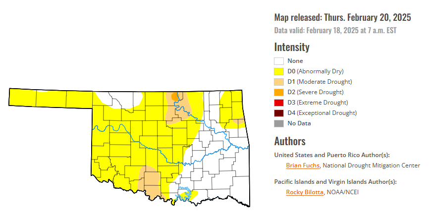
According to the latest Oklahoma drought monitor report, exceptional drought remains at zero percent, unchanged from the start of the calendar year.
Extreme drought or worse conditions remain at zero percent, unchanged since the week of October 29, 2024.
Severe drought or worse conditions are unchanged at 0.33 percent, since January 2.
Moderate drought or worse conditions are unchanged at 7.75 percent, since February 6.
Abnormally dry or worse conditions are unchanged at 65.73 percent, since last week.
According to the 6-to-10-day precipitation outlook map, the entire state is leaning below a 40-50% chance of precipitation through March 1, 2025.
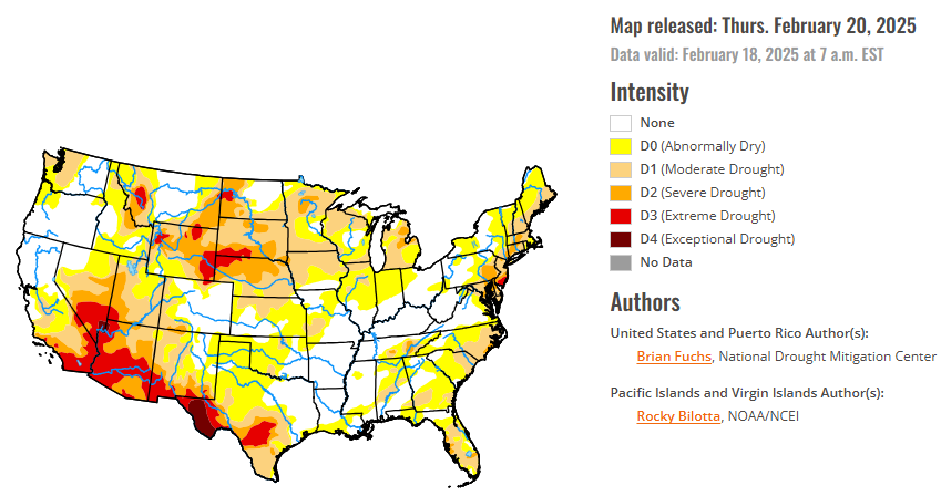
To view the United States Drought Map, CLICK HERE.
A significant storm system moved through the South and into the Southeast during the week, which was associated with flooding rains over the Tennessee Valley and into Kentucky where some of these areas recorded 7-8 inches of rain or more. Portions of northwest Tennessee had CoCoRaHS reports of over 10 inches of rain over the previous week, with the greatest amount of 11.35 inches outside of Clarksville, TN. Many reports of 3 or more inches of rain were observed from northern Louisiana up to southern Virginia with pockets of northern South Carolina with widespread 6+ inches of rain recorded. With recent dryness and a prolonged rain event, many areas had good infiltration into the soil and even some runoff which helped the local hydrological conditions. The Northern and Southern Plains were mostly dry, with areas of east Texas seeing some benefits of rain. Rain returned to the lower elevations of California and up the West Coast as well as snow in the upper elevations in the West. Temperatures were colder than normal over most of the country, with the greatest departures over Montana and North Dakota where temperatures were greater than 25 degrees below normal. The warmest areas this week were in the Southwest and Southeast, where temperatures were near normal in the Southwest and 5-10 degrees above normal in Florida and southern Georgia.
In the Southern Plains, the cold from the north made its way into the region with most areas of Oklahoma, north Texas and northern Arkansas all being below normal for temperatures with departures of 6-12 degrees below normal. Areas of central to east Texas, eastern Oklahoma and most areas east of here had the greatest precipitation this week, with some areas of northeast Arkansas and northern Mississippi and Louisiana at greater than 800% of normal. Much of central and western Oklahoma and southern, western and northern Texas were dry this week. Improvements to moderate drought and abnormally dry conditions were made over northern Mississippi and northern Louisiana. A full category improvement was made to all drought and abnormally dry conditions in Tennessee. It was suggested that some of these areas could see more improvement and it was hoped that the hydrological response would allow for this in the coming weeks. The areas that missed out on the rain again did see some degradation, which included the expansion of severe and extreme drought in south Texas and abnormally dry conditions expanded in southern Louisiana.
In the High Plains, the wettest areas were from eastern Colorado into western Kansas and most of Nebraska where over 200% of normal precipitation was measured. The driest areas were in North Dakota and South Dakota as well as in southern Kansas. It was a cold week for the region with areas of western North Dakota recording departures from normal of 25 degrees or more. Almost all of the High Plains were at least 15 degrees below normal for the week. Only a few slight changes occurred in the region this week, with far southeast Nebraska and far northeast improvements to Kansas’ abnormally dry and moderate drought conditions and abnormally dry conditions removed from northeast Colorado along the Kansas and Nebraska borders..
In the West, widespread precipitation occurred over much of the region with only pockets of Nevada, Utah, Wyoming, southern California, southern Arizona and New Mexico missing out. Temperatures were below normal for the region outside of the southern deserts of California, Arizona, and New Mexico where they were near to slightly above normal. The coldest air was over Montana and into Wyoming where departures were greater than 25 degrees below normal. The wetter conditions over California allowed for some improvements in areas where the current water year indicators improved and eased some of the drought conditions. In Washington, continued dryness allowed the expansion of moderate drought in the western portions of the state. Nevada had degradation along the eastern areas, where severe drought expanded, while improvements were made to the moderate drought and abnormally dry conditions of western Nevada. Severe drought expanded over more of western Utah while extreme drought expanded into more of southern Arizona. The last few months have been dry over much of New Mexico coming off a wetter period prior. In looking at the values for the current water year, most areas were holding status quo but degradation to the drought status was made in southwest New Mexico into south-central areas of the state. In Colorado, several small snow events occurred, which allowed for some chipping away at the drought designations as conditions showed some improvement. In southwest Colorado, moderate and severe drought improved and in western areas, abnormally dry and moderate drought improved. Northern Colorado continued to have a sharp gradient of areas where drought has developed, and some improvements were made here this week into southern Wyoming. Western areas of Wyoming continue to record better snowfall totals, improving the upper-elevation snow numbers for this season. Improvements were made to the abnormal dryness and moderate drought in southern and western Wyoming while in northwest Wyoming, severe and extreme drought improved this week. With the active pattern over Montana as well, the recent improvements made over the last several weeks allowed for minimal changes with only some improvements to moderate drought over western Montana.
Looking ahead over the next five to seven days, it is anticipated much of the area in the Southeast and into portions of the South will see additional precipitation with some areas that missed out on the last event potentially recording up to an inch of precipitation with this next storm system. Areas along the East Coast also are anticipated to see additional precipitation while much of the Pacific Northwest and into the northern Rocky Mountains is anticipated to see additional precipitation during this period. Much of the Plains, Midwest and Southwest are anticipated to be dry. In a reversal of recent weeks, warmer-than-normal temperatures are expected over much of the area from the Plains westward with departures of 13-16 degrees above normal over much of the Southwest. The areas east of the Plains are anticipated to be near normal.
The 6-10 day outlooks show the high probability of warmer-than-normal temperatures over the western half of the country, with the best probability of above-normal temperatures over the Southwest and portions of the High Plains. The greatest chances of below-normal temperatures will be over Florida. The greatest probability of above-normal precipitation will be along the Canadian border with the best chances of above-normal precipitation in portions of the High Plains, Midwest and New England. Above-normal chances of below-normal precipitation will be over much of the West, southern Rocky Mountains and southern Plains.
To view the 6-10 Day Precipitation Outlook Map, click here.
To view the 6-10 Day Temperature Outlook Map, click here.
To view the Monthly Drought Outlook Map, click here.


