

To view the latest Oklahoma drought map, CLICK HERE.
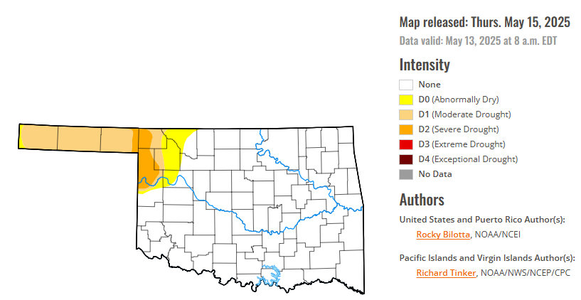
According to the latest Oklahoma drought monitor report, exceptional drought remains at zero percent, unchanged from the start of the calendar year.
Extreme drought or worse conditions remain at zero percent, unchanged since the week of October 29, 2024.
Severe drought or worse conditions have decreased to 2.99 percent, down from 6.91 percent last week.
Moderate drought or worse conditions have decreased to 11.94 percent, down from 13.95 percent last week.
Abnormally dry or worse conditions have decreased to 15.52 percent, down from 24.91 percent last week.
According to the 6-to-10-day precipitation outlook map, the panhandle of Oklahoma, is near normal chances of precipitation through May 24. The Southeastern portion of the state is leaning above a 40-50% chance of precipitation through May 24. The rest of the state is leaning above a 33-40% chance of precipitation through that May 24 date.
To view the United States Drought Map, CLICK HERE.
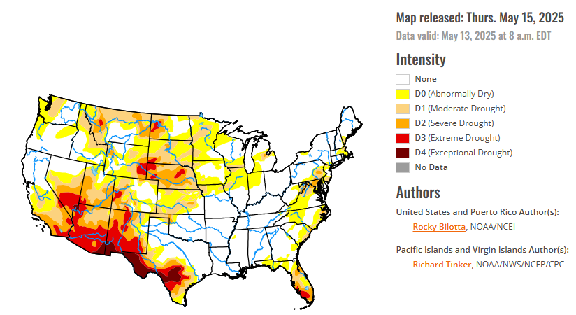
Precipitation fell across much of the U.S. this week, with heavier amounts (> 1 inch) falling from portions of the central and southern Plains eastward to the East Coast, and also in parts of the West, Hawaii, and southern Alaska. Much of the Southeastern U.S., from eastern Texas to North Carolina, reported weekly rainfall totals between 2 to 10 inches, while similar amounts (2 to 6 inches) were reported in parts of the Northeast. Above-normal precipitation supported drought improvements across large portions of the South, Southeast and Northeast, and in parts of the Southwest and High Plains. Conversely, weekly precipitation totals were below normal across much of the West to the Midwest. Drought and abnormal dryness were expanded or intensified in northern portions of the West and Midwest, as well as parts of the Southwest and High Plains. Temperatures were above normal across much of the U.S. this week, with areas of the north-central U.S., from central Montana to Minnesota, reported temperatures 9 to 20 degrees above normal. Below-normal temperatures were observed from the southern Plains to parts of the eastern Midwest, where departures were up to 10 degrees F below normal, with the largest departures being reported in parts of Texas.
In the Southern Plains, cooler temperatures dominated this week, with departures ranging up to 9 degrees F below normal. However, small areas of Texas, Oklahoma, Mississippi, and Tennessee observed temperatures slightly above normal this week, with temperatures between 1 to 3 degrees F above normal. Precipitation varied across the region this week, with heavier amounts (1 to 8 inches) falling across much of Louisiana and Mississippi, and in parts of Oklahoma, Texas, and southern Arkansas. Moderate to exceptional drought (D1-D4) was improved in parts of western, central, and southern Texas, while moderate to severe drought (D1-D2) was improved in western Oklahoma. Improvements to abnormal dryness (D0) were made in Oklahoma and Texas, and abnormal dryness was removed from southern Mississippi and southern Louisiana. Drought reduction and improvements were based on precipitation totals, short-term SPI/SPEI, NDMC short-term blends, and improvements to streamflow and soil moisture data.
In the High Plains, warm temperatures dominated the High Plains this week, with departures ranging up to 20 degrees F above normal, especially along the northern portions of the region, while cooler-than-normal temperatures were observed along the southern border. Precipitation fell across the western and southern portions of the region this week; however, in most areas, amounts were insufficient for significant improvement. Beneficial heavy precipitation (1 to 3 inches) in eastern Colorado and Kansas led to improvements in moderate to severe drought (D1-D2) and abnormal dryness (D0) in these areas. Conversely, dry conditions resulted in the introduction and expansion of drought. Extreme drought (D3) was introduced in western Nebraska, and moderate to extreme drought (D1-D3) expanded in western Colorado and eastern Nebraska. Abnormal dryness was also expanded in southern Wyoming this week.
In the West, average temperatures were above normal across nearly the entire region this week, while below-normal temperatures were observed across much of New Mexico, and in parts of Arizona and along the coast of Washington, Oregon, and California, where temperatures were between 1 to 6 degrees F below normal. Conversely, Montana observed temperatures ranging between 3 to 15 degrees F above normal this week. Precipitation varied across the region this week, with beneficial amounts falling in parts of the Southwest and southern Montana. Exceptional drought (D4) was improved along the Nevada-Arizona border, while extreme drought (D3) was trimmed back in southern Utah, southern Nevada, eastern California, and western Arizona. Severe drought (D2) was improved in parts of Utah, Arizona, while moderate drought (D1) was reduced in Montana. Conversely, above-normal temperatures and below-normal precipitation resulted in the expansion of exceptional drought in southern New Mexico, severe drought in Montana, and moderate drought in northern portions of Washington, Idaho and Montana. Abnormal dryness (D0) was also expanded in western Washington, northeast Oregon, northern and southern Idaho, and in southern California this week.
Looking ahead, during the next five days (May 13–17, 2025), the slow-moving upper low across the Southeast U.S. will be weakening and evolving into an open trough by Thursday as it exits the East Coast. Another upper trough and closed low across the Northern Rockies mid-week will sustain a surface low crossing the Northern Plains and then into south-central Canada by the end of the week, with heavy rain for the Dakotas/Minnesota and late-season mountain snow for the northern Rockies. Going into Thursday, the heavier rainfall reaches eastern North Dakota into northern Minnesota, with some of the guidance indicating the potential for 1-2 inch rainfall totals with some embedded convection. Very warm weather will continue across the Upper Midwest for the middle of the week, with highs reaching 85-90 degrees on Wednesday across the eastern Dakotas and much of Minnesota. The anomalous warmth then shifts eastward to the Great Lakes and Ohio Valley regions to close out the week, and much of the East Coast Friday into Saturday ahead of the cold front. Very hot conditions are expected across southern Texas for the entire forecast period with highs exceeding 100 degrees near the Rio Grande, and HeatRisk reaching the major category for these areas. In contrast, chilly conditions are likely for the Intermountain West and Northern Rockies with highs running 5-15 degrees below average with the upper-level trough and increased cloud cover.
The Climate Prediction Center’s 6-10 day outlook (valid May 18–22, 2025) favors above-normal precipitation across most of the U.S., with below-normal precipitation favored in portions of the West Coast states and the Florida Peninsula. Increased probabilities for above-normal temperatures are forecast for Hawaii, from the southern Plains to the Southeast, and in parts of California, Nevada, and southern Alaska.
To view the 6-10 Day Precipitation Outlook Map, click here.
To view the 6-10 Day Temperature Outlook Map, click here.
To view the Monthly Drought Outlook Map, click here.


