

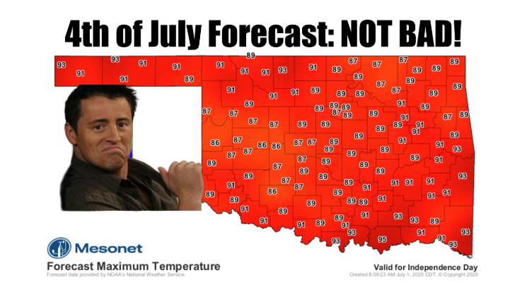
Oklahomans are preparing for a “really hot” Fourth of July holiday, according to State Climatologist Gary McManus, marking a stark shift from a June that delivered record-breaking rainfall and, for the first time in nearly six years, completely eradicated drought from the state.
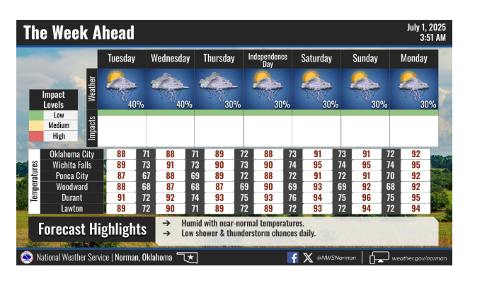
“This coming Friday will be a gift with highs in the 80s, mostly,” McManus noted, offering a brief respite before the holiday heat intensifies. While heat index values will creep into the 90s, he added, “all this week, not bad. Not bad at all.” However, he warned of the impending heatwave for the holiday, stating, “Next week… not as not bad, but it still could be worse.” He anticipates a slight calming of the rain, despite recent heavy downpours. “It does look like the rain will calm down just a bit. It got out of hand last night. Again. There will be rain chances, but nothing on the too-heavy side, at least the way it looks now. So to sum up, not too bad (except for fireworks!).”
June: A Month of Extremes and Relief
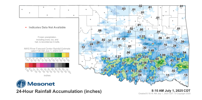
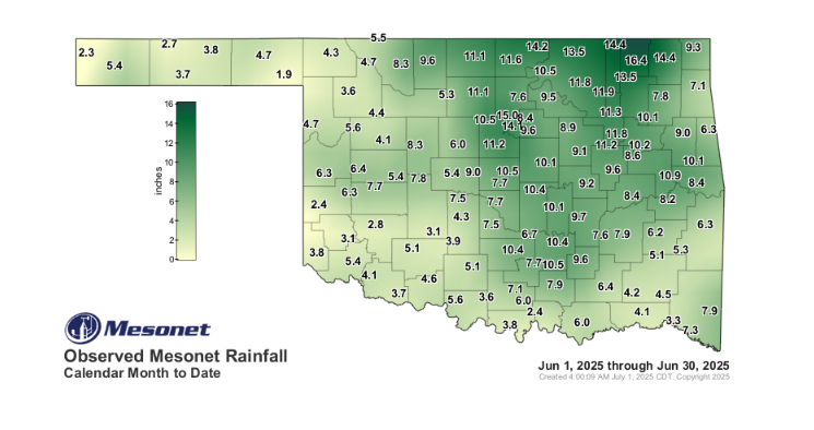
June 2025 proved to be a remarkable month for Oklahoma’s weather, overwhelmingly dominated by “tornadoes and heavy rains,” as McManus described. The month concluded as the sixth-wettest June on record, with a statewide average of 7.22 inches of precipitation, nearly 3 inches above normal. The state also experienced a significant surge in preliminary tornado counts, reaching 25 – just three shy of the June 1995 record.
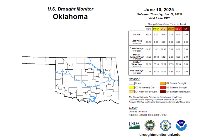
However, the silver lining to this active weather was the long-awaited elimination of drought. “June saw drought completely eliminated from Oklahoma for the first time in nearly six years,” McManus announced. The U.S. Drought Monitor confirmed that no drought (D1-D4) existed in Oklahoma as of June 3, a milestone not seen since July 23, 2019. By the following week, all abnormally dry conditions (D0) were also gone, marking an end to a drought episode that began in August 2021 and peaked on October 1, 2022, when 86% of the state experienced extreme drought or worse.
Record Tornado Activity
The 25 confirmed tornadoes in June contribute to a preliminary total of 86 for January through June 2025, significantly surpassing the state’s long-term annual average of 58.8. While most of June’s tornadoes were weaker EF0 or EF1 categories, some caused notable damage. An EF1 twister struck McAlester on June 7, badly damaging downtown brick buildings, homes, and businesses. The month’s strongest tornado was an EF2 that touched down in Ellis County, near Arnett, traveling 12 miles into Roger Mills County with a width of at least 500 yards.
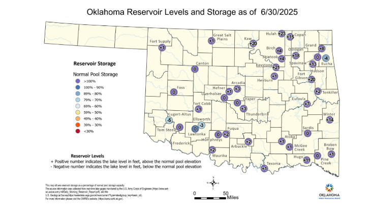
Saturated Soils and Full Lakes
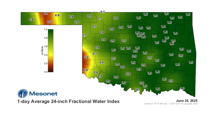
The abundant rains of June, building on record totals from April and heavy May precipitation, have led to significantly swollen bodies of water across Oklahoma. “Some reservoirs reported levels more than 20 feet above the conservation pool,” McManus stated, highlighting the dramatic turnaround. Even the perennially dry lakes of southwest Oklahoma are now approaching normal levels. The Oklahoma Mesonet’s soil moisture sensors indicate “near-saturated conditions in the top two feet of soil across most of the state,” which is a crucial factor in keeping temperatures down. “To have that soil moisture up as we get into July… is always a great thing because that tends to keep us cooler,” McManus added.
Looking Ahead: Heat but No Drought
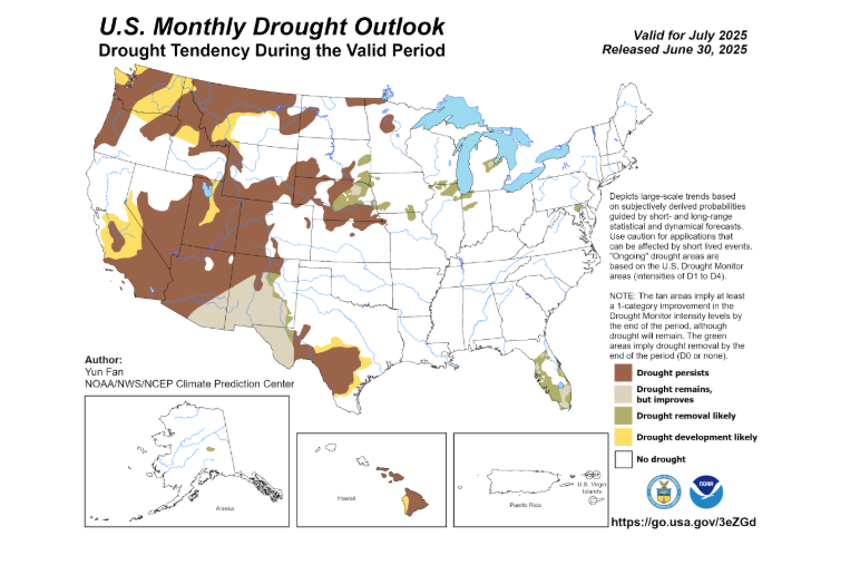
Despite the forecast for a hot July, the Climate Prediction Center (CPC) projects no new drought development through the end of the month. While “slightly increased odds of above-normal temperatures across all of Oklahoma” are expected, precipitation chances remain “equal chances of above-, near-, or below-normal.” McManus cautioned that “rapid drought development” can occur in July and August if temperatures spike without rain, potentially turning the state into a “gigantic easy bake oven.” However, the promising forecast for “a little bit more rainfall” over the upcoming weekend and early next week, coupled with increased cloud cover, is vital in preventing the formation of an intense “heat dome.”
To read more from McManus on his Mesonet Ticker, click here:


