

While no critical fire weather is expected today in Oklahoma, elevated conditions over transitional fuels will prompt a potential for increased wildfire occurrence.
Initial attack efforts are expected to remain successful for the most part, although a slight increase in large fire potential (<300 acres) is noted. The probability of significant fire occurrence remains low.
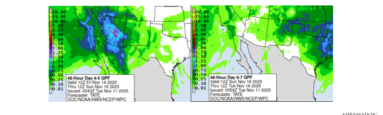
Fire weather elements will gradually relax through the week, and rain chances enter the forecast over the weekend.
📅 Today’s Forecast
Cool temperatures this morning will give way to the return of unseasonably warm conditions this afternoon, coupled with dry conditions and stronger winds.
The highest fire danger today will develop along and south of I-40 in southwestern and south-central Oklahoma. This is due to stronger southwest winds, relative humidity values <25%, and above-normal temperatures combining over transitional fuels.
Dry and breezy conditions will develop statewide, prompting expectations of a modest increase in wildfire activity. Conditions will moderate with sunset as winds relax and overnight moisture recovery is respectable.
Operational Note: OFS will have a Suppression Group prepositioned in central Oklahoma.
🗺️ Regional Breakdown
Southwest
- Temperature: 75°-81°
- Humidity: 16-23%
- Fuel Moisture: 3-4%
- Winds: Southwest sustained 9-17 mph, gusting +/-25 mph.
- Fire Behavior (Rangeland): Head fire rates of 95-155 ft/min with flame lengths 10-12 ft. (Rates nearer 175 ft/min are possible where fuels align with wind and topography).
South-Central
- Temperature: 69°-77°
- Humidity: 19-25%
- Fuel Moisture: 4-5%
- Winds: Southwest sustained 13-17 mph, gusting ~25 mph.
- Fire Behavior (Rangeland): Head fire rates 90-150 ft/min with flame lengths 9-12 ft.
- Fire Behavior (Mixed Fuels): ~60 ft/min with flame lengths 8-11 ft.
- Fire Behavior (Hardwood): ~25 ft/min with flame lengths 4-6 ft.
Panhandle/Northwest
- Temperature: Mid-70°s
- Humidity: 12-25%
- Fuel Moisture: 3-5%
- Winds: Shifting to northwest in the afternoon, sustained 6-10 mph.
- Fire Behavior (Rangeland): Fire spread potential held to < 90 ft/min.
North-Central
- Temperature: Low- to mid-70°s
- Humidity: 25-29%
- Fuel Moisture: 5%
- Winds: Southwest sustained 11-16 mph, gusting +20 mph.
- Fire Behavior (Rangeland): Head fire rates 95-150 ft/min with flame lengths 9-12 ft.
- Fire Behavior (Mixed Fuels): ~55 ft/min with flame lengths 8-10 ft.
Eastern
- Temperature: Upper-60°s
- Humidity: ~25%
- Fuel Moisture: 5-6%
- Winds: Southwest sustained 11-15 mph.
- Fire Behavior (Grass): Head fire rates 75-125 ft/min with flame lengths 9-12 ft.
- Fire Behavior (Timber): ~25 ft/min with flame lengths 4-6 ft. (Potential for some single/group tree torching in pine fuels).
🗓️ Outlook (Wednesday & Beyond)
- This Week: Dry conditions will continue, holding the potential for an uptick in initial attack activity. However, fire weather elements lack full alignment, limiting large fire potential.
- Wednesday: Temperatures remain above normal, but more gulf moisture will raise humidity and shorten the burning period. Winds will relax and shift to easterly.
- Thursday: Drier air moves into the Panhandle and western counties, but the fire environment does not raise significant concern.
- This Weekend: Optimism for some rainfall continues in the forecast.


