

To view the latest Oklahoma drought map, CLICK HERE.
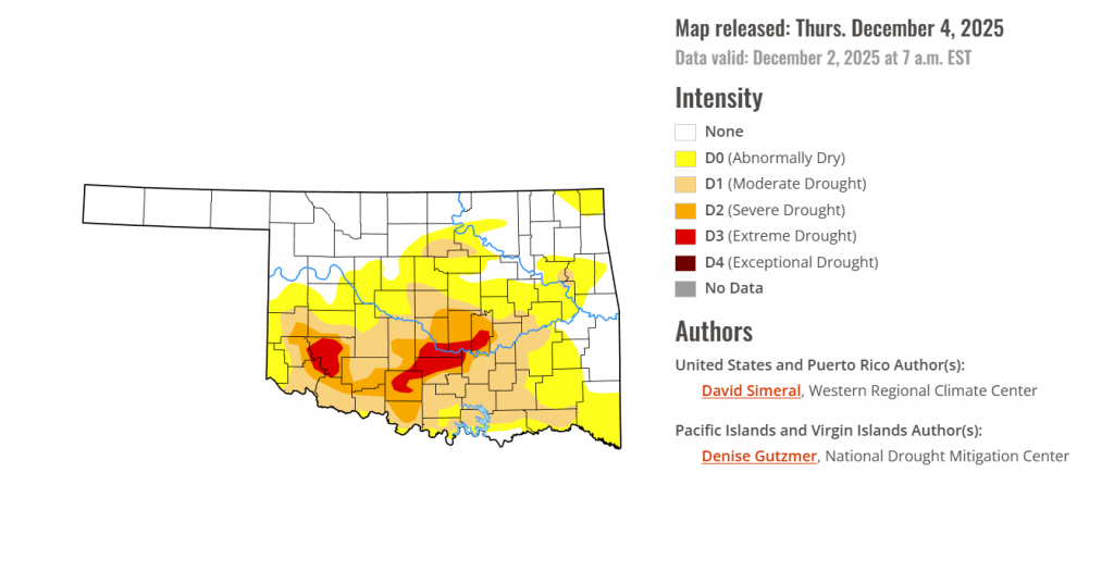
The latest Oklahoma Drought Monitor shows that while exceptional drought remains at zero percent, dry conditions are still gripping much of the state, with nearly 60% of Oklahoma affected by drought conditions ranging from abnormally dry to extreme drought. Extreme Drought (D3) continues to linger in southern counties, and outlook maps point to below-normal precipitation chances through mid-December—offering little relief in the short term.
According to the latest Oklahoma Drought Monitor report, exceptional drought remains at 0 percent, unchanged from the start of the calendar year.
D0-D4 drought conditions in the current period indicate that nearly two-thirds of Oklahoma (59.20%) is experiencing conditions ranging from Abnormally Dry (D0) to extreme Drought (D3).
Extreme Drought (D3) has remained unchanged this week. No new extreme drought has emerged, but the conditions still remain in southern Oklahoma, covering 3.48% of the state, the same as the previous week.
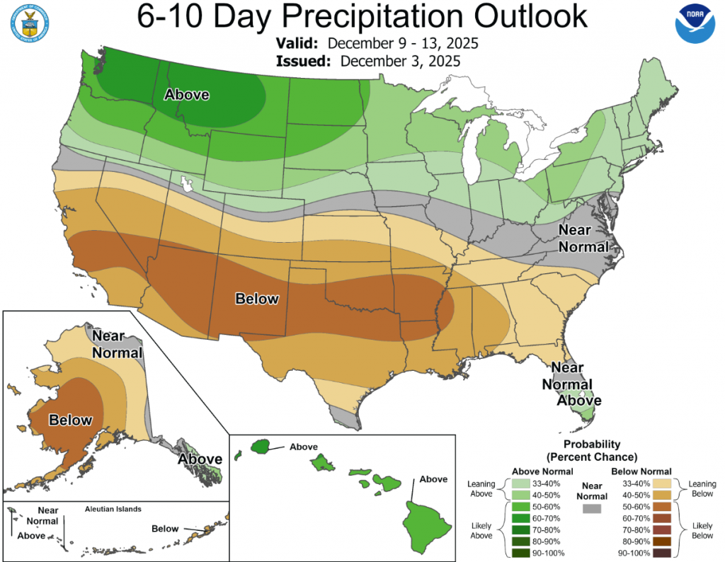
According to the 6-to-10-day precipitation outlook map, southern oklahoma is leaning below 50-60% chance of precipitation while northern oklahoma is leaning below 40-50% chance through December 13th.
This U.S. Drought Monitor (USDM) week saw improvement in drought-related conditions across areas of the West, Plains, Midwest, South, Southeast, and the Northeast. Out West, improvements continued in areas of eastern California and southern Nevada, where conditions since the beginning of the Water Year (October 1) have improved significantly. As of early December, mountain snowpack conditions continue to be well below normal levels for the time of year across much of the western U.S., except for isolated areas of the Southwest and southern Rockies, where recent storms have boosted snowpack conditions well above normal levels. As of December 2, the Natural Resources Conservation Service (NRCS) SNOw TELemetry (SNOTEL) network reported the following region-level (2-digit HUC) snow-water equivalent (SWE) levels: Pacific Northwest 43%, Missouri 47%, Upper Colorado 53%, Great Basin 39%, Lower Colorado 121%, Rio Grande 64%, and Arkansas-White-Red 53%. In California, the statewide snowpack was 39% of normal (December 3), with the Southern Sierra at 78%, Central Sierra at 36%, and Northern Sierra at 17%. Elsewhere on the map, conditions continued to improve in drought-affected areas of central and northeastern Texas, where precipitation during the past month has been above normal. In the Southeast, drought conditions have intensified in recent months, both in spatial extent and intensity, including in southern Georgia and Florida Panhandle where soil moisture and streamflow levels have dropped significantly in recent weeks. In the Northern Plains, Midwest, and Northeast, moderate-to-heavy snowfall accumulations provided some minor relief to drought-affected areas.
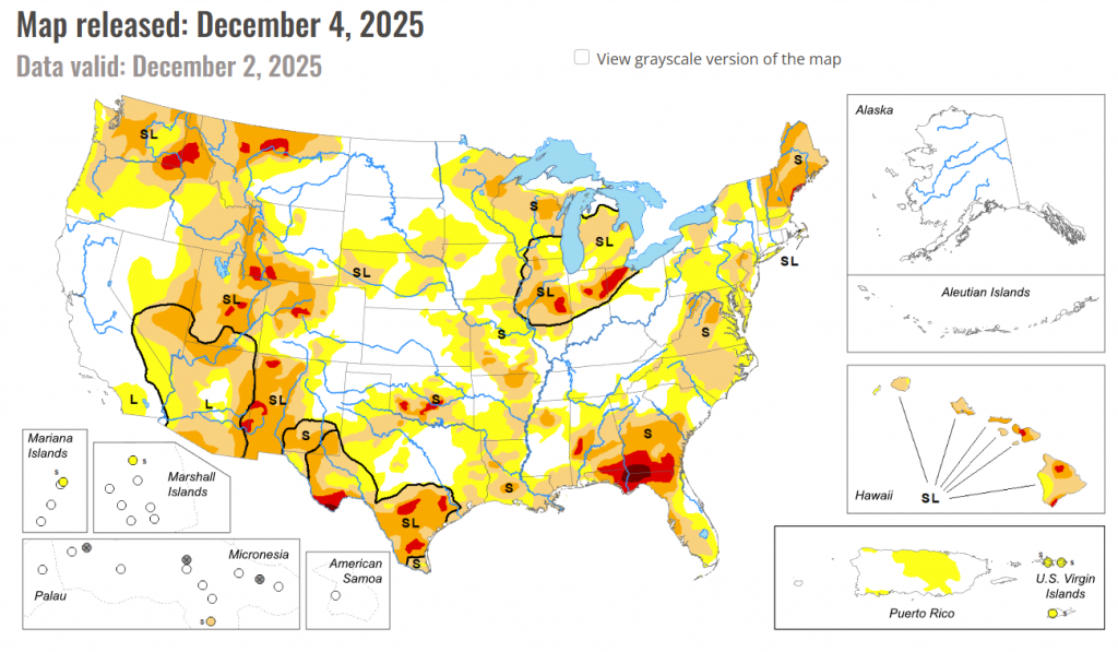
In the Southern Plains: On this week’s map, widespread improvements were made in drought-affected areas of Texas, while isolated areas of Oklahoma, Mississippi, Louisiana, and Tennessee saw minor improvements in response to rainfall activity during the past week. The heaviest rainfall accumulations were observed in isolated areas along the Gulf Coast of southeastern Texas, while lesser accumulations (ranging from 1 to 2 inches) were observed in other areas of the region including eastern and southern Texas, Louisiana, southeastern Oklahoma, southern Arkansas, northern Mississippi, and eastern Tennessee. In western Texas, conditions on the map deteriorated in response to drier-than-normal conditions during the past 90-day period. Looking at climatological rankings for the past 30-day period (November 2 to December 2), Austin, TX was 10th driest (-2.31-inch departure), College Station, TX 9th driest (-2.54 inches), New Orleans, LA 8th driest (-3.32 inches), Slidell, LA 2nd driest (-3.49 inches), and Hattiesburg, MS driest on record (-3.71 inches). In Texas, Water for Texas (December 3) reported statewide reservoirs at 74% full, with numerous reservoirs in the eastern part of the state in very good condition, while numerous reservoirs in the southern and western portion of the state were experiencing continued below-normal levels, including at Falcon Reservoir along the Rio Grande River (15.9% full). In terms of drought-related impacts, the National Drought Mitigation Center’s Conditions Monitoring Observer Reports (CMOR) tool showed numerous impact reports during the past 30-day period with the highest concentration of reports yielding from southern Oklahoma, northern Arkansas, and northern Louisiana. For the week, average temperatures were below normal across most the region with anomalies ranging from 4 to 10 degrees F above normal.
In the High Plains: On this week’s map, only minor changes were made in the region. In eastern Kansas, two areas of lingering Moderate Drought (D1) were removed in response to improving conditions during the past 90-day period. For the week, some beneficial snowfall was observed across the northern Plains, with accumulations ranging from 1 to 14 inches. The highest accumulations were logged in areas of North Dakota. In terms of average temperatures, cooler-than-normal temperatures (5 to 20+ degrees F below normal) were observed across the region, with the greatest anomalies observed in the Dakotas. According to NWS NOHRSC, the Upper Midwest region is currently 94.4% covered by snow (area) with an average depth of 3.7 inches and a maximum depth of 22.2 inches.
In the West: Out West, recent storms and overall improving conditions on short-term indicators (precipitation, soil moisture, streamflows) led to improvements on the map in California (eastern Sierra, Mojave Desert), Nevada (west-central, southern), Utah (southwestern), Wyoming (central, southwestern), Montana (northwestern, central, northeastern), and Washington (southeastern). Conversely, degradations were made on the map in areas of Oregon (central, southern), Idaho (west-central), Wyoming (southeastern), Colorado (central, north-central), and New Mexico (southeastern). For the week, most of the region experienced dry conditions except for portions of the Pacific Northwest and isolated areas in the central and northern Rockies. In the Pacific Northwest, light-to-moderate precipitation accumulations were observed along the coastal areas of northwestern Oregon and western Washington. Despite this week’s storm activity, significant precipitation deficits (2 to 10 inches since October 1) remain, with the greatest anomalies observed in the Olympic Peninsula and Cascade Range. In terms of the snowpack out West, below-normal SWE levels are being observed at SNOTEL stations across most of the West, except for areas in the southern Sierra, Colorado Plateau, and southwestern Colorado. In California, the NWS Forecast Office in Los Angeles is reporting that November was one of the wettest Novembers in the last 50+ years across southwestern California. Moreover, the city of Santa Barbara has reported the wettest water-year start on record through November with over 9.5 inches observed. Other areas in Santa Barbara County, including areas of the Santa Ynez Mountains, have received over 15 inches for the contemporaneous period.
To view the 6-10 Day Precipitation Outlook Map, click here.
To view the 6-10 Day Temperature Outlook Map, click here.
To view the Monthly Drought Outlook Map, click here.


