

To view the latest Oklahoma drought map, CLICK HERE.
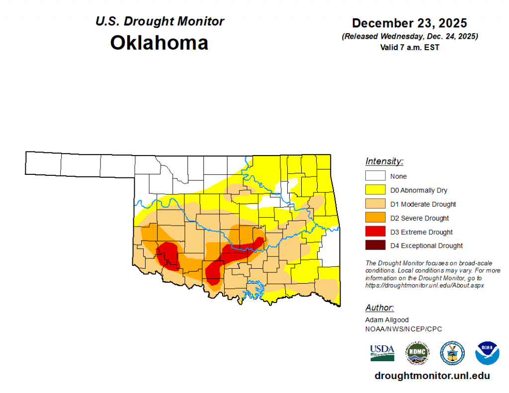
The latest Oklahoma Drought Monitor continues to show no exceptional drought in the state, but drought conditions continue to expand across the state, with close to half the state in Moderate Drought or worse. This latest Drought Monitor shows almost three fourths of Oklahoma is Abnormally dry or worse (73.70%). The yellow on the map (Abnormally Dry) shows areas that are either trending towards going into drought or may be coming of drought because of rainfall. In this case- it’s areas that are trending toward drought.
Moderate Drought (D1) has grown in the latest report from 33.58% of the state to 44.79% of Oklahoma- almost all across southern sections of the state.
Severe Drought (D2) has jumped up two percentage points to 13.13% while Extreme Drought (D3) has almost increased- up one percentage point from last week’s 3.48%.
According to the latest Oklahoma Drought Monitor report, exceptional drought remains at 0 percent, unchanged from the start of the calendar year.
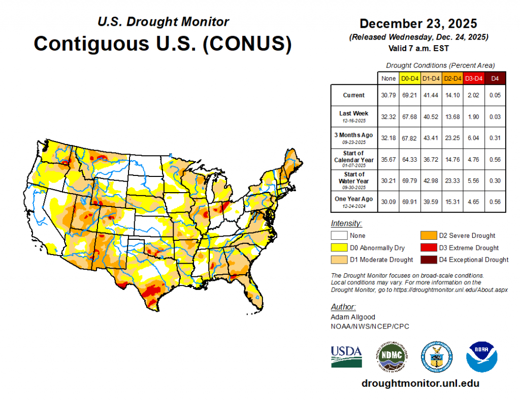
In our region (the South)– drought is growing. Following another week of subnormal precipitation, and with temperatures ranging above-normal, the South saw further drought degradations. A small area of heavier precipitation fell across far South Texas, resulting in reductions of D1 and D0, but drought expanded or intensified across the southern Texas plains, Hill Country, and the Piney Woods. Drought also intensified along the Red River Valley, and degradations were more widespread across the eastern two thirds of Oklahoma and Arkansas. In Arkansas, local observers continue to report drying lakes and ponds, while in Oklahoma, record warmth, strong winds, and persistently below-normal precipitation promoted expansion of D2 and D3 conditions. Across Tennessee, precipitation was more generous, and a swath of 1 inch or more fell across the central portion of the state where D0 conditions are currently in place. Despite this rainfall, 60- to 90-day precipitation levels remain below-normal, and SPI values continue to indicate dry conditions. Therefore, no improvements were made across Tennessee.
As for our neighbors to the north in the High Plains– A lack of snow cover, much above-normal temperatures, and periods of strong winds led to an unusual amount of winter degradation across the High Plains region.D2 expanded across western Nebraska, with expansions of both D1 and D0 occurring across central and eastern parts of the state, where precipitation was generally less than 0.2 inch equivalent, and high temperatures soared as high as the 70s. A small area of D1 expanded across southeastern Kansas, and across Colorado, D4 was introduced to Eagle and Pitkin Counties. D0 expanded across the Plains of Wyoming, where warm temperatures, strong winds, and a record lack of snow cover promoted worsening impacts. Drought depictions remained unchanged across the Dakotas, where soils and streams have largely frozen for the winter.
Looking ahead-During the next few days, atmospheric river activity will continue to bring copious moisture to the West, with the focus of heavy coastal rainfall and mountain snows shifting to California. Heavy precipitation is forecast to push inland to the Great Basin and portions of the Rockies. Later in the week, as the Pacific trough moves onshore and ridging builds over the northeastern Pacific, a break in AR activity is favored through the end of Week-1. Further east, persistent ridging is forecast for the central US, leading to mostly dry conditions and much above-normal temperatures for the Plains. Across the East, a blocking ridge retrograding towards Greenland from Europe will promote backdoor front activity and cold air damming, as well as providing a focus for additional precipitation and winter storm activity. The WPC 7-day QPF forecast shows precipitation amounts exceeding an inch across most of the Northeast Region, much of which may fall as snow or a wintery mix across the mid-Atlantic. Mostly dry conditions are favored for the Southeast during Week-1, with light rain possible across the lower Mississippi Valley. During Week-2, CPC forecast indicate enhanced chances for above-normal precipitation for the western third of the CONUS, with the highest probabilities across the Southwest. A slight tilt towards above-normal precipitation extends along the northern tier to the Great Lakes region, while below-average precipitation is favored for much of the eastern seaboard. Strong anomalous ridging favors above-normal temperatures for most of the CONUS, with blocking potentially leading to below-average temperatures across the Northeast. Above-normal precipitation is favored for Hawaii, while below-normal temperatures are favored for Alaska, with drier than normal conditions expected along the southern tier of the state.
To explore details of current drought conditions, check individual states and look at the outlook that’s ahead- click here.


