

To view the latest Oklahoma drought map, CLICK HERE.
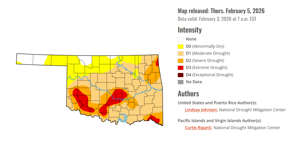
Oklahoma continues to grapple with expanding drought conditions, with nearly three-quarters of the state now classified from moderate to extreme drought, even as exceptional drought remains absent. Much of the snow that fell during recent winter weather has now melted, and temperatures are beginning to edge slightly higher. With another largely dry week behind the state, short-term moisture deficits continue to grow, keeping drought concerns front and center as February progresses.
According to the latest Oklahoma Drought Monitor report, exceptional drought remains at 0 percent, unchanged from the start of the calendar year.
Moderate drought to extreme drought conditions in the current period indicate that 73.57% of the state is affected by drought. Compared with last week’s 71.69%, drought conditions have this week.
Extreme Drought has also grown this week, now covering 9.21% of the state in southwestern Oklahoma, affecting mainly Pottawatomie, Seminole, McClain, Garvin, Stephens, Kiowa, Washita, and parts of surrounding counties.
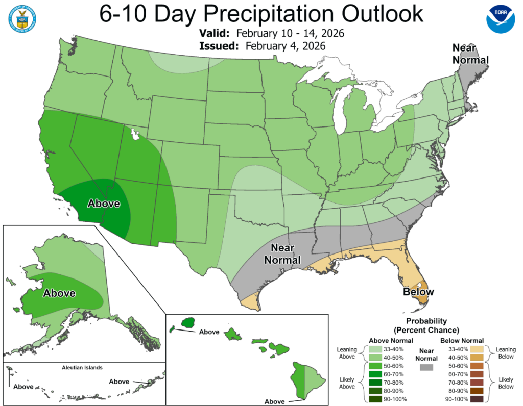
According to the 6-to-10-day precipitation outlook map, Oklahoma’s panhandle is leaning above 40-50% chance of precipitation through February 14th, while the rest of the state is leaning above 33-40% chance through that same date.
There was a strong west-to-east temperature gradient this week, with temperatures below normal in the East, particularly in the Midwest and Northeast, and above normal in the West. Precipitation was scarce across large portions of the nation, with many areas receiving less than 25% of normal precipitation. Areas of localized precipitation fell across the Pacific Northwest, northern Rockies and the Great Lakes region. Out east, a winter storm brought snow and mixed precipitation to parts of the Tennessee Valley and the Carolinas, with locally heavy snowfall in some locations. Across the West, snowpack remains well below the seasonal average. Even in areas that received snow, low snowpack combined with dry soils and low streamflows led to degradations across the Intermountain West. Along the West Coast, precipitation remained limited and uneven. Western Oregon saw dry and drought conditions expand toward the Pacific coast and into far south Washington and northwest California. Elsewhere, scattered degradations occurred across the South and Southeast, where another week without precipitation added to growing precipitation deficits, except for localized areas of improvement that continued to benefit from last week’s heavy snowfall. Other isolated areas of improvement were seen in southern New Mexico and in the Midwest and Northeast.
In the Southern Plains: Drought conditions across the South generally continued to worsen this week, as much of the region received little to no precipitation. Temperatures were near to slightly above normal across large portions of the region. Outside of a few localized improvements in northeast Louisiana and southeast Mississippi from last week’s winter storm, conditions continued to degrade across most of the region. Across the southern Plains into the Lower Mississippi Valley, one-category degradations were seen across parts of Texas, Oklahoma, Arkansas, Louisiana and southwest Mississippi after another dry week with no meaningful precipitation. Short- to mid-term precipitation deficits continue to grow and soil moisture continues to decline, along with streamflows.
In the High Plains: Conditions across the central and northern High Plains were mostly unchanged this week, as most of the region received little to no meaningful precipitation. Cold temperatures persisted, and where snow did fall, it remained largely frozen in place, limiting short-term benefits to soils or hydrologic conditions. Conditions across the Wyoming and Colorado Plains continued to deteriorate. Snow water equivalent (SWE) remains well below average, with SNOTEL data showing values generally in the 50 to 70 percent of median range, reflecting how snowpack continues to fall short for this time of year despite recent snowfall. Severe drought (D2) expanded from southeastern Wyoming into northeastern Colorado and a little into the Nebraska Panhandle. Abnormal dryness (D0) and moderate drought (D2) also expanded across portions of Kansas.
In the West: Across much of the West, conditions worsened, driven by a deepening snow drought, limited precipitation, and above-normal temperatures that continued to undermine snowpack development. While some mountain snowfall occurred, amounts were generally modest and failed to keep pace with early February climatological accumulation rates, causing snowpack deficits to expand across much of the region. The Intermountain West saw conditions intensified as snow accumulation continues to fall well short of what is expected this time of the year. Numerous SNOTEL sites reported SWE below the 15th percentile, with several stations registering the lowest SWE on record for early February. These snowpack deficits were compounded by limited recent precipitation, declining soil moisture, and below-normal streamflows, particularly across northern Idaho and western Montana and extending into central and southern Montana and Wyoming. Similarly, Colorado and Utah saw conditions deteriorate as SWE levels are well below the median level along with drier soil moisture. Across southwestern Idaho, northern Nevada and into eastern Oregon, persistent warmth, scarce precipitation, poor low-elevation snowpack, and low streamflows led to the expansion of abnormally dry (D0) and moderate drought (D1) conditions as well as the introduction of moderate drought (D2) along the Idaho-Wyoming border. SNOTEL stations in the Owyhee, Independence and Snake Mountains are reporting SWE levels between the ninth percentile to the worst on record.
To view the 6-10 Day Precipitation Outlook Map, click here.
To view the 6-10 Day Temperature Outlook Map, click here.
To view the Monthly Drought Outlook Map, click here.


