

A period of moderated fire weather over the weekend has allowed Oklahoma Forestry Services (OFS) and local fire departments to make significant progress on several large wildfires. While the calmer conditions have enabled some resources to be released for future assignments, officials warn that dry conditions and rising “Energy Release Components” (ERC) indicate a persistent and growing resistance to control.
Current Large Fire Status
Firefighting crews continue to manage several significant incidents across the state and into neighboring Kansas. Containment percentages have risen steadily, though thousands of acres remain active.
| Incident Name | Location | Estimated Acreage | Containment |
| Ranger Road Fire | Beaver/Harper Co. / KS | 283,283 | 65% |
| Stevens Fire | Texas Co. / KS | 12,428 | 90% |
| Poor Farm Fire | Latimer County | 9,565 | 90% |
| Drowning Creek Fire | Delaware County | 536 | 90% |
| 615 Fire | Cherokee County | 242 | 90% |
| Backwoods Hunting Club | Adair County | 114.5 | 80% |
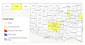
In the Southeast Area, four new fires were reported over the weekend totaling 33.7 acres. Investigations into these starts identified one as an escaped control burn and three as incendiary in nature.
Regional Outlook and Fire Behavior
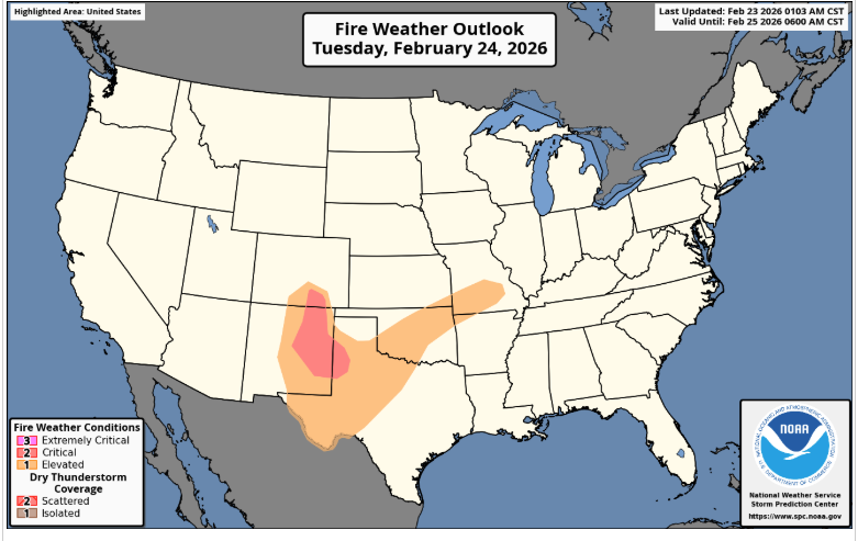
Despite the recent progress, fire danger remains a primary concern as relative humidity values are expected to dip below 25% statewide this afternoon.
Western Oklahoma and the Panhandle
The highest risk resides in the western regions. Temperatures in the 60s combined with humidity as low as 11% have dropped fine-dead fuel moisture to roughly 4-5%.
- Rangeland: Expect head fire rates of spread between 160–230 ft/min with flame lengths up to 14 feet.
- Mixed Fuels: Fire behavior may include torching and short-range spotting, with flame lengths reaching 21 feet.
Central and Eastern Oklahoma
While wind speeds remain lower in the east (2–8 mph), fuel dryness is still a factor. In the South-Central and Southeast regions, observations show degrading composite fuel moisture. While initial attacks are expected to be successful today due to light winds, the resistance to control is trending upward.
The Week Ahead: Increasing Probabilities
The state is entering a period of recurrent fire danger. A cold front is expected to move through on Wednesday, bringing a slight chance of rain to northern Oklahoma. However, the dry environment following the front will likely maintain elevated risks.
Tuesday Forecast:
A low-level thermal ridge will develop, pushing temperatures above normal. Single-digit humidity in the Panhandle and breezy southwest winds will challenge initial attack efforts, particularly in western, central, and northern counties. While the overall potential for a “significant” breakout remains low, the probability of “large” fire growth is increasing due to the combined fuel loading and wind speeds.
Resource Mobilization
OFS has pre-positioned suppression groups, including engines, dozers, and overhead personnel, in the following strategic locations to ensure rapid response:
- Guymon
- Woodward
- Weatherford
- Lawton
- Shawnee
Residents are encouraged to remain vigilant, as overnight moisture recovery is expected to be poor, preventing the typical “reset” of fuel moisture levels during the evening hours.


