

To view the latest Oklahoma drought map, CLICK HERE.
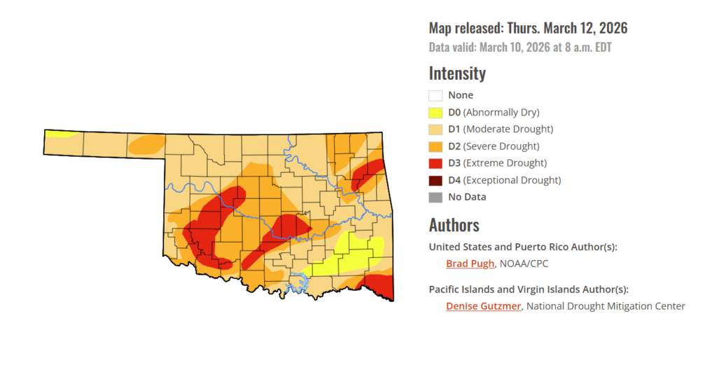
Drought continues to hold a tight grip on Oklahoma this week. Part of southeastern Oklahoma has been downgraded from moderate drought to abnormally dry conditions, but areas of extreme drought continue to spread across the areas they’ve been affecting for weeks.
According to the latest Oklahoma Drought Monitor report, exceptional drought remains at 0 percent, unchanged from the start of the calendar year.
Moderate drought to extreme drought conditions in the current period indicate that 93.97% of the state is affected by drought. Compared with last week’s 99.43%, drought conditions have shrunk by 5.46 %.
Extreme Drought conditions have spread this week, now covering 13.24% of the state, up from 12.97% last week, affecting mainly Blaine, Tillman, Pottawatomie, Seminole, McClain, Garvin, Stephens, Kiowa, Washita, Delaware, Ottawa, Mayes, Cherokee, McCurtain, and parts of surrounding counties.
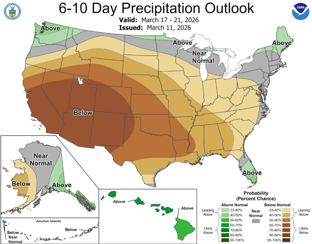
According to the 6-to-10-day precipitation outlook map, the majority of oklahoma is leaning below 50-60% chance of rain and the westernmost tip of the state is leaning below 60-70% chance of precipitation.
Following a drier-than-normal winter, a pattern change at the beginning of March resulted in widespread heavy precipitation (1 to 3 inches, locally more) and a 1-category improvement to parts of the Ohio and Middle to Lower Mississippi Valley. This drought improvement extended east to the Central Appalachians and the Northeast. However, a long-term drought continues for much of the Northeast. Despite the much-needed rainfall for portions of the Southeast and Southern Great Plains, severe (D2) to extreme (D3) drought persists for many areas. A low snowpack and early onset of snowmelt are a major drought concern for the West. As of March 10, drought of varying intensity was designated for parts of Hawaii. Alaska and Puerto Rico remain drought-free.
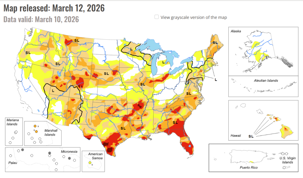
In The South: Despite the locally heavy rainfall across the Lower Mississippi Valley along with eastern Oklahoma and Texas, only modest improvements were warranted as a favorable response among the various indicators was not enough to justify more widespread 1-week changes. However, targeted 1-category improvements were made to parts of northwestern Arkansas, eastern Oklahoma, eastern Texas, and the Lower Mississippi Valley where weekly precipitation amounts exceeded 2 inches. In areas that missed out on the beneficial rainfall, drought intensified for parts of west-central Oklahoma and the Oklahoma Panhandle. A majority of the South Region has received less than half their normal precipitation with a temperature departure of more than 6 degrees F above normal during the past 90 days. These 3-month precipitation and temperature observations are consistent with a La Nina wintertime pattern.
In the High Plains: Widespread drought of varying intensity continues across much of the Central Great Plains and Central Rockies. Drought expanded this past week to include all of southwestern Colorado and intensified for northwestern parts of the state. The low snowpack throughout the Central Rockies, especially Colorado, remains a major concern heading into the spring. As of March 10, snow water equivalent for the river basins of Colorado is running below 70 percent of the 1991-2020 average. There were a couple exceptions to the worsening conditions. A wet snow (1” or more, liquid equivalent) supported the removal of extreme (D3) drought across parts of the Denver metro area. Heavy rainfall (more than 1.5 inches) prompted small 1-category improvements to eastern Kansas and southeastern Nebraska.
In the West: The low snowpack throughout much of the West is a major concern heading into the spring. As of March 10, snow water equivalent (SWE) is less than 40 percent of normal from the Cascades of the Pacific Northwest southward through the Great Basin and Four Corners region. 14-day temperatures, valid from February 25 to March 10, have averaged 5 to degrees F above normal. This warmer-than-normal end to February and start to March has led to an early onset of snowmelt for parts of the West. Although California remains drought-free, SWE is 53 percent of normal statewide according to the California Department of Water Resources. Overall, only minor changes were made this past week to the West Region. Based on increasing 60-day precipitation deficits and to reflect the low snowpack, abnormal dryness (D0) was added to parts of northern California. Drought expanded into southeastern Utah while intensifying to severe (D2) and extreme (D3) drought across northeastern and western portions of the state. Moderate (D1) drought was expanded across north-central to northeastern Washington along with central Oregon due to 30 to 90-day precipitation deficits and low snowpack.
To view the 6-10 Day Precipitation Outlook Map, click here.
To view the 6-10 Day Temperature Outlook Map, click here.
To view the Monthly Drought Outlook Map, click here.


