

Oklahoma is currently enduring a stretch of volatile weather characterized by near-record temperatures, high winds, and a mounting drought, according to State Climatologist Gary McManus, but hope may be on the way. The state experienced lots of fire risk with a “dirty, hazy day” yesterday, fueled by smoke and dust, with a similar pattern expected to continue today.
Historic Heat and Fire Danger
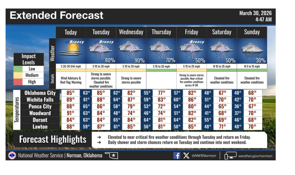
The heat has reached historic levels for the month of March. Last Thursday, the Oklahoma Mesonet site in Beaver recorded a temperature of 106 degrees, officially breaking the record for the highest temperature ever recorded in Oklahoma during the month of March.
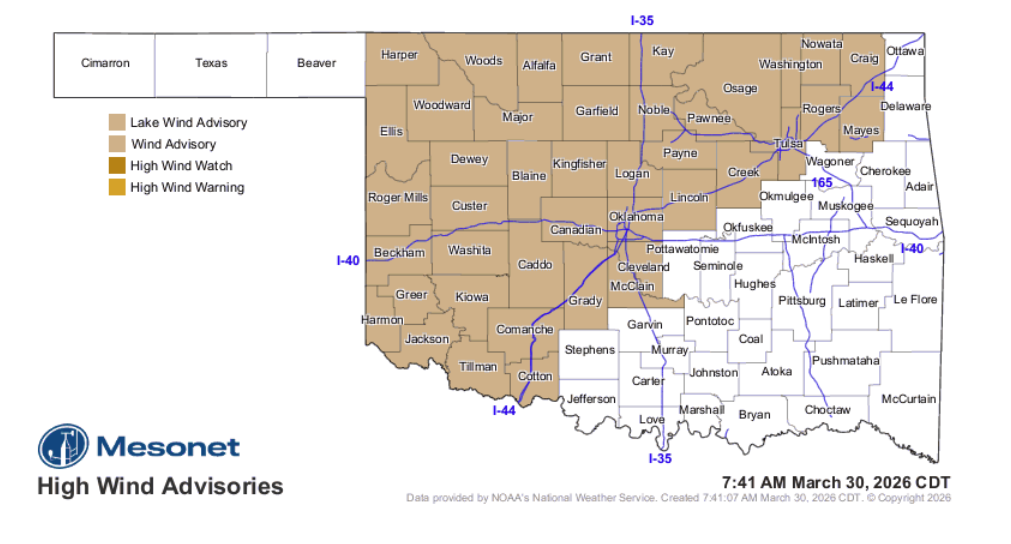
These high temperatures are being accompanied by intense wind gusts reaching near 50 mph. The combination of heat, low humidity, and high winds has created a dangerous environment for wildfires.
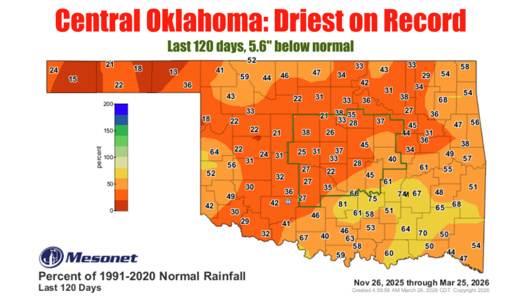
Record Dryness in Central Oklahoma
While the Panhandle is seeing record-breaking heat, central Oklahoma is grappling with an extreme lack of moisture. The region is currently experiencing its driest period on record since approximately Thanksgiving. This persistent lack of rainfall has heightened concerns about the long-term impact of the current drought cycle.
Critical Timing for Winter Wheat
For Oklahoma wheat farmers, this potential shift in the weather is a “make-or-break” moment. The crop is currently transitioning from jointing to flowering—a critical reproductive stage—where moisture is essential for grain formation. Experts note that the current combination of 90-degree heat and high winds is rapidly depleting subsoil moisture, which can lead to “sterile heads” and smaller seed sizes. A significant rain event now would not only provide the water necessary for yield potential but could also naturally suppress growing populations of brown wheat mites that thrive in these dry, dusty conditions
Potential Relief on the Horizon
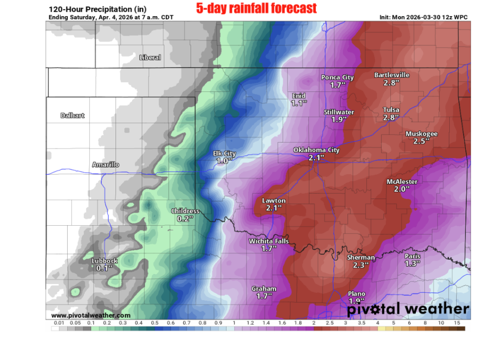
Despite the current conditions, there is a glimmer of “hopeful optimism” in the forecast. A shifting weather pattern may bring several days of rain chances to the state, along with the possibility of severe storms, beginning Tuesday and extending into the weekend.
However, McManus notes that these storm systems are currently situated over the Pacific Ocean, making the exact timing and accumulation totals difficult to guarantee. Previous forecasts for a wet March have largely failed to materialize, and as the climatologist points out, it historically “tends to NOT rain during droughts.”
The upcoming week will be a critical period for Oklahoma as residents wait to see if the “worm will turn” and provide the much-needed moisture to offset the burgeoning drought and high fire danger.
To read more from Gary McManus on his mesonet ticker, click here:


