

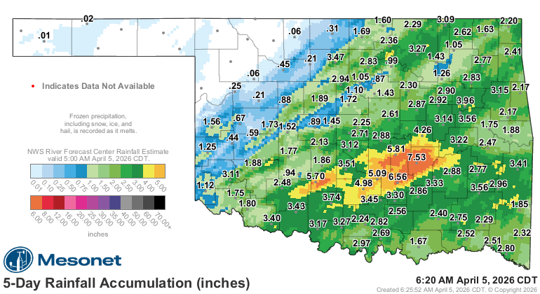
A double shot of rainfall since the start of the month resulted in the southeastern half of the state seeing lots of two inch rainfall totals the first four days of April. According to Oklahoma Mesonet data, Pontotoc and Hughes Counties in east central Oklahoma had the highest rainfall totals from the early April rains- with Holdenville reporting 7.53 inches and Ada coming in with 6.56 inches of rainfall. Both of those counties are just to the east of the D3 Extreme Drought reported on Thursday, April 2nd.
Many locations in the D3 Extreme drought of southwest to central Oklahoma did receive over two inches of rain. Grandfield and Walters both topped three inches of rainfall in these latest set of storms. It remains to be seen how much drought reduction might come in the driest parts of Oklahoma in the next Drought Monitor which will be released Thursday morning, April 9th. Check out the latest Drought Monitor map for Oklahoma- available here.
Northwestern Oklahoma was left out of the rain events, which might mean drought intensification will happen in those areas of the state in the next report. Already, most of Beaver County in the Panhandle is in extreme drought. Much of the rest of northwest Oklahoma is in severe drought (D2).
Oklahoma has already seen active weather in the first few days of April 2026, with several rounds of thunderstorms, heavy rain, and flooding threats:
Forecasts for the coming days (as of April 5) include additional rain chances, particularly mid-to-late week, with potential for severe storms, heavy downpours, and localized flooding in eastern/southeastern Oklahoma. The pattern remains active with Gulf moisture and storm systems, which is typical for April in Tornado Alley but appears amplified in the short term.
What to Expect for the Rest of April
- Long-range models and almanacs suggest a potentially wetter-than-average April in many areas, especially with the active severe weather season. However, rainfall in Oklahoma is often “feast or famine” due to convective storms—some spots may flood while others stay relatively dry.
- Watch for ongoing thunderstorm risks, which can produce localized heavy rain (2–4+ inches in a single event) alongside hail, winds, and tornadoes.
At the recent Texas and Southwestern Cattle Raisers Convention, Senior Farm and Ranch Broadcaster Ron Hays talked with atmospheric scientist Matt Makens about the expected move from La Nina to El Nino here in 2026- click here for conversation with Makens.


