

To view the latest Oklahoma drought map, CLICK HERE.
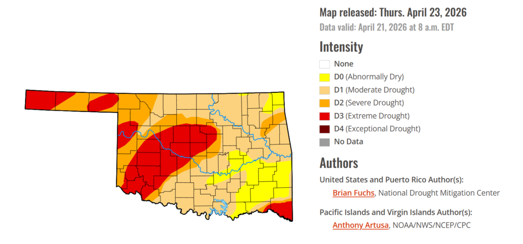
Oklahoma saw a slight improvement in drought conditions this week, with statewide drought numbers edging lower compared to last week. Southeastern Oklahoma continues to see conditions improve as drought classifications subside, offering some relief in an area that has dealt with persistent dryness. Even with that progress, producers across the state are still counting on timely rainfall in the weeks ahead to help stabilize pasture conditions and give the struggling wheat crop a much-needed boost.
According to the latest Oklahoma Drought Monitor report, exceptional drought remains at 0 percent, unchanged from the start of the calendar year.
Moderate to extreme drought conditions in the current period indicate that 85.74% of the state is affected by drought, down 13 points from last week. Southeastern Oklahoma is seeing drought conditions ease, with areas shifting into the lower drought tier of abnormally dry conditions.
Extreme Drought conditions have decreased this week by .41%, covering 25.84% of the state, affecting mainly Blaine, Tillman, Pottawatomie, Seminole, McClain, Garvin, Stephens, Kiowa, Washita, Delaware, Ottawa, Mayes, Cherokee, McCurtain, Oklahoma, Canadian, Kingfisher, Cimmaron, Beaver, and parts of surrounding counties.
According to the 6-to-10-day precipitation outlook map, most of Oklahoma is leaning above a 33-40% chance of precipitation through May 2nd, while southeastern Oklahoma is leaning above 40-50% through the same date.

The week was highlighted by a band of above-normal precipitation extending from south Texas into eastern Oklahoma, Missouri, Illinois, Michigan, and southern Wisconsin. Many areas in this swath received greater than 150% of normal precipitation, with some locations exceeding 400% for the week. From the Ohio Valley south into the Southeast, conditions remained quite dry, with little to no precipitation recorded across most of the region. The West was also largely dry, with only coastal areas of California and parts of the Pacific Northwest recording above-normal precipitation. Northern portions of the Northeast received rain, with areas from western New York into Maine recording 200% or more of normal precipitation. Temperatures were near normal to slightly below normal across the West, with departures of up to 5°F below normal in some areas. Portions of the central Plains, Midwest, Northeast, and Mid-Atlantic experienced above-normal temperatures, with departures of 5–10°F above normal. Temperatures in the Southeast were near to slightly above normal, with cooler conditions in the Florida Panhandle.
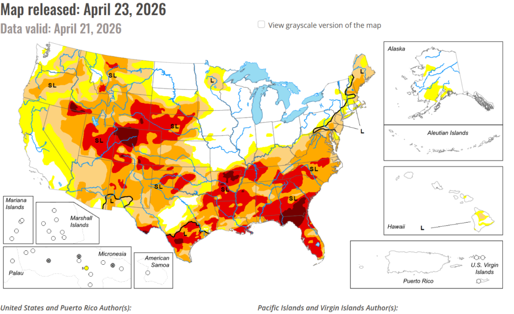
In the South: Temperatures were above normal across northern and eastern areas, with departures of 2–6°F. Across Texas, temperatures transitioned to below normal in southern and western areas, with departures of 2–6°F below normal. The heaviest rainfall occurred from central to southern Texas into central and eastern Oklahoma, where totals reached 150–400% of normal. Elsewhere, conditions were mostly dry, including the Texas and Oklahoma Panhandles, and much of Arkansas, Louisiana, Mississippi, and Tennessee. Where rainfall was sufficient in Texas and Oklahoma, drought conditions improved or were removed. However, drought intensified across Mississippi, where nearly the entire state experienced a full category of degradation and is now 100% in drought. Extreme drought expanded in eastern Arkansas and northern and southern Louisiana, with moderate drought increasing in southern Louisiana. Severe and extreme drought expanded across western Tennessee, while moderate drought increased in the east. Tennessee is now also fully in drought.
In the high Plains: The region was mostly dry, with isolated rainfall in far southeast Nebraska, northern and southeast Kansas, and small areas of Colorado and North Dakota. Temperatures were generally above normal, with the warmest departures in southeast Nebraska and eastern Kansas. Dryness and a warm spring led to widespread degradation. Extreme drought expanded across central and western Nebraska and into northwest Kansas. Severe drought expanded in central and southwest Kansas, with new extreme drought in far southwest Kansas. Degradation continued across the plains of Wyoming and Colorado, with expansion of moderate to extreme drought. Extreme drought was also introduced in southern South Dakota. Some improvements occurred in southeast Kansas, where moderate drought and abnormally dry conditions were reduced due to recent rainfall.
In the West: Precipitation was mixed. Parts of central to northern California, western Oregon and Washington, much of Idaho, and isolated areas in Montana, Utah, and Colorado recorded above-normal precipitation. However, most of the region remained drier than normal. Temperatures were generally cooler than normal, with northern Nevada experiencing departures of up to 6°F below normal. Southern California and Arizona saw the warmest conditions, with temperatures up to 6°F above normal. Drought conditions worsened across much of Nevada, with expansion of abnormal dryness to severe drought. Severe drought expanded into northwest Utah, while moderate to severe drought increased in western and southern Arizona. Severe drought also expanded in western Wyoming, and extreme drought was introduced in southwestern Montana. Oregon and Washington saw slight expansion of abnormally dry to moderate drought, with a small increase in severe drought in southwest Oregon. Southern California also experienced expansion of abnormally dry conditions. Impacts are becoming more evident as snowpack has largely melted, and early runoff may contribute to future water supply issues.


