

To view the latest Oklahoma drought map, CLICK HERE.
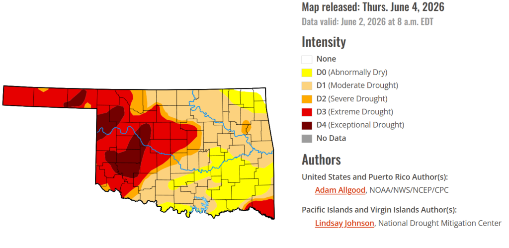
Oklahoma’s drought picture continues to tell two different stories depending on where you are in the state. While repeated rounds of spring rainfall have brought significant relief to many areas east of I-35, conditions across western Oklahoma continue to deteriorate as persistent dryness, high temperatures, and mounting moisture deficits take a toll on pastures, crops, and water supplies. As summer approaches, drought concerns remain firmly centered on the western half of the state, where some producers are already facing impacts typically associated with long-term drought.
According to the latest Drought Monitor, exceptional drought persists in parts of western Oklahoma, including Kiowa County, Ellis County, Beaver County, Woodward County, and surrounding areas. Historic impacts of exceptional drought include rising hay and water costs, limited supplies, and herd liquidation by producers. Ranchers and farmers are facing severe economic losses as failed crops are baled or abandoned, pastures turn bare, and cracked, dry land leaves some fields unusable. Exceptional drought currently covers 9.21% of the state compared to just 4.35% last week.
Moderate to extreme drought conditions in the current period indicate that 80.76% of the state is affected. At this point, only 0.69% of the state remains drought-free in far northeastern Oklahoma.
The trend of easing drought conditions in eastern Oklahoma and worsening conditions in western Oklahoma continues, with I-35 generally serving as the dividing line between the two.
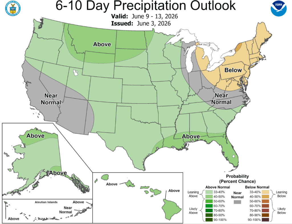
According to the 6-to-10-day precipitation outlook map, all of Oklahoma is leaning above a 33-40% chance of precipitation through June 13th.
The mid-level height anomaly pattern during the week exhibited an omega-block type pattern, with mean troughing over Alaska and both the West and East, with the western trough cutting off over California, and strong ridging between the troughs across the central contiguous US. This pattern promoted below-normal temperatures across the Southwest for much of the period, with colder air pushing eastward towards the end of the week followed by warming temperatures. Across the East, cooler air overspread New England and the mid-Atlantic, keeping evapotranspiration rates a bit lower than normal. In contrast, much above-normal temperatures were observed throughout the week across the northern Plains and upper-Midwest, though colder weather and storminess overspread the northern Rockies and adjacent High Plains at the end of the week. An active pattern was noted across the Plains, South, and Southeast as a mean frontal boundary provided a focus for stormy weather. These rains, in conjunction with a wetter pattern overall during May, prompted widespread additional drought relief for the South and Southeast regions, as well as portions of the High Plains. In contrast, hot, dry weather across the northern Plains and upper-Midwest caused expansion of drought and abnormal dryness, with widespread degradation occurring in western portions of the Midwest region. Towards the end of the week, a storm system brought heavy precipitation to western and central Montana, bringing some drought relief following a period of hot, windy weather. Across the Northeast, additional rainfall benefitted portions of New England, while drier weather overspread the mid-Atlantic and southern New England following a wet week previously.
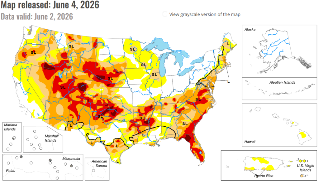
In the South: Soaking rains overspread most of Texas during the week, promoting additional drought reductions, primarily across southern Texas and the Big Bend country. Rainfall also overspread eastern Oklahoma, but conditions worsened across the western half of the state which fared drier during the week. Along the lower Mississippi Valley, heavy rains, exceeding 6 inches in some locations, fell across northern Arkansas, promoting drought reduction. Soaking rains were less intense across Louisiana and Mississippi, but were still sufficient to promote substantial drought reduction at the tail end of a wet May. Although conditions have improved overall across the Southern Region, widespread D3 to D4 continues across northern Texas and western Oklahoma, and long term drought impacts to groundwater remain a concern heading into the summer months across the whole region.
In the High Plains: Stormy weather brought soaking rains across much of the High Plains, with the highest coverage and accumulations over Kansas and Nebraska. While beneficial, this precipitation competed during the week with much above-normal temperatures, which maintained high evapotranspirative demands. Accordingly, areas that missed out on significant rainfall, including portions of the Dakotas and far northern Nebraska, experienced some degradation, while reductions were noted across much of Kansas and eastern Nebraska. Further west, beneficial precipitation brought some relief to portions of the Colorado Plains and a few spots in Wyoming, while drier conditions resulted in deterioration in southwestern Colorado.
In the West: A late season storm system brought heavy rainfall to southern Oregon and northern California, sparking a few modest improvements but overall doing little to change the current drought depiction. Some degradations were noted across portions of California, Oregon, and the Great Basin, where impacts from a lack of snowmelt recharge – especially low streamflows – are beginning to be felt. Temperatures during the week were near to above-average across the Northwest, but below average across California, helping to keep evapotranspiration demands lower than average.
To view the 6-10 Day Precipitation Outlook Map, click here.
To view the 6-10 Day Temperature Outlook Map, click here.
To view the Monthly Drought Outlook Map, click here.


