

An extraordinary month of severe weather and rainfall has left Oklahoma with historic wind records and complex agricultural conditions, according to State Climatologist Gary McManus. While June 2026 did not feature headline-grabbing tornado outbreaks, it delivered unprecedented straight-line winds alongside a substantial rainfall rebound that brought significant yet uneven drought relief to the state.
Unprecedented Straight-Line Winds Dominate Severe Weather
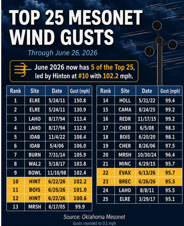
Straight-line winds took center stage during June, establishing a remarkable milestone for the state. The Oklahoma Mesonet recorded six of its top 50 all-time wind gusts during the single month, a feat unmatched since the network was commissioned in January 1994.
The most widespread destruction developed between June 21 and 22, when a powerful derecho tracked from northwest to southeast across the state. This expansive system generated two triple-digit wind gusts at the Hinton Mesonet site, peaking at 102 mph and 101 mph. The Hinton gusts ranked as the 10th and 12th strongest ever measured by the network.
During this single derecho event, the Mesonet registered 54 severe wind gusts of at least 58 mph, including 20 gusts reaching at least 70 mph and eight hitting 80 mph or higher. The resulting winds uprooted trees, downed power lines, damaged homes and agricultural structures, left tens of thousands of residents without power, and caused a BNSF train derailment near Woodward that blocked both main tracks. The damage path eventually spanned from the Kansas High Plains all the way to southwestern Arkansas.
The month’s extreme wind profile extended beyond the derecho. On June 25, a severe storm in the Oklahoma Panhandle brought a 101 mph gust to Boise City, ranking 11th on the all-time list. Earlier in the month, Eva recorded a 96 mph gust on June 13, while Breckinridge matched that 96 mph mark on June 26. Additionally, an 89 mph gust at Freedom during the June 22 derecho ranked 50th all-time. To put these numbers in perspective, the state’s all-time record remains the 151 mph gust recorded at El Reno during an EF5 tornado on May 24, 2011.
Rainfall Rebound Cuts Widespread Drought
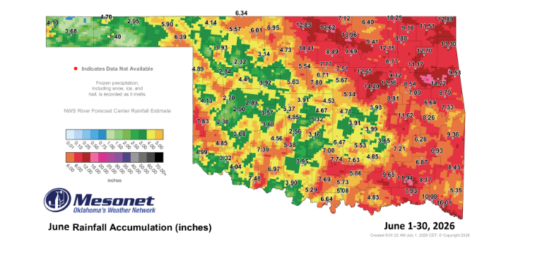
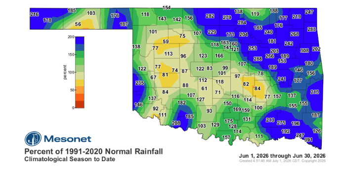
Oklahoma experienced a major moisture turnaround in June, finishing as the 16th-wettest June since historical records began in 1895. The statewide average precipitation reached 6.68 inches, which is 2.42 inches above normal.
Rainfall accumulation varied dramatically across the state, with Idabel recording a state high of 16.01 inches and Goodwell recording a low of 1.40 inches. Out of the 120 Mesonet monitoring sites, 78 recorded at least 5 inches of rain, 62 saw at least 6 inches, 35 reached 8 inches or more, and 19 sites topped the 10-inch mark. More than 40 locations finished at least 2 inches above their June average, with Idabel securing an impressive 11.9-inch surplus.
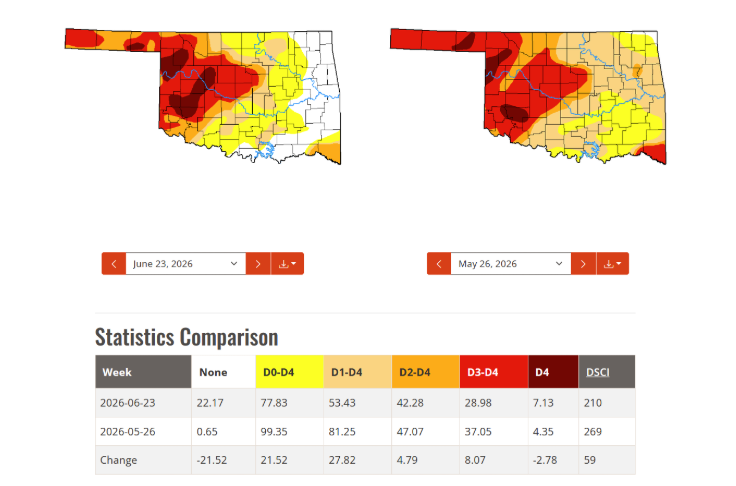
This influx of moisture triggered substantial drought recovery across the eastern two-thirds of the state. According to data from the U.S. Drought Monitor, overall drought coverage dropped from 81% of Oklahoma on May 26 to 53% by June 23. Severe-to-exceptional drought fell from 47% to 42%, while extreme-to-exceptional conditions dropped from 37% to 29%.
However, the moisture distribution remained highly unequal. A focused area of rain deficits, ranging from a half-inch to over an inch below normal, stretched from west-central into southwestern Oklahoma and just south of the Oklahoma City metro area. Because western regions missed out on the heaviest downpours, exceptional drought actually expanded from 4% to 7% of the state, with the worst remaining conditions concentrated from west-central Oklahoma into the Panhandle.
June by the Numbers
- Statewide Average Temperature: 79.1°F (1.8°F above normal, ranking as the 27th-warmest June since 1895)
- Temperature Extremes: High of 107°F at Hollis on June 17; low of 51°F at Eva and Kenton on June 12
- Highest Heat Index: 113°F at Cherokee and Fairview on June 8
- Triple-Digit Temperatures: 95 individual observations of 100°F or higher across the 120 Mesonet sites
- Triple-Digit Heat Index Readings: 1,340 observations, including 334 at or above 105°F
- Regional Averages: Warmest monthly average was 83.3°F at Grandfield; coolest monthly average was 74.4°F at Kenton
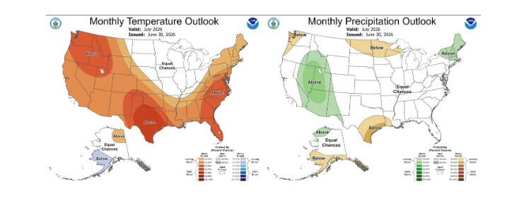
July Outlook Points to Heat and Persistent Western Drought
As Oklahoma transitions into the typical heat of mid-summer, the Climate Prediction Center’s July outlook indicates a strong probability of above-normal temperatures across the state. For precipitation, the outlook forecasts equal chances of above-, below-, or near-normal rainfall.
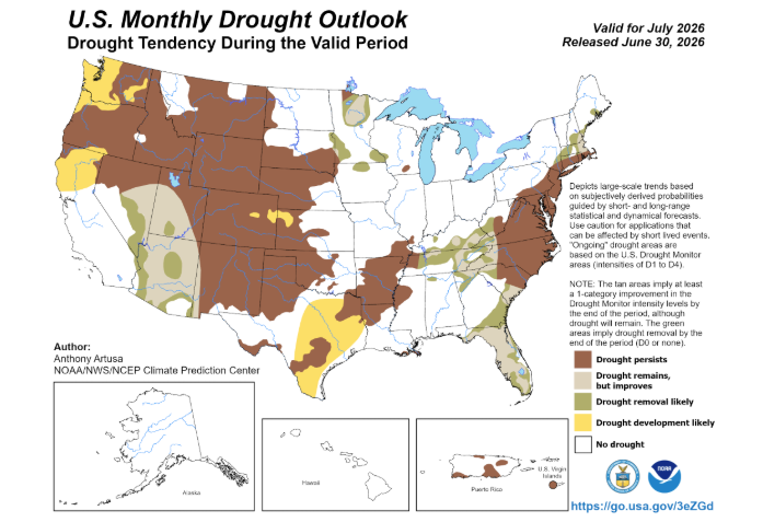
This neutral rain outlook leaves the trajectory of ongoing drought recovery highly uncertain. The monthly drought outlook projects that drought conditions will persist across much of western Oklahoma, including the hard-hit Panhandle and west-central communities. Conversely, eastern and central regions that benefited from June’s heavy rains face minimal drought concern heading deeper into the summer months.
To read more from State Climatologist Gary McManus on his mesonet ticker, click here:


