

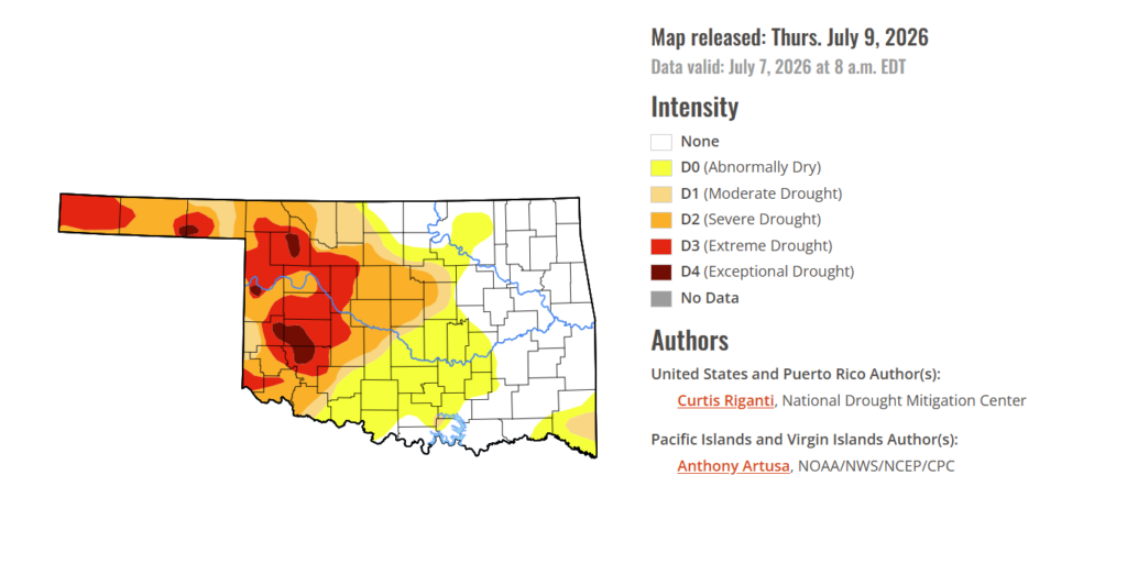
To view the latest Oklahoma drought map, CLICK HERE.
According to the Drought Monitor, exceptional drought has remained unchanged this week. Conditions are still present in Washita, Kiowa, Beckham, Woodward, Beaver, Roger Mills, and Texas counties. Exceptional drought now covers only 1.75% of the state compared to 7.13% two weeks ago.
Moderate to extreme drought conditions in the current period indicate that 43.81% of the state is affected. At this point, 35.42% of the state remains drought-free.
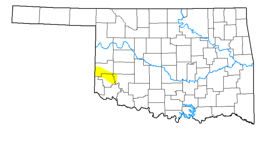
While this week’s Drought Monitor shows little change compared to last week, the bigger picture tells a different story. Oklahoma’s drought conditions have improved dramatically from 5 weeks ago, when peak exceptional drought reached 9.21%. Even so, conditions remain considerably worse than they were at this time in July 2025, highlighting that while recent rainfall has brought meaningful relief, many areas of the state are still working to recover from a challenging year of persistent drought.
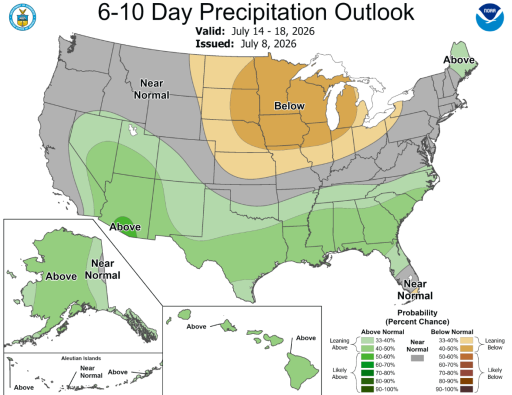
According to the 6-to-10-day precipitation outlook map, Northern Oklahoma is expexting near normal conditions through July 18th while southern Oklahoma is leaning above a 33-40% chance of rain through that same date.
Dry weather enveloped much of the western U.S. this week, with a few exceptions, leading to persistence or worsening of ongoing drought in the Northwest and in the Rocky Mountains in Wyoming and Colorado. Farther east, in the Great Plains, a mix of degradations, improvements or no changes to drought status or lack thereof occurred, as scattered hit-or-miss showers and thunderstorms moved across the Great Plains this week. Improvements were most prevalent in western Kansas and northeast Colorado, in parts of west Texas and southeast New Mexico and along the Missouri and Big Sioux Rivers in Nebraska and southeast South Dakota. Degradations occurred in parts of central and north-central Colorado, in north-central and northwest South Dakota and in parts of central and east-central Nebraska. This week’s rainfall and continued assessment of the impact of previous rains led to widespread improvements in Arkansas, northern Louisiana and portions of Kentucky and Tennessee. Heavy rains, locally exceeding 5 inches, drenched areas in central and northeast Iowa, southeast Minnesota and west-central Wisconsin, leading to widespread one- and isolated two-category improvements in areas where drought or abnormal dryness was ongoing. Short-term abnormal dryness emerged in parts of the Michigan Upper Peninsula and northeast Minnesota, and in areas just southeast of St. Louis after a drier-than-normal last couple of months. Heavy rains, locally exceeding 4 inches, drenched parts of the northern mid-Atlantic region, the New York City area and southern New England, leading to localized improvements. Ongoing groundwater shortages and long-term precipitation deficits somewhat tempered this week’s categorical improvements, though the rain improved the short-term picture in many areas. Similarly, localized heavy rains, in some places exceeding 5 inches, fell in the Florida Peninsula, locally improving conditions amid remaining low lake levels and longer-term precipitation shortfalls. Short-term dryness began to emerge again across parts of northern Georgia, the Carolinas and parts of adjacent Virginia, leading to low soil moisture and streamflow in areas already experiencing long-term dryness or drought. Recent very dry weather continued in much of Puerto Rico, leading to expansion of moderate drought and the expansion of severe drought along parts of the island’s southern coast. Short-term moderate drought also developed this week in northwest Alaska, while several areas of abnormal dryness developed or expanded.
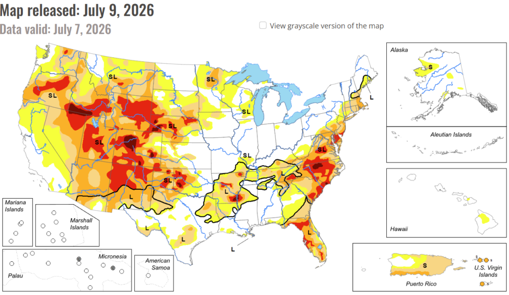
In the South: Near- or warmer-than-normal temperatures covered most of the South this week. Rainfall amounts varied, with some areas staying completely dry, though amounts over 2 inches fell in parts of southern Arkansas, northern and southern Louisiana, central and western Tennessee, northeast Texas and a few parts of the Texas Panhandle and western Texas. Deficits in soil moisture and precipitation lessened in parts of far western Oklahoma, the Texas Panhandle and other areas of western Texas, leading to some improvements in ongoing drought. Likewise, long-term drought conditions were improved in portions of central Tennessee, aided by rains this week. A small area of severe drought developed in north-central Tennessee, where precipitation deficits grew and soils dried. Recent rainfall also improved soil moisture, streamflow and lessened precipitation shortages across much of northern and southeast Louisiana and central and southern Arkansas, leading to widespread improvements to drought or abnormal dryness. Isolated improvements also occurred in northwest Mississippi, though conditions across Mississippi were mostly stable as far as drought or dryness.
In the High Plains: Temperatures in the High Plains region were mostly near- or warmer-than-normal this week, with temperatures in eastern Nebraska and eastern South Dakota ranging from 3-6 degrees above normal. (Temperatures west of the Continental Divide were mostly below normal, though conditions in Wyoming and Colorado will be discussed in the West section.) Deficits in precipitation and soil moisture grew in parts of eastern Nebraska, where abnormal dryness and moderate drought expanded. North-central and western South Dakota also saw expansion of abnormal dryness and drought as short- and long-term precipitation deficits grew amid declining soil moisture and streamflow. Parts of central Colorado, especially near and east of Denver and Colorado Springs, saw conditions degrade this week as precipitation deficits grew. Similar conditions in north-central Colorado and south-central and northwest Wyoming, leading to degradations there. A small area of improvement occurred in north-central Wyoming, where vegetation conditions improved after recent precipitation. Scattered heavier rains fell in showers and thunderstorms that moved across parts of the Great Plains of northeast Colorado, the northern half of Kansas, parts of southwest and southeast Nebraska, and the Missouri and Big Sioux River corridors in South Dakota and northeast Nebraska. These rains locally improved drought or abnormally dry conditions.
In the West: Precipitation fell in portions of the Idaho-Montana border and across parts of southern and eastern Montana, and in a few areas of northwest Washington. Rainfall amounts around an inch fell in parts of New Mexico, though heavier amounts were mostly confined to east-central and southeast parts of the state, where conditions were re-assessed and local improvements occurred. Otherwise, much of the West region was dry this week. Conditions worsened in parts of central and southwest Colorado, where multiple large wildfires were occurring in areas of low soil moisture and large precipitation deficits. Degradations also occurred in parts of Oregon and adjacent far northern California and in north-central Washington. In these areas, streamflow levels remained low and precipitation deficits at both short- and long-term timescales grew. Water deliveries to properties near Bend, Oregon, were shut off this week as water supplies rain low. Widespread severe and extreme drought also continued in the eastern half of Nevada, Colorado, Wyoming, New Mexico, Utah and southern Idaho. Temperatures across the West region were mostly near- or cooler-than-normal, with temperature anomalies of 3-6 degrees below normal spreading across much of California, Nevada and parts of Arizona.
To view the 6-10 Day Precipitation Outlook Map, click here.
To view the 6-10 Day Temperature Outlook Map, click here.
To view the Monthly Drought Outlook Map, click here.