

To view the latest Oklahoma drought map, CLICK HERE.
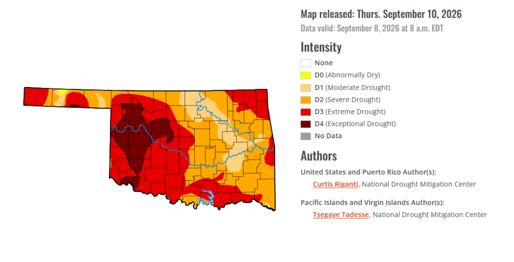
Drought conditions continue to worsen across Oklahoma, with exceptional drought expanding this week to cover 13.13% of the state and moderate to extreme drought affecting all of Oklahoma. Some rain fell overnight and into Thursday morning in central Oklahoma, offering a little relief, while the outlook continues to lean toward above-normal precipitation chances through September 19.
According to the Drought Monitor, exceptional drought has expanded by .49% this week. Conditions are present in much of western Oklahoma. Exceptional drought covers 13.13% of the state.
Moderate to extreme drought conditions in the current period indicate that 100% of the state is affected. At this point, 0% of Oklahoma has drought-free conditions, and the closest area experiencing drought-free conditions is northern Kansas.
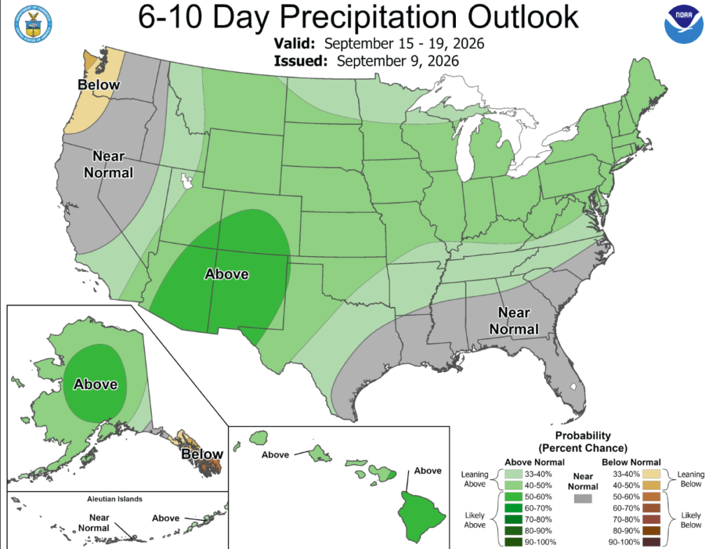
According to the 6-to-10-day precipitation outlook map, Oklahoma is leaning above a 33-50% chance of rain through September 19th.
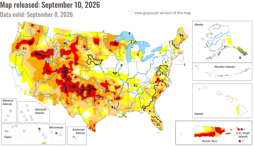
Drought and abnormal dryness continued to expand or intensify this week across parts of the central and south-central United States as flash drought conditions continued from much of Texas northeast to the middle and lower Mississippi River Valley. Warmer-than-normal temperatures, ranging from 10-15 degrees F above normal in much of the central Great Plains, Corn Belt and Missouri, combined with mostly dry weather in these areas to support worsening drought. Largely drier weather also continued this week in New England, in parts of the Michigan Upper Peninsula, along parts of the North Dakota-South Dakota border, in southeast Montana and in southwest Colorado, leading to degradations occurring in parts of these areas. In contrast, heavy rains fell from southeast South Dakota into western Iowa and southern Minnesota, in eastern Wisconsin, in northern North Dakota, in western Oregon and in parts of the northern Rocky Mountains in Montana and Idaho. Scattered heavy rains, locally 2-3 inches or more, also occurred in parts of Pennsylvania, New Jersey and Delaware, eastern North Carolina and Florida. Tropical Storm Edouard and its remnants delivered very heavy rain amounts, locally 10-15 inches or more, in a narrow corridor in southeast Texas. Lowell, in the central Pacific Ocean, delivered heavy rain amounts to Niihau, Kauai and Oahu as it passed west of the islands as a hurricane earlier this week, alleviating abnormal dryness in a few areas. Conditions continued to improve in localized areas of Puerto Rico this week after recent heavy rains. While the central United States dealt with an early-autumn heat wave, near- or below-normal temperatures occurred from the Great Basin west to the Pacific Ocean.
In the South: Large parts of the South region continued to quickly dry this week amid mostly above-normal temperatures and dry weather. A few exceptions include southern Louisiana, southeast Texas (where former Tropical Storm Edouard dropped rain amounts that locally exceeded 10 inches), and parts of the western Oklahoma Panhandle, where scattered thunderstorm rains occurred. Isolated one-category improvements occurred in the Oklahoma Panhandle, while one- and two-category improvements occurred in southeast Texas, where precipitation deficits were either reduced or erased entirely, along with improved soil moisture and streamflow. Elsewhere, mostly dry weather and hot temperatures (5-15 degrees above normal) covered a wide area from western and northern Texas through most of Oklahoma, Arkansas, northern Mississippi and Tennessee. Short-term rainfall deficits continued to grow across much of the region, along with dropping soil moisture and streamflow levels, leading to widespread agricultural drought impacts. Large areas of degrading conditions spread from much of Texas into eastern Oklahoma, Arkansas, northern Mississippi and portions of Tennessee. The rapidly drying weather in Tennessee came after much wetter recent weather, somewhat lessening the impact of the recent heat and dryness there and in neighboring Kentucky.
In the High Plains: Conditions in the High Plains region this week were mixed. Scattered heavy rains fell in northeast and southwest Nebraska, southeast South Dakota, northern North Dakota and far southwest Kansas, leading to localized or widespread improvements in these and neighboring areas. However, temperatures across the region were warmer than normal, leading to abnormally high atmospheric thirst and widespread degrading conditions in parts of the region. Temperatures were mostly 10-15 degrees above normal in Kansas, eastern Nebraska and southeastern South Dakota. Eastern Kansas and southeast Nebraska were particularly hot and dry this week, leading to large expansions of moderate, severe and extreme drought in south-central and southeast Kansas, and the introduction of abnormal dryness in much of northeast Kansas. Unusually wet weather in August kept conditions in southeast Nebraska from drying as much as areas farther south and southeast. Severe and extreme drought also grew in coverage in southeastern North Dakota, where warm and dry weather this week worsened precipitation deficits and soil moisture conditions. Drought conditions improved in southeastern South Dakota, and adjacent far northeast Nebraska, where rain amounts of 2-5 inches fell. Similar amounts of rain fell in parts of northern North Dakota, leading to improvements in soil moisture and streamflow there and improving drought conditions. Heavy rain amounts of 1-3 inches fell in parts of southwest Nebraska and the Nebraska Panhandle, and adjacent northeast Colorado, lessening precipitation deficits and improving drought conditions.
In the West: Most of California, Oregon, Washington and Idaho were cooler-than-normal this week, with some areas of northern California and southern Oregon finishing the week 10-15 degrees below normal. Eastern portions of New Mexico and Montana, by contrast, were warmer than normal, with temperatures in most areas 5-10 degrees above normal. Widespread moderate to heavy precipitation fell from northern California across portions of Oregon, central and northern Idaho and western and northern Montana. Precipitation amounts in western Montana and northern Idaho ranged from 2 to 6 inches. This led to increased soil moisture and streamflow and lessened short- and long-term precipitation deficits, and the coverage of moderate and severe drought and abnormal dryness lessened in some areas. Precipitation also improved conditions in south-central Oregon, as long-term precipitation deficits lessened in severity. Long-term precipitation deficits grew amid groundwater and soil moisture shortages in south-central Nevada, leading to an increase in severe drought coverage there. In southeast Montana, warm and dry weather led to decreased streamflow and soil moisture in a few areas, leading to localized expansion of severe and extreme drought.
To view the 6-10 Day Precipitation Outlook Map, click here.
To view the 6-10 Day Temperature Outlook Map, click here.
To view the Monthly Drought Outlook Map, click here.