
A developing winter weather pattern across the Southern Plains will deliver a sharp contrast in seasonal moisture, cold air, and frozen precipitation for Oklahoma agricultural producers. Farm Director KC Sheperd recently sat down with AccuWeather meteorologist Chad Merrill to examine the full winter outlook, breaking down projected temperatures, snowfall expectations, ice storm probabilities, and the suite of forecasting tools available to help farmers and ranchers plan operations through a shifting El Niño season.
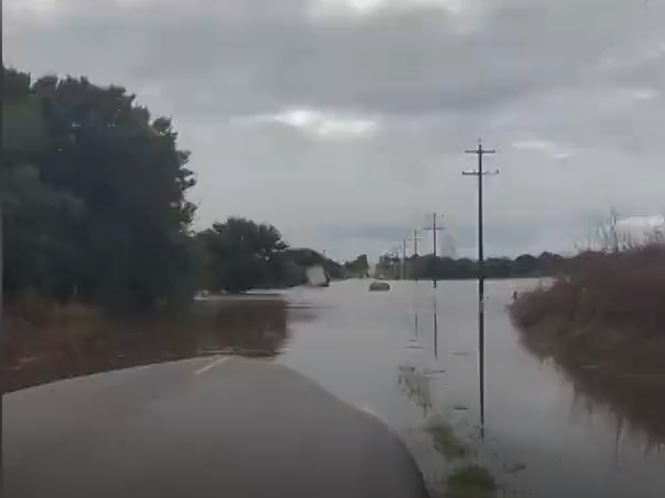
While recent storms brought drought-breaking downpours across the Southern Plains, Merrill emphasized that the atmosphere is locking into a robust El Niño regime that will dominate late fall and winter. That pattern shift brings a steady transition from unseasonable warmth into much cooler, seasonal conditions.
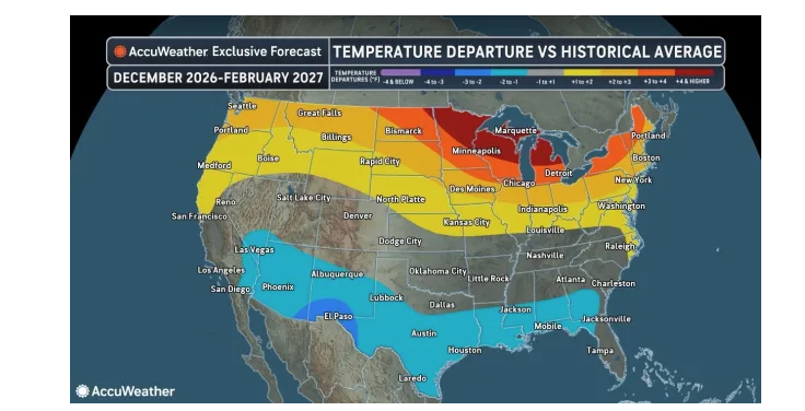
Winter Temperature Outlook
Merrill noted that while producers should expect considerably cooler weather through the late fall and into midwinter, the Southern Plains will largely escape true Arctic outbreaks.
“We really don’t see any Arctic intrusions that are going to come farther south,” Merrill explained. “A lot of the temperature departures are actually from the clouds and precipitation. There’s just enough cold air on the northwestern part of these storm systems to produce a little bit of snow. Daytime highs are going to be kept down because of the clouds and precipitation, but the nighttime lows aren’t going to break any records or get extremely cold for an extended period”.
Extended periods of lingering, deep freezes are not expected to take hold across the region. Instead, daytime heating will remain muted under persistent cloud decks and storm tracks, while subfreezing air behind individual storm systems will generally move out within one to two days rather than settling in for long stretches.
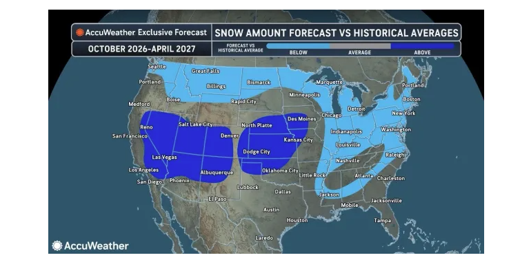
Snowfall Distribution Across the Southern Plains
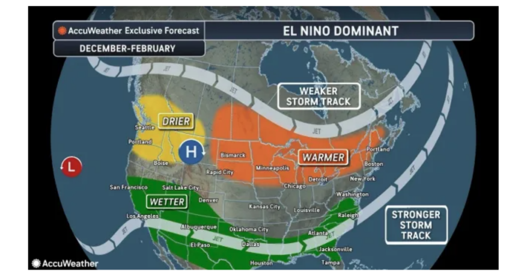
The primary winter storm track is projected to emerge from the Southwest, tracking across the Southern Plains and cutting northeast toward St. Louis and the mid-Mississippi Valley. This orientation will create a distinct divide in snowfall across the region:
- North and West of Oklahoma City: Areas situated on the colder, northwestern flank of the storm track—including the Oklahoma Panhandle, northwest Oklahoma, and across Kansas—are forecast to receive above-average snowfall this winter.
- Central and Southern Oklahoma: For Oklahoma City and central portions of the state, seasonal snowfall is projected to finish slightly below average, with total accumulations expected between 3 to 5 inches, compared to the normal seasonal average of about 6.5 inches.
- South and East into Texas: Farther south and east across Texas and the Gulf Coast corridor, near-average snowfall to predominantly cold rain will prevail as secondary southern storm tracks stay loaded with Pacific moisture.
Merrill noted that the frequency of these winter storm systems will be fairly abundant, particularly from late December into January. Several distinct systems during that window could produce multiple events dropping a tenth of an inch up to two inches of snow at a time across the region.
Ice Threats and Historical Analogs
When assessing travel hazards and livestock stress from freezing rain and sleet, Merrill pointed back to the strong El Niño winter of 1997–1998 as one of AccuWeather’s leading analog seasons.
During that baseline year, the Southern Plains saw severe thunderstorms early in December, followed by a dramatic “weather whiplash” to snow and ice late in December and into the start of January.
Merrill cautioned that a similar setup is possible this season, with potential for at least one notable ice storm to impact the Southern Plains during the late December to early January window. However, because sustained Arctic air will be absent, any travel disruptions and glaze ice issues from such an event should remain short-lived, with temperatures recovering within 24 to 48 hours behind the departing system.
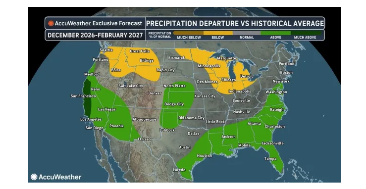
Jet Stream Dynamics and Broader Weather Whiplash
The broader atmospheric engine driving these winter setups will be an energized subtropical jet stream fueled by warm waters from El Niño and a marine heatwave off the Pacific Coast. Fluctuations in the Pacific Decadal Oscillation will interact with that jet stream, funneling upper-level energy through the Southwest and into Oklahoma, Texas, and Kansas.
While that active pipeline brings welcome moisture following severe drought, Merrill advised agricultural producers to prepare for volatile, variable weather patterns through January and February—balancing frequent snow and rain chances, occasional severe storms, and localized flash flooding against brief cold snaps.
AccuWeather Planning Tools for Agricultural Producers
To help producers plan fieldwork, harvest schedules, and livestock management around these shifting conditions, Merrill detailed several specific tools and resources provided by AccuWeather:
- Two-Week Precipitation Departure Maps: Broadcast on the AccuWeather Network early in the morning—typically between 4:00 a.m. and 10:00 a.m. on Tuesdays and Fridays—these maps project expected rainfall and precipitation departures from average two weeks in advance. Farmers can track upcoming dry windows to plan when they can safely take combines into the field for harvest or anticipate periods of adequate moisture during the growing season.
- Seasonal Client Outlooks: Tailored reports distributed to agricultural clients ahead of the spring and summer months to evaluate long-range risk factors.
- Drought Forecasts: Predictive seasonal mapping identifying where regional drought conditions are expected to develop or expand, as well as where existing drought footprints are projected to be erased.
- Harvest Forecasts: Operational seasonal outlooks analyzing whether upcoming fall or summer harvest periods will face poor weather delays or benefit from open harvest windows.
- Public Agricultural Webinars: Interactive webinars where farmers and ranchers can register to learn what weather trends to anticipate across specific segments of the agricultural belt, including detailed timelines on seasonal rainfall distributions so producers can proactively plan ahead.