

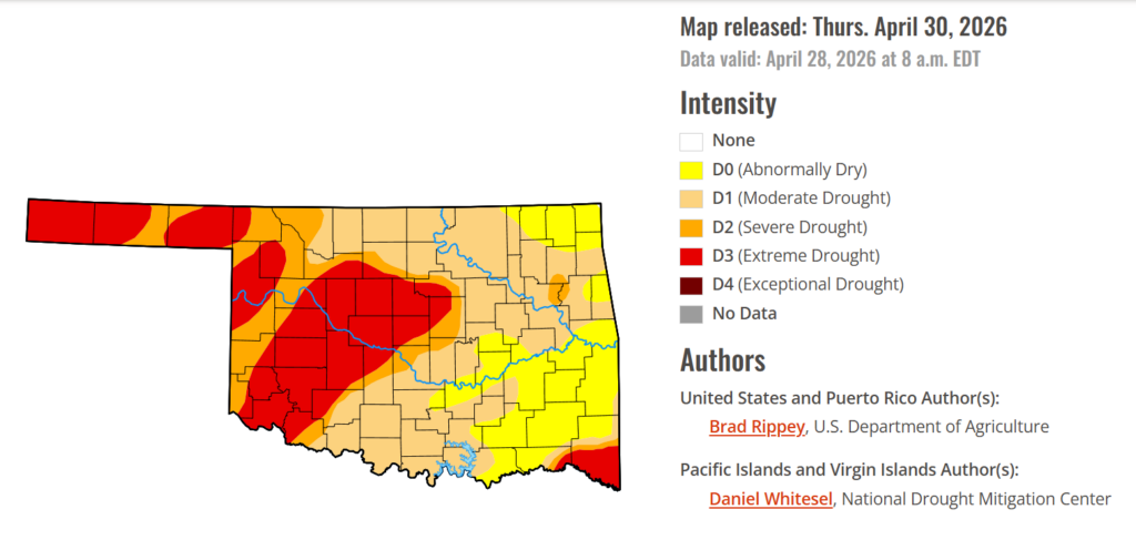
To view the latest Oklahoma drought map, CLICK HERE.
Drought in Oklahoma is starting to tell two very different stories depending on where you look across the state. In the east, recent rounds of rain are steadily easing conditions, nudging some areas out of deeper drought and back into lower tiers, while in western Oklahoma, the situation is moving in the opposite direction as extreme drought continues to expand its footprint. Even with better rain chances in the short-term outlook, the divide is growing more noticeable, with relief building in the east and intensifying stress gripping the west.
According to the latest Oklahoma Drought Monitor report, exceptional drought remains at 0 percent, unchanged from the start of the calendar year.
Moderate to extreme drought conditions in the current period indicate that 80.63% of the state is affected by drought, down 5 points from last week. Southeastern Oklahoma is seeing drought conditions ease, with areas shifting into the lower drought tier of abnormally dry conditions.
Extreme Drought conditions have increased this week by 4.24%, covering 30.08% of the state, affecting a majority of western Oklahoma.
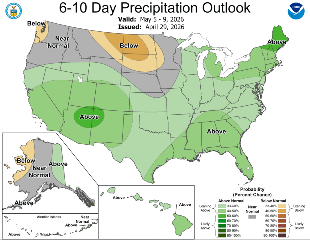
According to the 6-to-10-day precipitation outlook map, Oklahoma is leaning above a 33-40% chance of precipitation through May 9th, while the westernmost tip of the panhandle is leaning above a 40-50% chance.
Rain continued to bypass the central and southern High Plains, leaving rangeland, pastures, and winter wheat in desperate need of moisture. Farther east, however, showers and thunderstorms continued to ease drought across the eastern Plains, extending into the mid-South and Mississippi Delta. Some of the heaviest rain, accompanied by locally severe thunderstorms, fell from eastern Kansas into the lower Midwest. The remainder of the Midwest also received some precipitation, although some of the region’s wettest areas in the Great Lakes States got a break from the excessive rain that had led to pockets of record flooding earlier in the month. In contrast, much of New England and northern sections of New York were cool and dry. Elsewhere, unsettled, showery weather prevailed in the West, mainly north of a line from central California to the central Rockies, boosting topsoil moisture, delivering high-elevation snow, and reducing irrigation demands. However, any precipitation did not fundamentally change a mostly bleak Western water-supply outlook for the remainder of the spring into the summer of 2026.
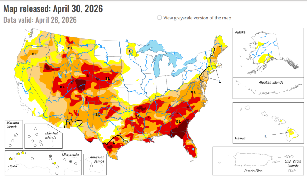
In the South: Late in the drought-monitoring period, significant rain overspread portions of the South, resulting in broad reductions in drought intensity. Some of the heaviest rain fell from eastern sections of Oklahoma and Texas into portions of Arkansas, Mississippi, and northern Louisiana. Still, more rain will be needed to ensure full drought recovery, since many of the hardest-hit areas had slipped into extreme to exceptional drought (D3 to D4) in recent weeks. Meanwhile, western sections of the South—including western Oklahoma and western Texas—remained critically dry, leading to poor rangeland, pasture, and winter wheat conditions, as well as a chronically elevated wildfire threat. Statewide, winter wheat in Texas was rated 56% very poor to poor on April 26, along with 45% in Oklahoma.
In the high Plains: Precipitation delivered drought relief to some areas, including parts of southern South Dakota and eastern sections of Nebraska and Kansas. Still, by April 26, topsoil moisture—as reported by the U.S. Department of Agriculture—was rated at least 40% very short to short in all the region’s states, except North Dakota, and led by Colorado (95%). Winter wheat continued to struggle due to drought and recent freezes, with 65% of Nebraska’s crop rated in very poor to poor condition on April 26, along with 54% in Colorado and 41% in Kansas. Drought continued to generally worsen in eastern Colorado and western sections of Kansas and Nebraska.
In the West: Any changes in the West were mostly minor and mixed, as cooler weather prevailed and spotty precipitation occurred. In most areas, Western precipitation did not alter bleak water-supply prospects, since most of the mountain snowpack has already melted, except in the northern Rockies. Already in late April, fears of an hydroelectricity generation crisis in the Colorado River Basin have led the Department of Interior to start sending water from Flaming Gorge Reservoir downstream to Lake Powell to help boost water levels. The Department of Interior also indicated that water normally destined for Lake Mead, farther downstream, would be held in Lake Powell. Despite overall lack of impact on Western supplies, any precipitation was largely welcomed, due to positive impacts such as a boost in topsoil moisture and a reduction in irrigation demands. In fact, enough precipitation has recently fallen to warrant a slight reduction in drought intensity in a few areas, including parts of western Colorado, northeastern Oregon, and southeastern Washington.
To view the 6-10 Day Precipitation Outlook Map, click here.
To view the 6-10 Day Temperature Outlook Map, click here.
To view the Monthly Drought Outlook Map, click here.


